©Copyright 2018 GEOSCIENCE RESEARCH INSTITUTE
11060 Campus Street • Loma Linda, California 92350 • 909-558-4548
All Galleries


A collection of original photos taken by GRI scientists, illustrating a variety of geological features.
All photos in this gallery are the property of the Geoscience Research Institute, and copyright rules apply. Noncommercial use is authorized with attribution as follows:
“Image copyright © Geoscience Research Institute, www.grisda.org. Used with permission."
Contact GRI for inquiries and further permissions.
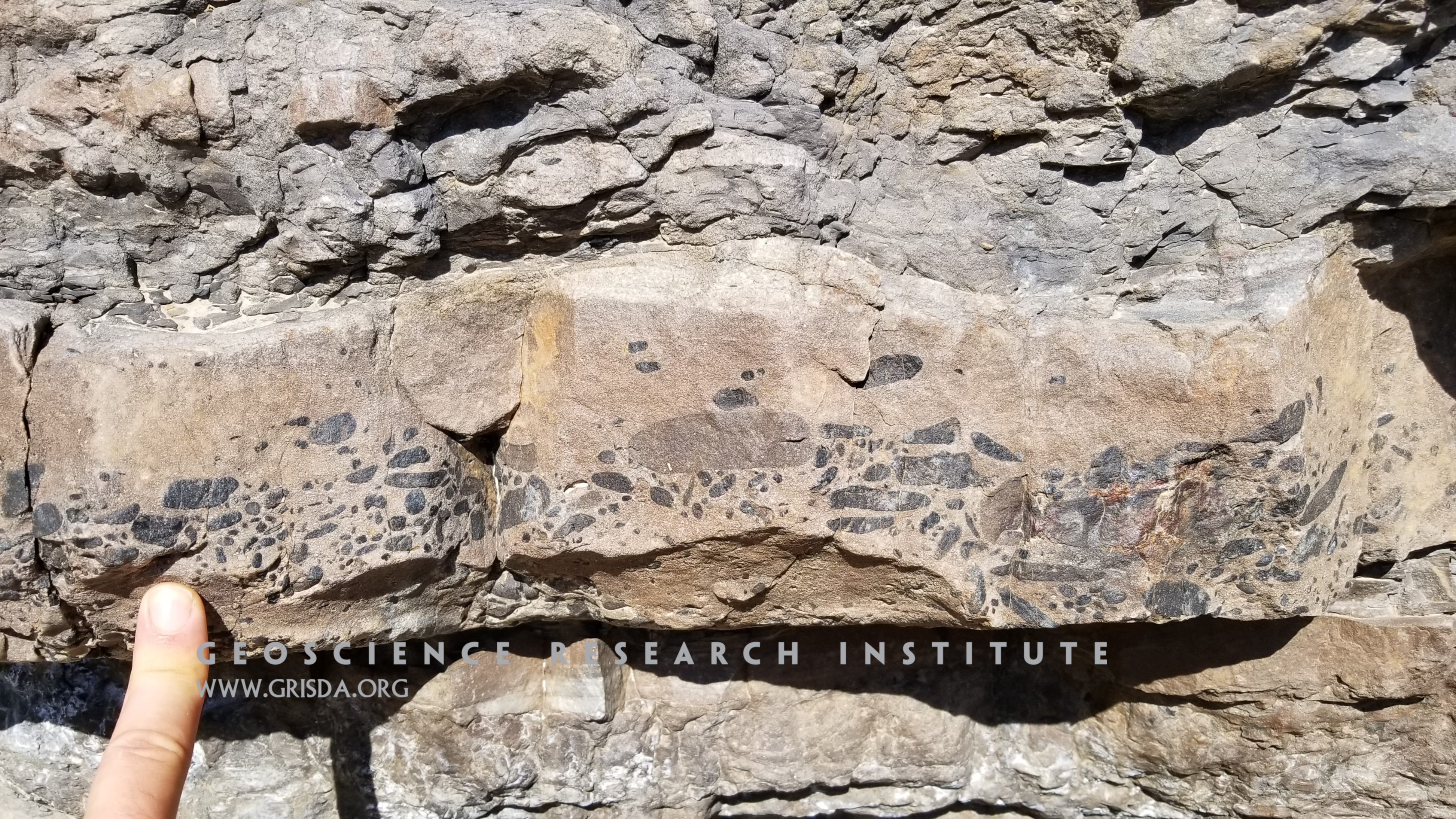
Pebbly layer
Elongated pebbles concentrated at the base of a sandstone bed. Some pebbles show evidence of boring. They probably were transported during a sediment gravity flow from shallower to deeper marine settings. Photo taken along the Quebrada Morochata, Bolivia.
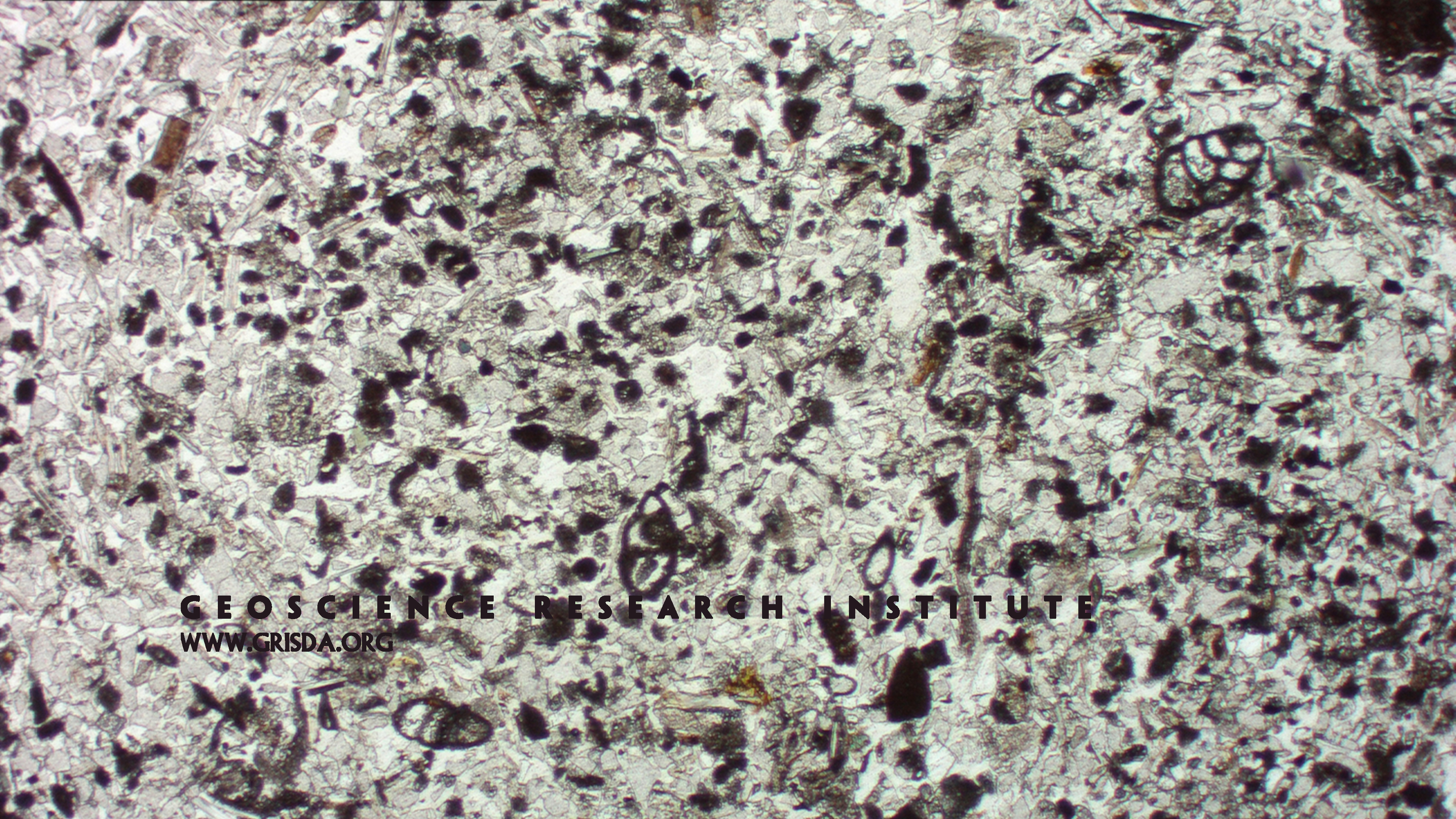
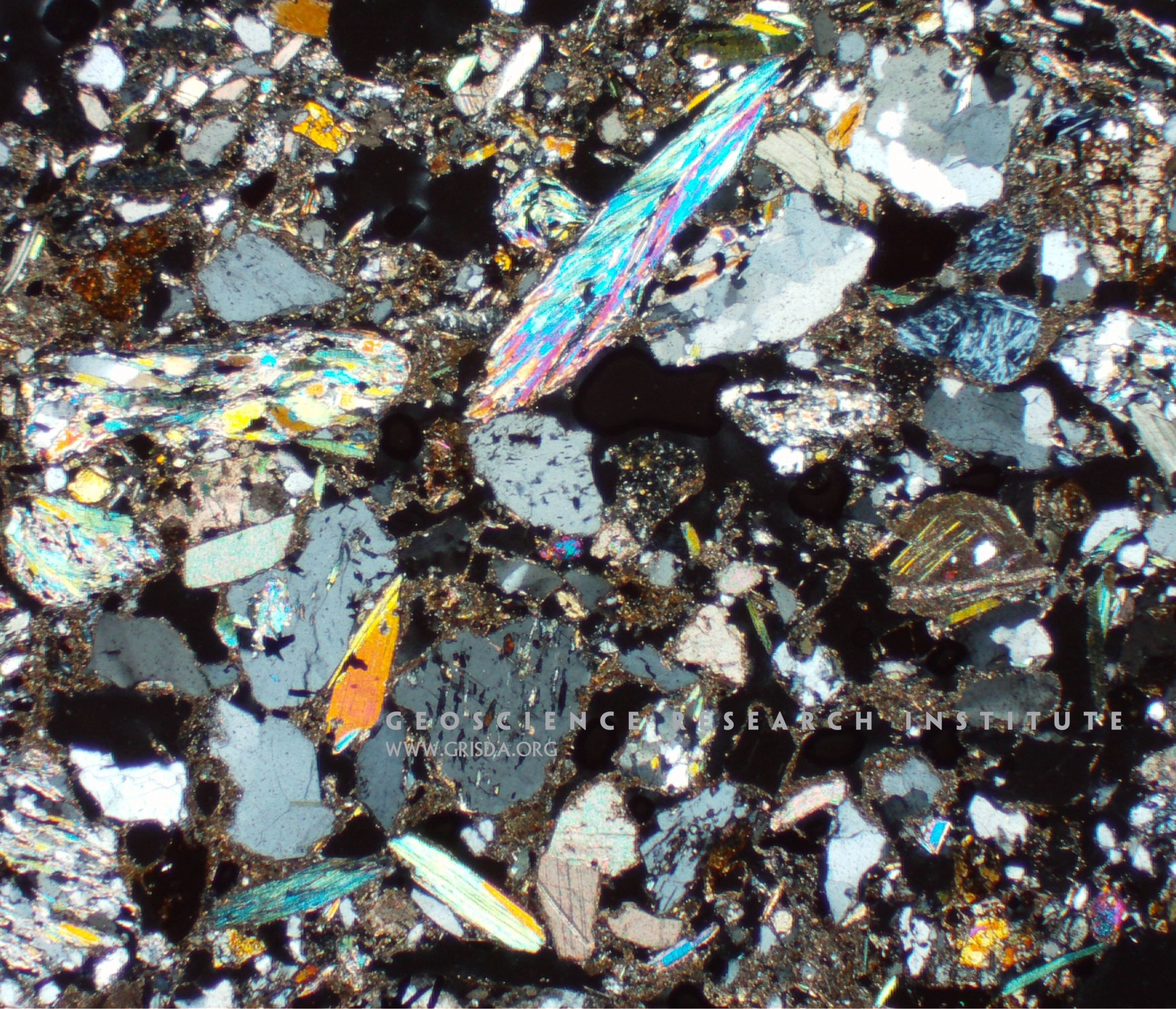
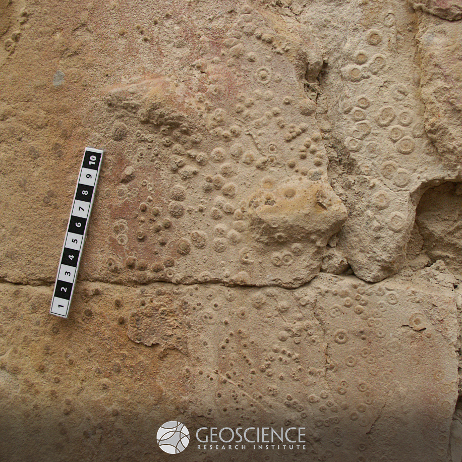
Benthic foraminifers
Thin section microphotograph (in plane parallel light) of a fine-grained, mixed siliciclastic-carbonate sandstone from Pliocene strata of the Sorbas Basin, Spain, containing tests of miliolid benthic foraminifers.
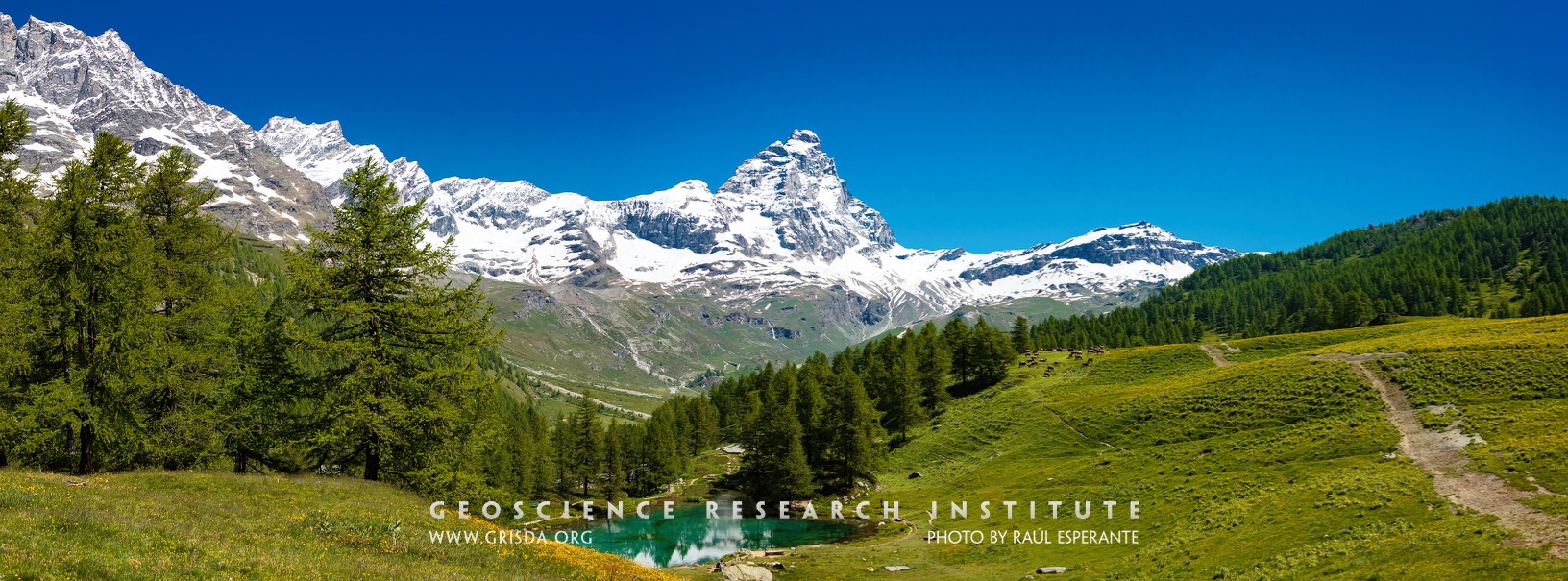
Cervino (Matterhorn)
The snowy peak of the Cervino. The Alps are a majestic mountain chain that records a history of continental collision and mountain rising. Glaciers and rivers have sculpted many valleys and contributed to the beauty of this natural landscape. Photo taken from Blue Lake, Cervinia-Breuil, Aosta, Italy.
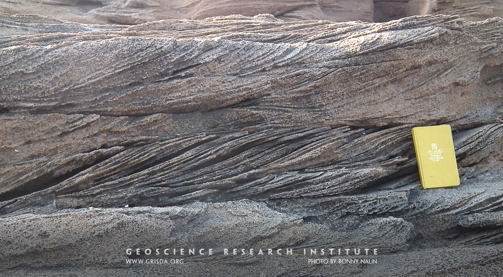
Cross-sets
Sedimentary structures like these cross-sets form through the migration of sand dunes on the sea bottom under the action of a current. They can be used to infer flow directions and energy, and even aid in the interpretation of the general depositional system. Pleistocene calcarenites from Le Castella, Calabria, Italy.
Flat pebbles
This picture shows three beds containing numerous intraclastic flat pebbles from upper Cambrian strata of the Notch Peak Formation, Utah. We find analogous flat-pebble conglomerates in lower Paleozoic strata from many different regions of the world, including China, North America, Australia, and Korea. In this and other similar cases, Paleozoic rocks record a global signal. Scale in cm.
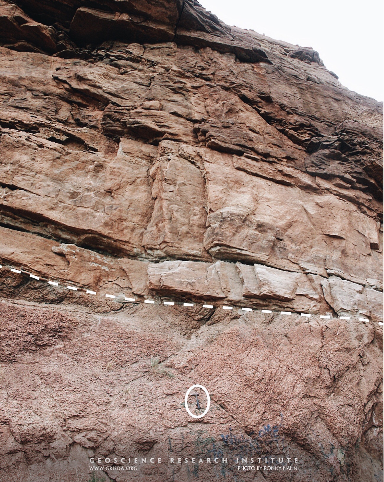
Great Unconformity
In many places around the world (and through most of the North American continent) Paleozoic rocks have a sharp discontinuity at their base. This widespread erosional surface, called “the Great Unconformity,” often separates layered sedimentary rocks from underlying metamorphic and igneous rocks (the so called “crystalline basement”). In this photo taken near Manitou Springs, CO, USA, the Great Unconformity is marked by the dashed line and overlain by the Cambrian Sawatch Quartzite. Hammer (encircled) for scale.
Confluence
A confluence is the point at which two streams flowing from different directions unite. This photo shows a confluence of two streams, approximately equal in size and width, draining the basement complex in north-central Nigeria.
Ravinement
The flat erosional surface separating gray clays (Argille Subapennine Fm., Pleistocene) from yellowish sands is called ravinement surface and was cut by waves in shallow water. Erosional surfaces in the rock record are essential for reconstruction of sea level and tectonic changes. They help unraveling the history of our planet but also illustrate the power of geologic processes. Photo taken near Canosa, Puglia, Italy.
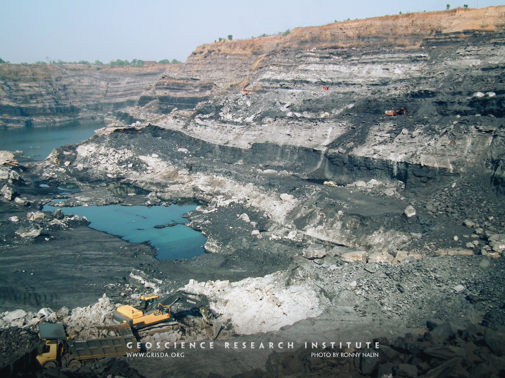
Coal mine
TOPA open-pit coal mine, Jharkhand, India. Laterally extensive coal seams represent a significant reserve of fossil fuels. No modern analogue can be offered as a counterpart to some of these ancient beds.
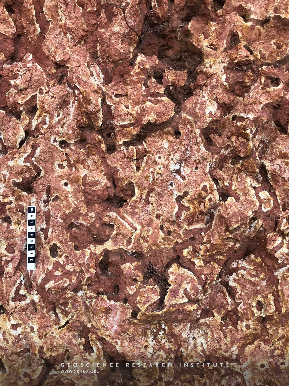
Pedogenesis
Pedogenesis is the process of soil formation. This photo shows a vertical section of a modern soil profile, with root traces and carbonate concretions. Scale in cm. Location: Muhanga District, Rwanda.
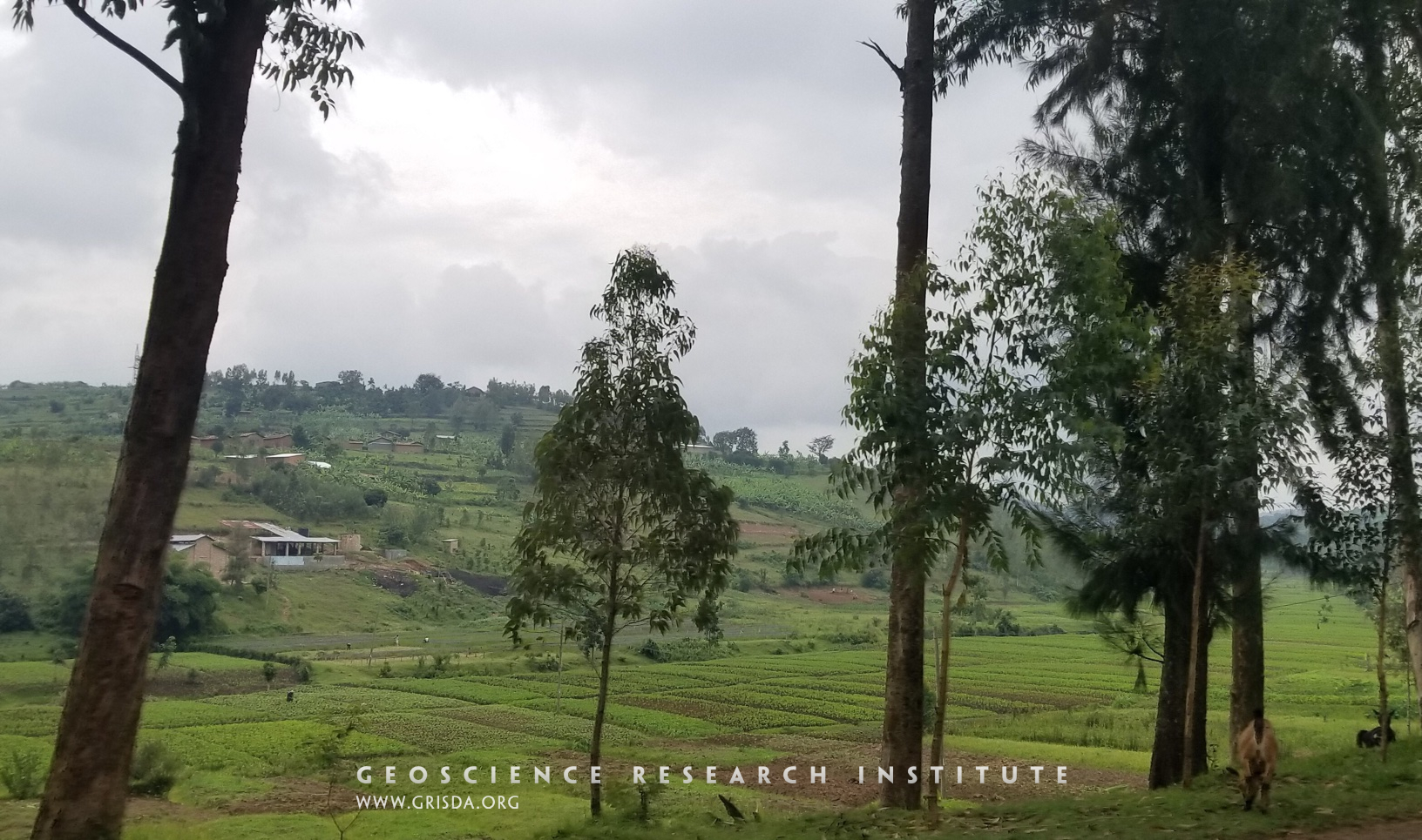
Hills
Rwanda is known as the country of a thousand hills. These hills are mostly made of Precambrian rocks. However, the valleys between these hills are filled with alluvial deposits that provide a fertile soil for cultivation. Photo taken in the Kigali district.
Faulting and deformation
Normal faulting of layers has resulted in lowering of the block to the right of the image. Note, however, the presence of an intensely deformed area along the fault zone, with evidence of plastic deformation. Cretaceous El Molino Formation, near Torotoro, Bolivia.
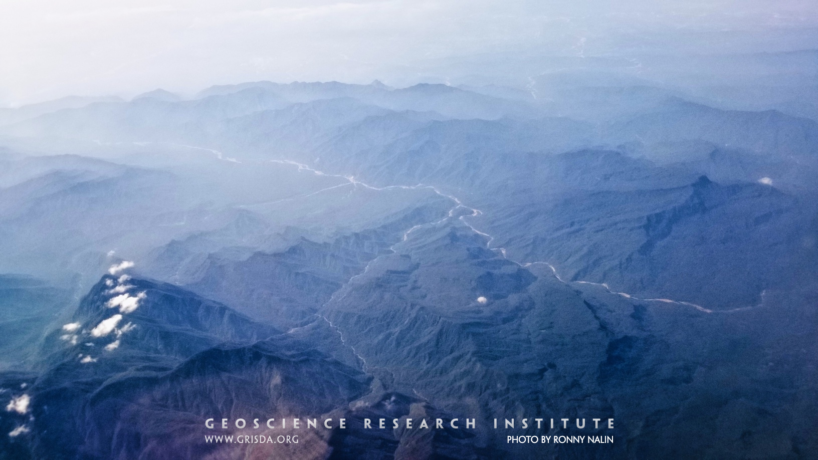
Volcano
A volcanic cone emerges from the clouds on a flight over the islands of Indonesia. The Java trench is one of the most tectonically and volcanically active regions of the earth.
Moraine Lake
Talus cones, a glacial lake, and Cambrian quartzites: a perfect combo for a gorgeous landscape. Banff National Park, Canada.
Valleys
An example of transverse and longitudinal valleys from the Bolivian Andes, Parque Nacional Carrasco, reflecting structural control on geomorphology.
Monocline
A monocline is a fold with a subhorizontal flank passing into a high angle flank. It is usually related to the activity of a tectonic lineament, like a thrust.
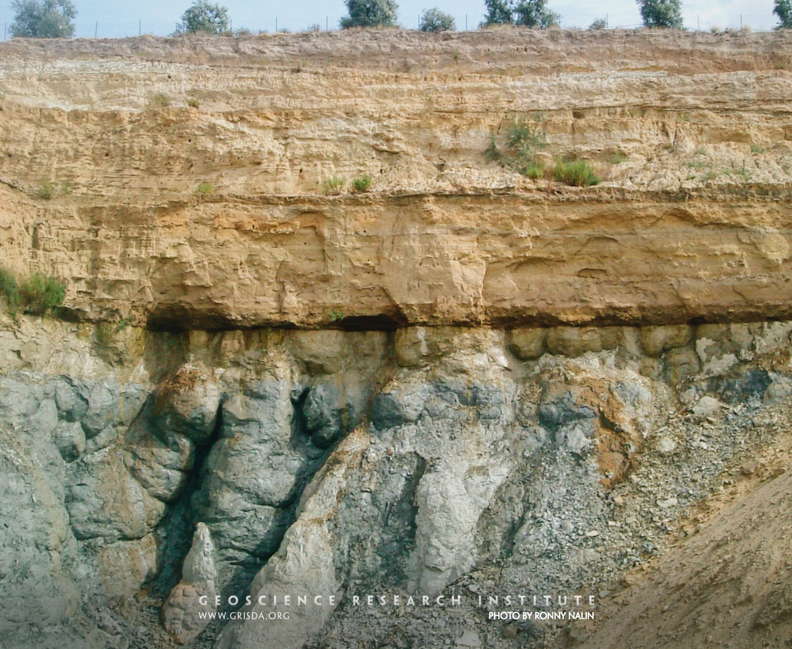
Load structures
When sediment is still unconsolidated, it can deform under sudden solicitation (e.g., seismic shocks or load by additional sediment). Water expelled from intergranular pores can generate distinctive soft sediment deformation structures, known as ball-and-pillow structures or load structures, typically found at the contact between sandstone and mudstone beds.
Channel
In sedimentology, a channel is a lensoidal architectural element with a concave erosional base.
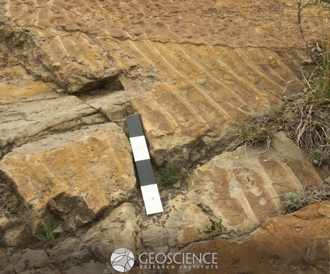
Epsilon cross-stratification
As meandering rivers move on a floodplain they can generate distinctive cross-stratified deposits related to lateral migration of point bars. The cross-set at the center of the photo is several meters thick.
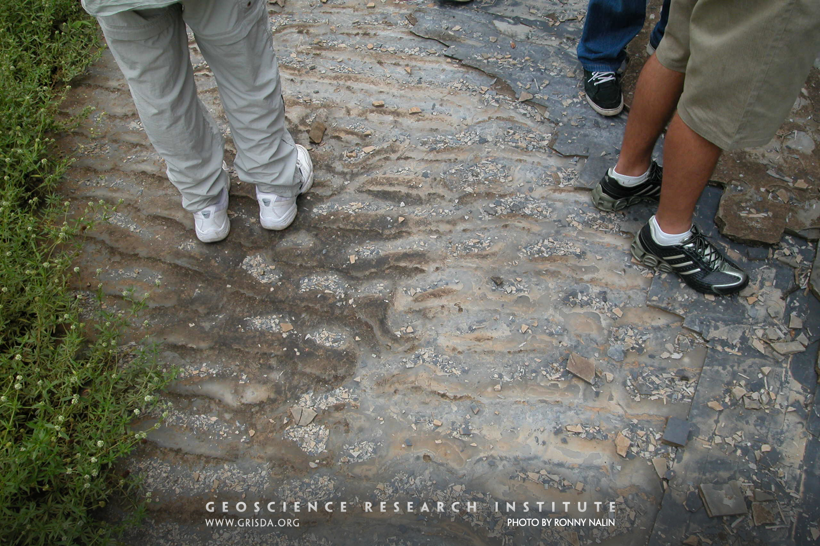
Current ripples
Walking on water? Not really, but these ripples, now petrified, formed under shallow water and are exposed on the floor of a quarry at the Varvito Park, Ito, Brazil. They are part of exposures of Permian sandstone from the Itararé Group. The ripple crests are mostly linear and the profile of the ripple is asymmetric, allowing to reconstruct the direction of flow (towards the viewer).
Asymmetric ripples
Current ripples are small asymmetric bedforms generated by movement of fine-grained sediment under unidirectional currents. The presence of climbing ripple lamination indicates rapid deposition from a sediment-laden flow. Upward transition from planar lamination to current ripple lamination is indicative of flow deceleration. Sequence of sedimentary structures (cf. Bouma sequence), grain size decrease, and cyclical repetition of bedding points to deposition from turbidity currents. Photo taken at the Varvito Park, Ito, Brazil, with exposures of Permian strata from the Itararé Group. Scale in cm.
Climbing ripples
When a fluid laden with sediment rapidly drops some of its load as it is flowing, a sedimentary structure named "climbing ripple lamination" can form. It is characterized by superimposed ripple crests (or ripple cross-sets) migrating in the direction of flow. Photo taken at the Varvito Park, Ito, Brazil, with exposures of Permian strata from the Itararé Group. Scale in cm.
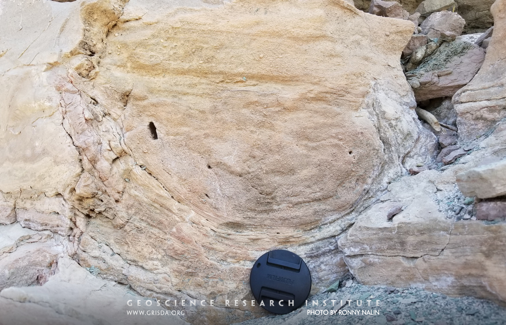
Dropstone
Dropstones are outsized rock clasts much larger than the average grain size of the surrounding sediment. Rather than being laterally transported by a flow, they show evidence (in the form of displacement of underlying lamination) of vertical sinking onto the substrate. The dropstone in the picture has a diameter of about 20 cm and is included in turbiditic deposits (Permian Itararé Group, Itu, Brazil).
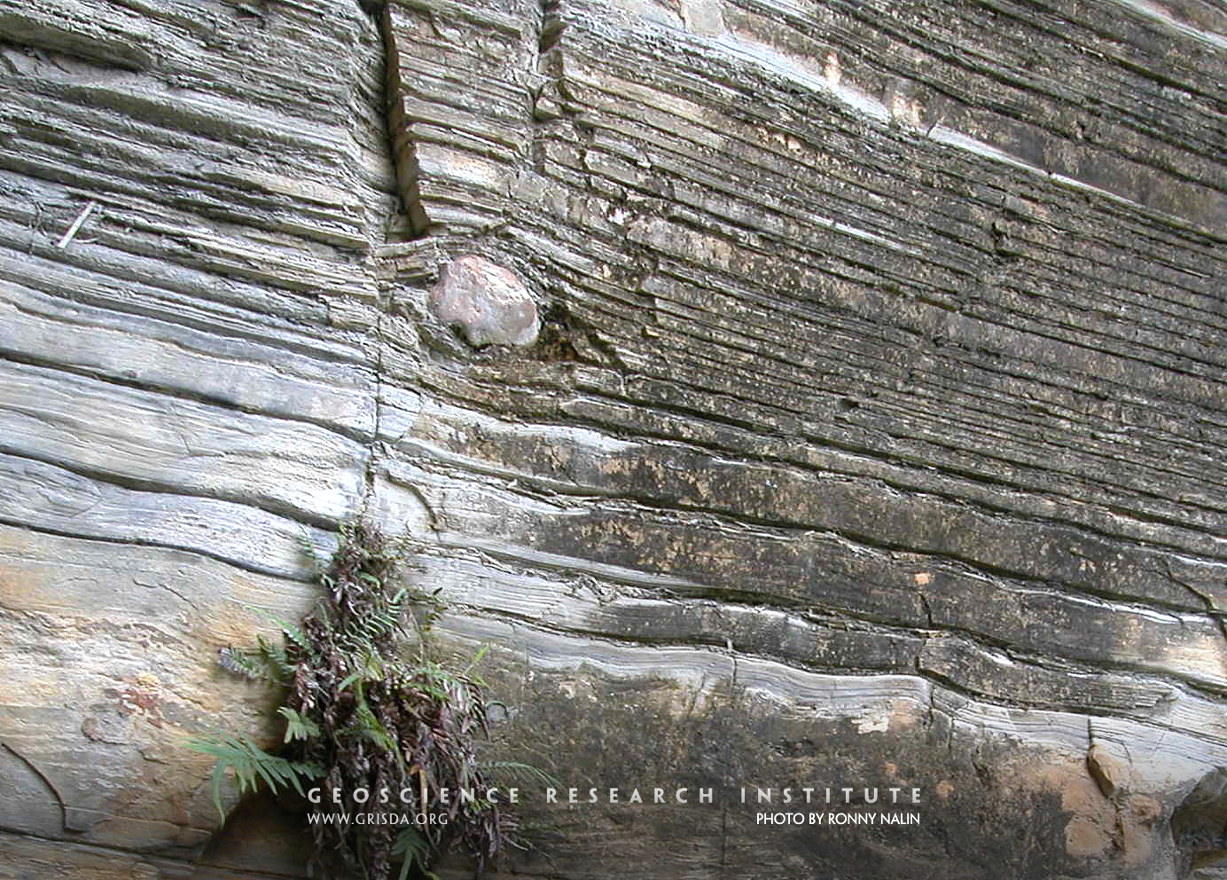
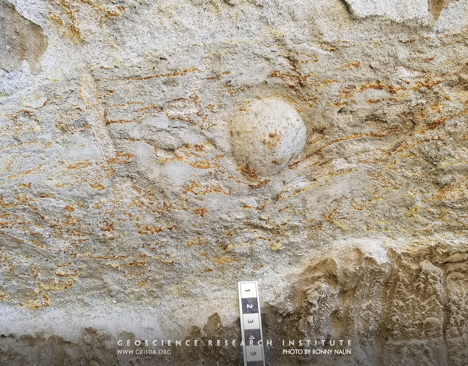
Outsized clast
Outsized clasts are isolated rock fragments encased in much finer sediment and their mode of transport and deposition is therefore puzzling. One way to explain their occurrence is the "dropstone" model (vertical sinking from floating rafts or icebergs). However, gravity flows can also carry outsized clasts in sand-laden waters. This picture shows a well-rounded granitic outsized pebble encased in bioturbated sandy turbidites of a submarine channel complex of the Mio-Pliocene Capistrano Formation (San Clemente State Beach, California). Scale in cm.
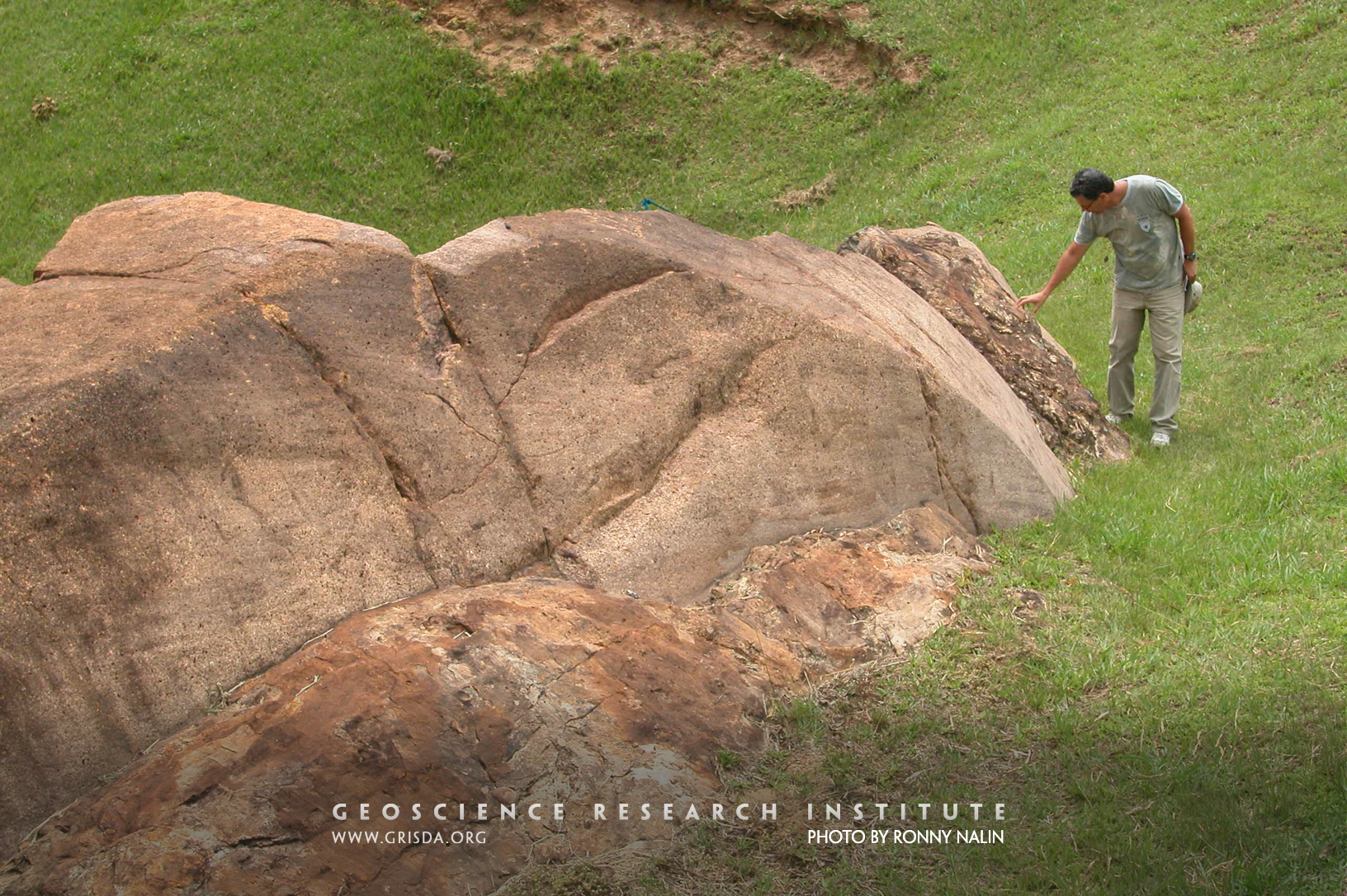
Bedrock abrasion
Glaciers can levigate the bedrock over which they flow, smoothing irregularities into a glaciogenic landform called "roche moutonnée." This example from the rock record (Paranà Basin, Brazil) is interpreted as evidence for Permian glacial activity. The bedrock is granitic and it is overlain by patches of diamictite (reddish deposit). Several sedimentary processes can generate bedrock abrasion and a glaciogenic origin for features in the rock record should be presented with caution and based on a combination of multiple lines of evidence.
Diamictite
Diamicton is the term used to describe a poorly sorted, matrix-supported, clastic deposit with particles of a wide range of sizes. There are many processes that can generate diamicton, but this type of deposit is often associated with the action of glaciers. This photo shows a Permian example of lithified diamicton (diamictite), from the Paranà Basin, Brazil, found above a striated bedrock surface and traditionally interpreted as glaciogenic.
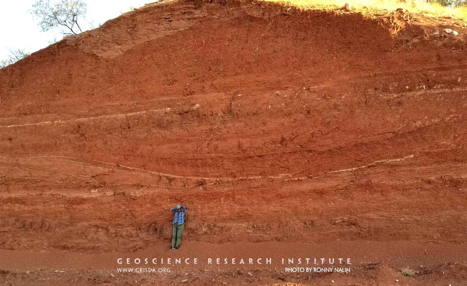
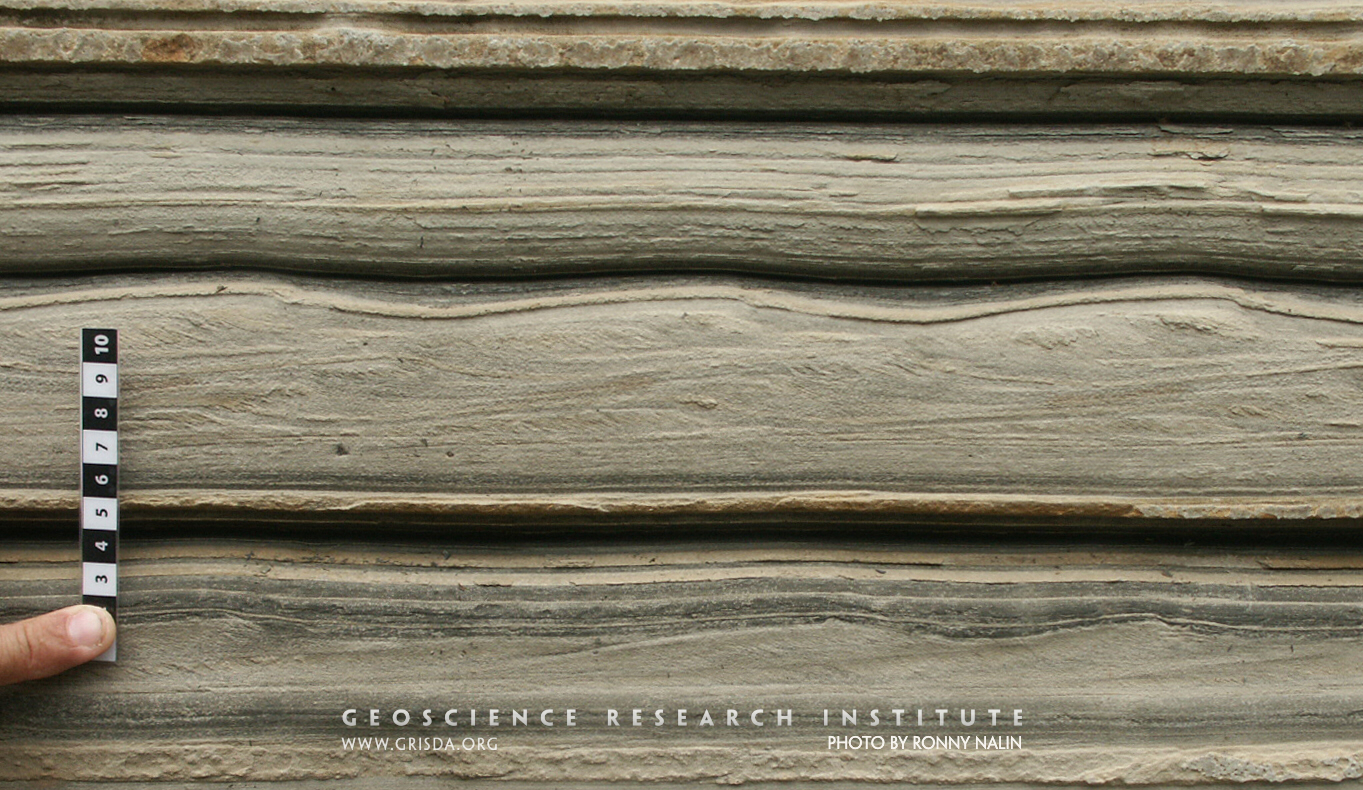
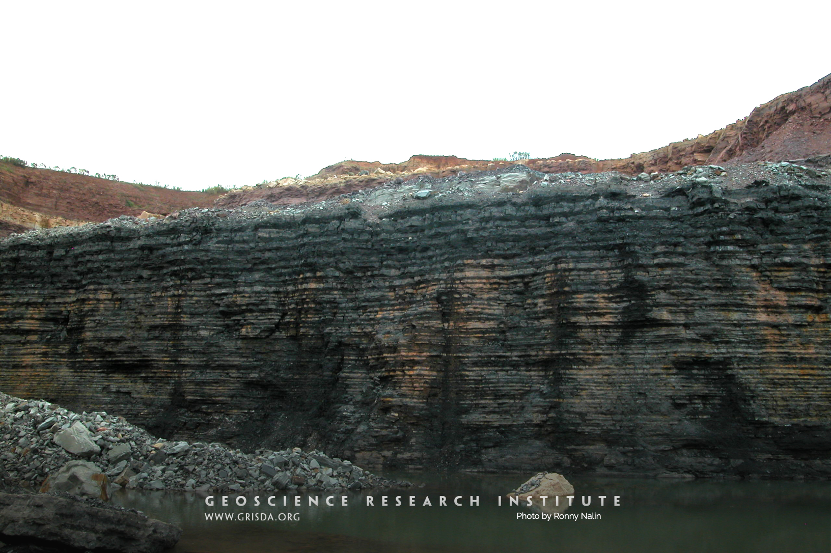
Cyclical bedding
Cyclical bedding with alternating beds of black shale and dolomite. Permian Irati Fm., Brazil. A thickening-upwards of the beds is distinguishable. High-frequency cycliclity is one of the many patterns can be found in the sedimentary record. Vertical face is about 3 meters high.
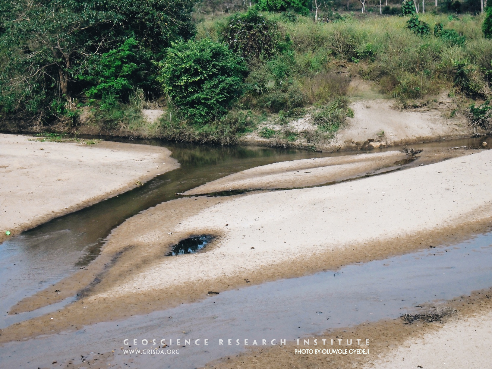
Siltation
After a flooding event, when waters are carrying much suspended sediment, the bed of a river can suffer siltation, becoming extensively covered by relatively fine-grained particles. This picture shows an example of this process from southern Nigeria.
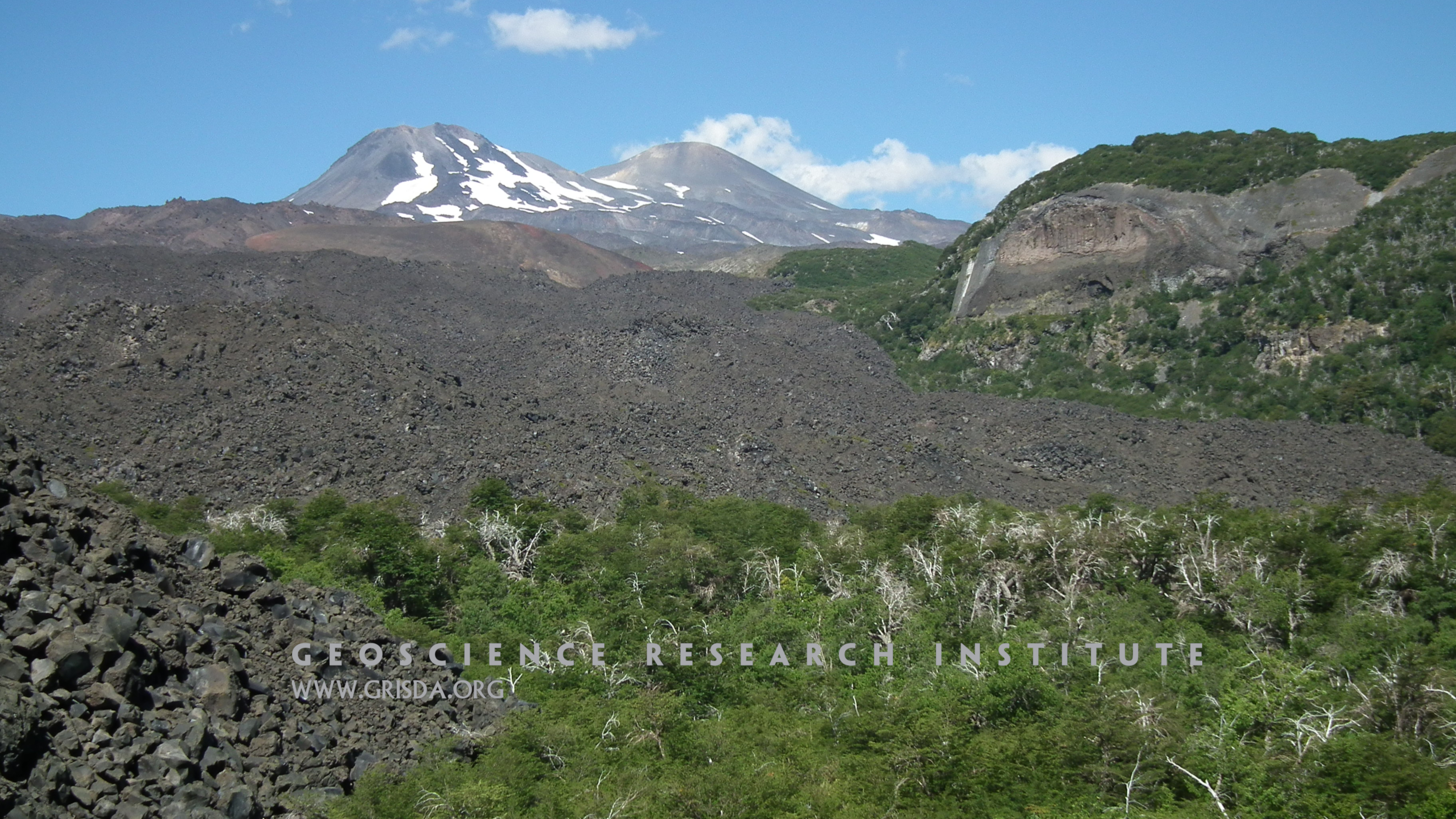
Nevados de Chillan
Basaltic rubble at the front of a lava flow with the stratovolcanoes of the Nevados de Chillan, Chile, in the background.
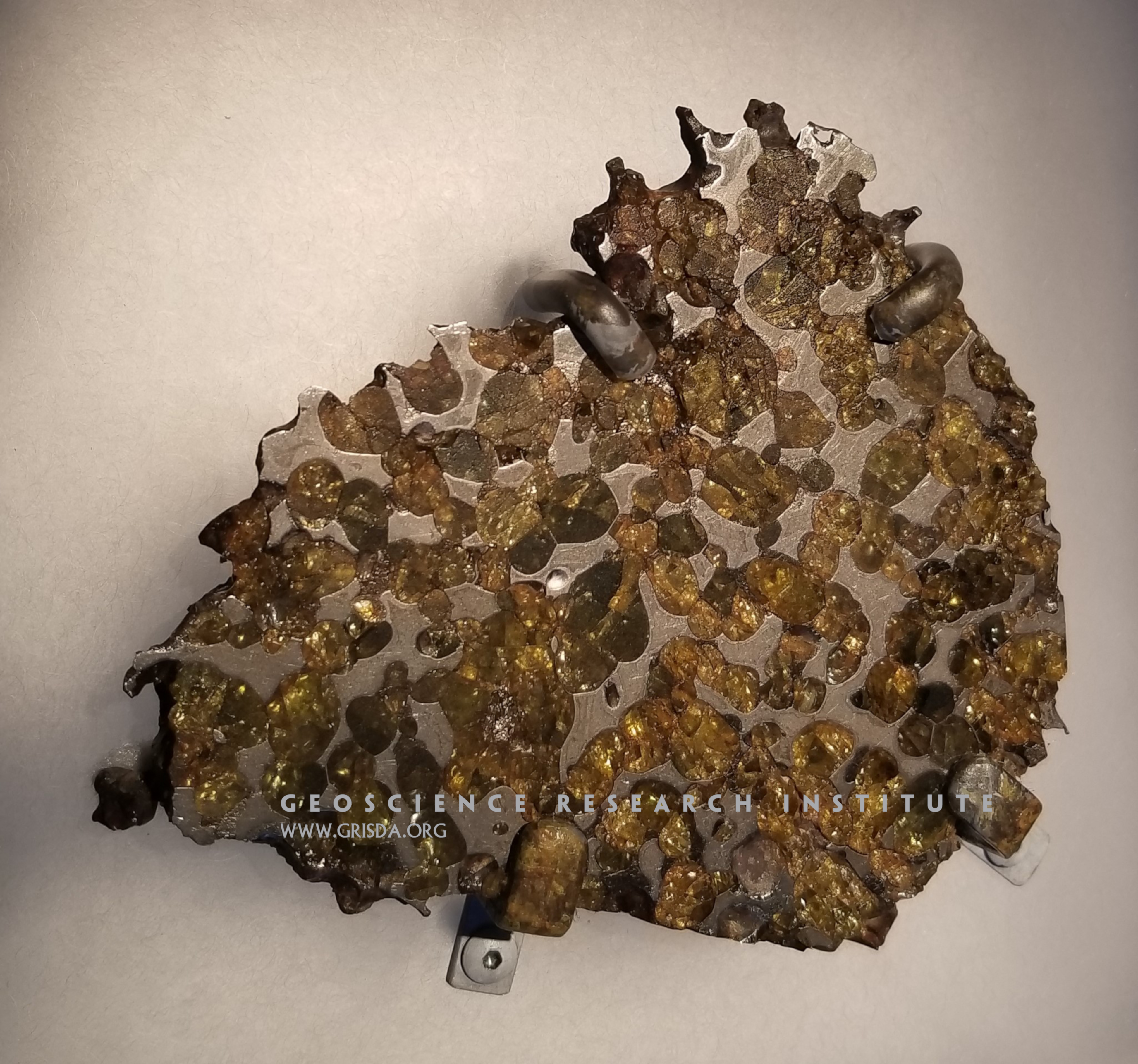
Pallasite
Meteorites are fragments of solid material coming from space, found on earth after surviving passage through the atmosphere. There are two general categories of meteorites: stony meteorites and iron meteorites. However, stony-iron meteorites also exist. For example, the meteorite in this image shows olivine (a silicate mineral) embedded in an iron-nickel matrix. This type of meteorite (known as pallasite) was found in the Thiel Mountains of Antarctica. Specimen on display at the Chicago Field Museum of Natural History.
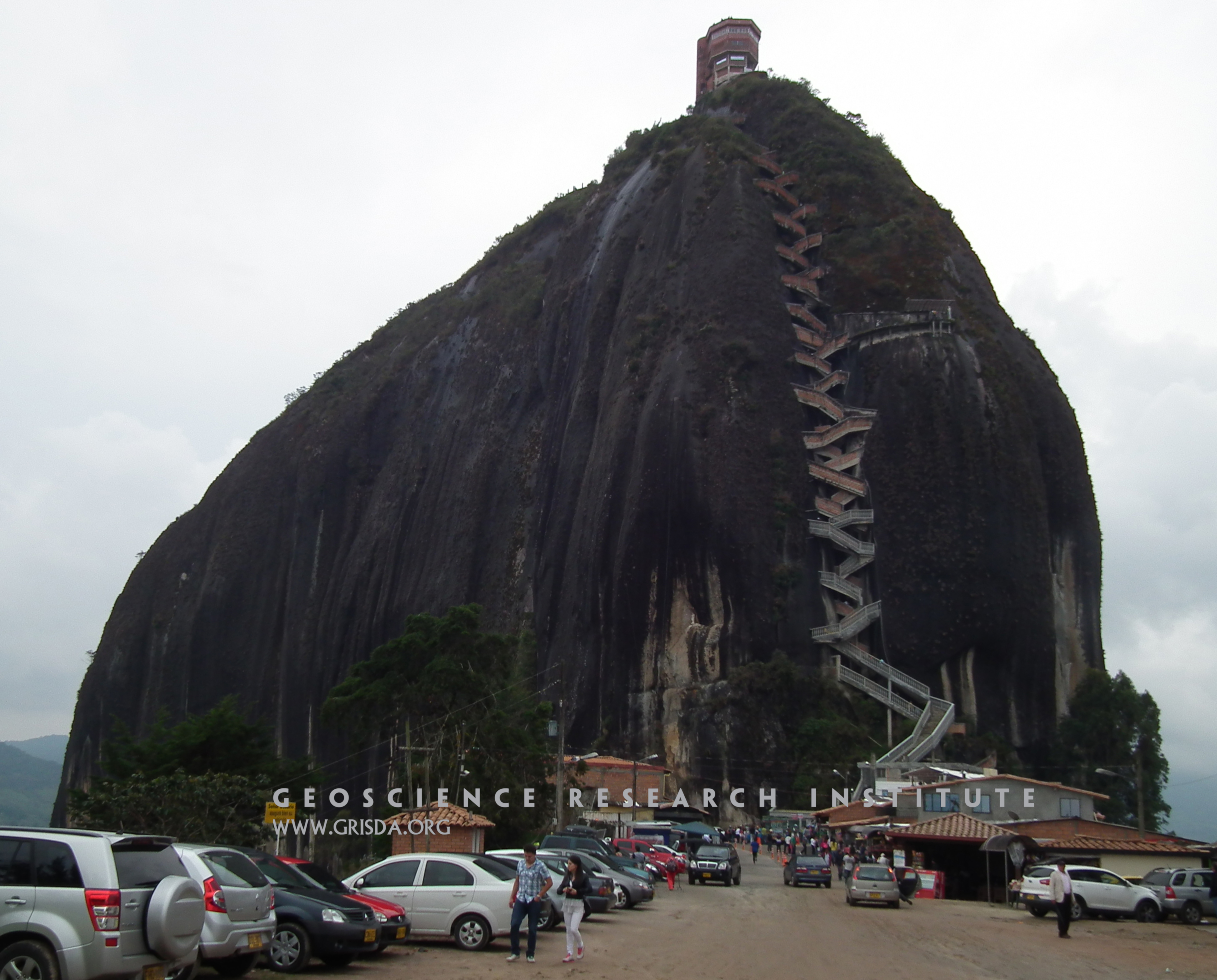
El Peñón de Guatapé
El Peñón de Guatapé is a granitic monolith that rises about 200 m above the surrounding landscape, in the Antioquia region of NW Colombia. These isolated landforms are also known as "inselbergs" and are typical of granitic rocks in tropical regions.
Great Unconformity_2
View of the contact between Precambrian basement and the Cambrian Sawatch Quartzite (marked by the tree line, mid-way through the picture), in the vicinity of Glenwood Canyon, CO, US. This important contact, an erosional discontinuity called "the Great Unconformity," is found over large sections of the North American continent.
Ripple cross-lamination
Cross-sectional view of a calcareous mudstone to fine-sandstone bed, showing planar lamination passing upward to ripple-cross lamination. The symmetric shape of the ripples, the presence of foreset laminae dipping in opposite directions, and some lamina draping suggest that the cross-lamination was likely generated by wave-ripples. The sequence from planar lamination to ripple cross-lamination can be indicative of decreasing velocity of bottom currents (or changes in sediment grainsize and supply rate). Diameter of lens cap is 6 cm. Photo taken at the I-70 roadcut, near Morrison, Colorado (Cretaceous Dakota Group).
Sandstone
Thin section microphotograph (in cross-polarized light) of a poorly sorted sandstone from Pliocene strata of the Sorbas Basin, Spain, containing lithic fragments of metamorphic rocks and gypsum clasts. The high birefringence colors of muscovite contrast with the gray colors of quartz. Field of view is several cm wide.
Wave ripples
Wave ripples in surface view (scale is 40 cm long). The crests are straight and regularly spaced. However, the overlying thin layer (top of the picture) shows a more disorganized pattern, partly reflecting the underlying crest orientation but probably indicating changing wave conditions. The preservation of these bedforms (that typically form in shallow water) can help to reconstruct the environment of deposition of sedimentary layers. Outcrop of the Cretaceous Dakota Sandstone, exposed along Dinosaur Ridge, Golden, Colorado.
Raindrop impressions?
These circular impressions, exposed on the underside surface of a layer of fine sandstone, have been interpreted as raindrop impressions. Sedimentologists have cautioned that similar impressions can form in muddy substrates by the ascent of bubbles through the sediment, or by interaction with air bubbles trapped in the overlying fluid. Scale in cm. Outcrop of the Maastrichtian Laramie Fm., exposed along the Triceratops trail Golden, CO, US.
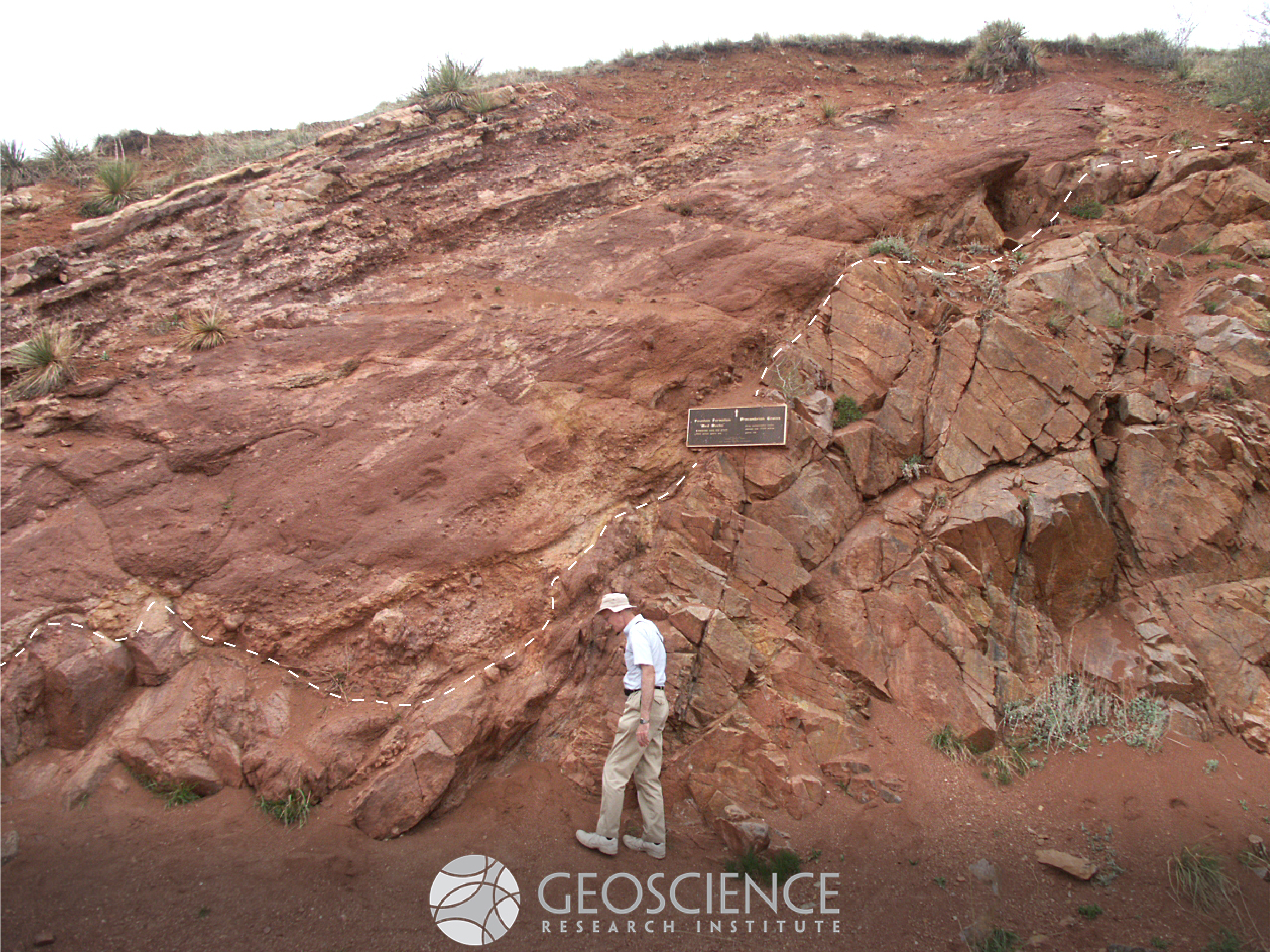
Nonconformity
A "nonconformity" is a type of discontinuity surface where sedimentary rocks lie above crystalline rocks. The dashed line in the picture marks a nonconformity between the Mesoproterozoic Pikes Peak Granite (bottom/right) and the Pennsylvanian conglomerates of the Fountain Formation (top/left), near Denver, CO. The contact in this outcrop (near Red Rocks Amphitheater) is marked by a plaque.
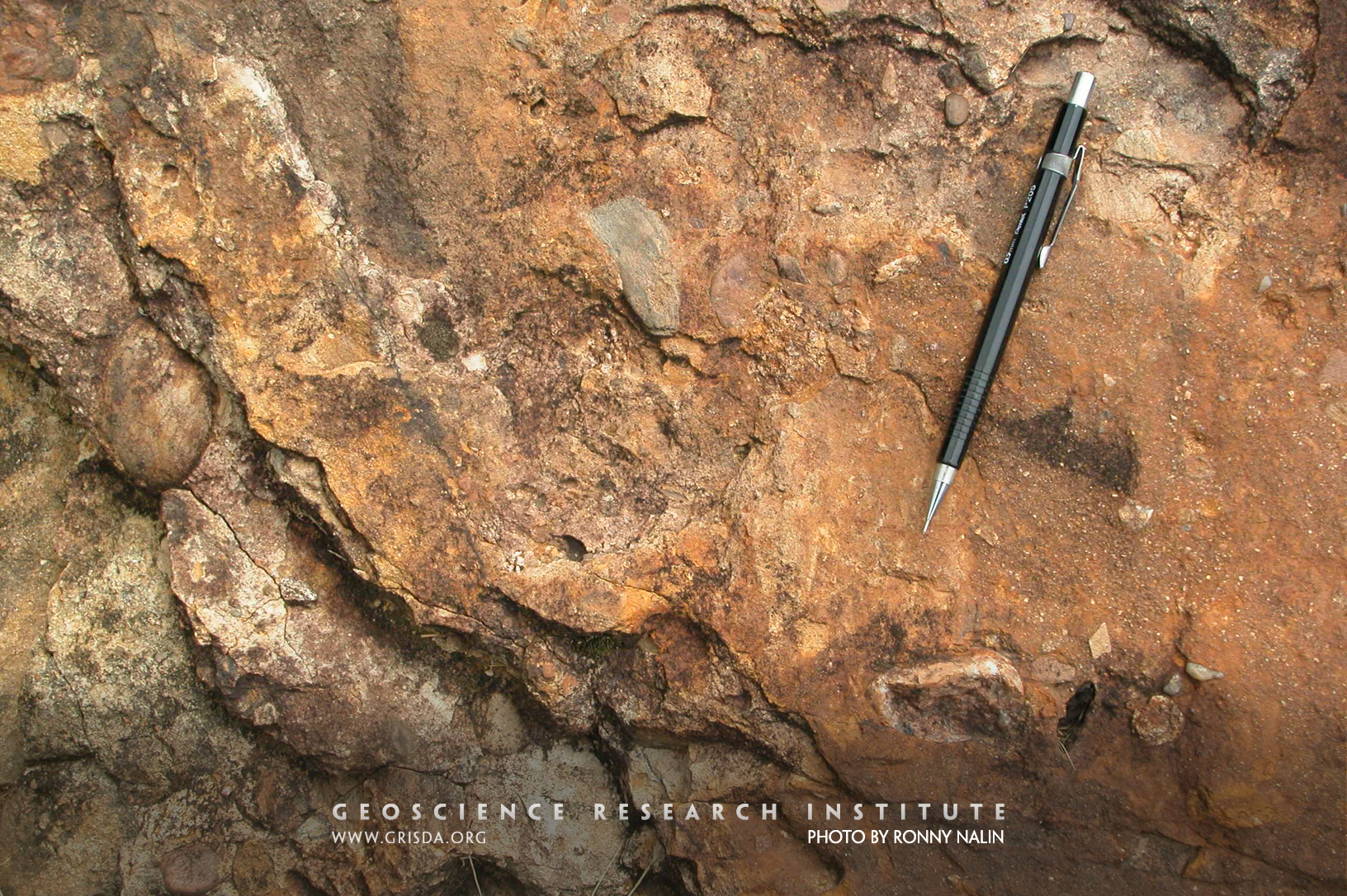
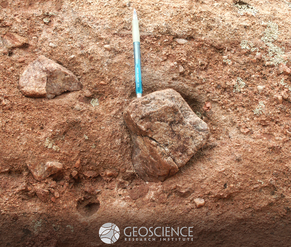
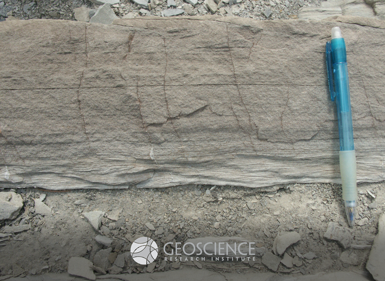
Principle of inclusion
One of the basic principles of stratigraphy is the "principle of inclusion." The principle states that if fragments of a rock unit are found included in a second rock unit, the second unit is younger than the first. In this picture, fragments of the Mesoproterozoic Pikes Peak granite (like the clast on which the pencil is resting) are included in a conglomerate layer of the Pennsylvanian Fountain Formation, CO. We infer that the granite must have existed as a solid rock body that was broken and eroded before and during the deposition of the conglomerate layer. Therefore, this principle helps establishing a relative sequence of events. The principle was already understood by Nicolas Steno, the father of stratigraphy. In his "Prodromus," published in 1669, he writes: "these same bodies had already become hard at the time when the matter of the earth and rock containing them was still fluid. And not only did the earth and rock not produce the bodies contained in them, but they did not even exist as such when those bodies were produced in them” (pp. 15-16).
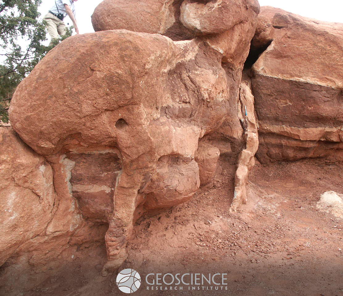
Clastic dykes
Clastic dykes are sedimentary features consisting of seams of sediment truncating the surrounding host rock or deposit. These dykes can form through different processes. For example, fluidized sand can be injected through fractures, cutting through underlying and overlying deposits. Alternatively, pre-existing open cracks can be passively infilled by accumulation of a different kind of sediment. This picture shows three sub-vertical sandstone dykes, with parallel orientation, cutting through sub-horizontal mudstone and sandstone layers of the Pennsylvanian Fountain Formation, at the Balanced Rock site of Garden of the Gods Park, CO. Although different interpretations have been presented to explain the dykes in this outcrop (e.g., infill after thermal contraction of unconsolidated deposits in a cold environment), fieldwork by GRI scientists suggests that they should be interpreted as injection features, possibly related to seismic activation of small normal faults. Pencil for scale (resting vertically on right dyke).
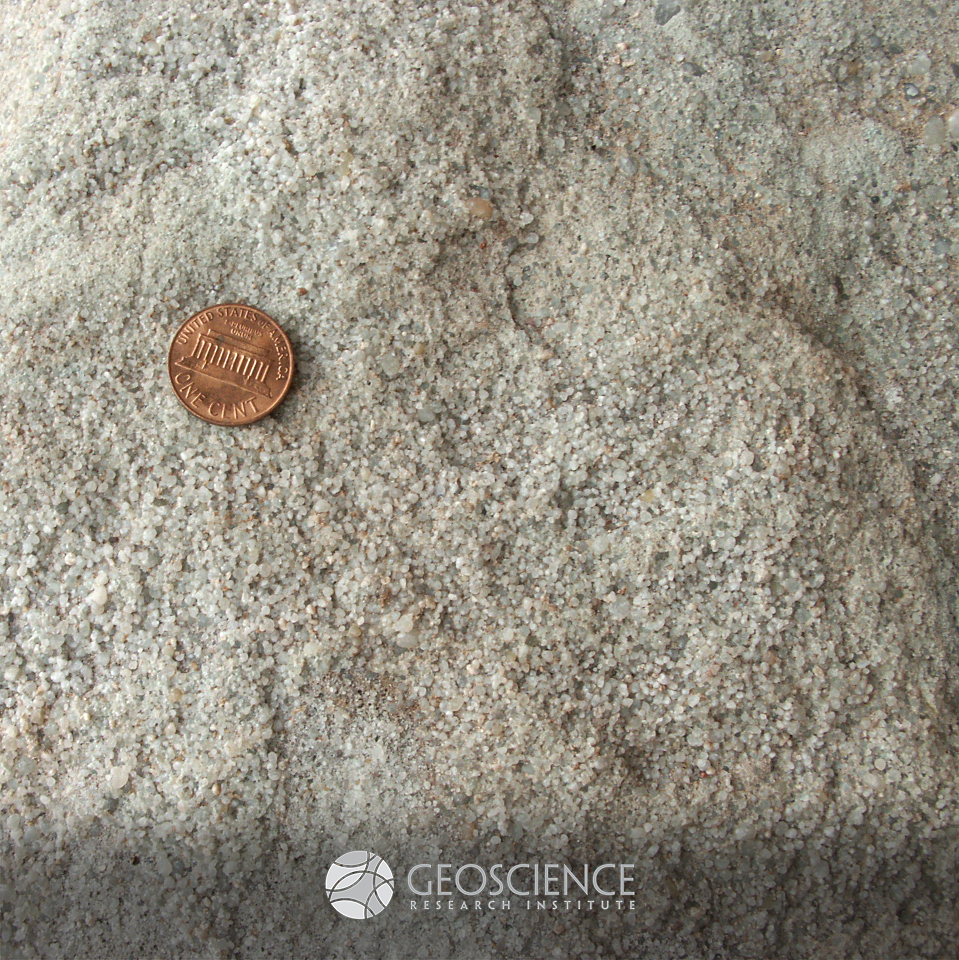
Cambrian quartzite
This sandstone, made up mostly of quartz grains, is an example of Cambrian quartzite. This type of deposit is very widespread in North America (and in other areas of the world), where it blankets the "Great Unconformity," the erosional surface marking the contact between crystalline basement and overlying sedimentary rocks. Sawatch Formation, vicinity of Colorado Springs, CO, USA
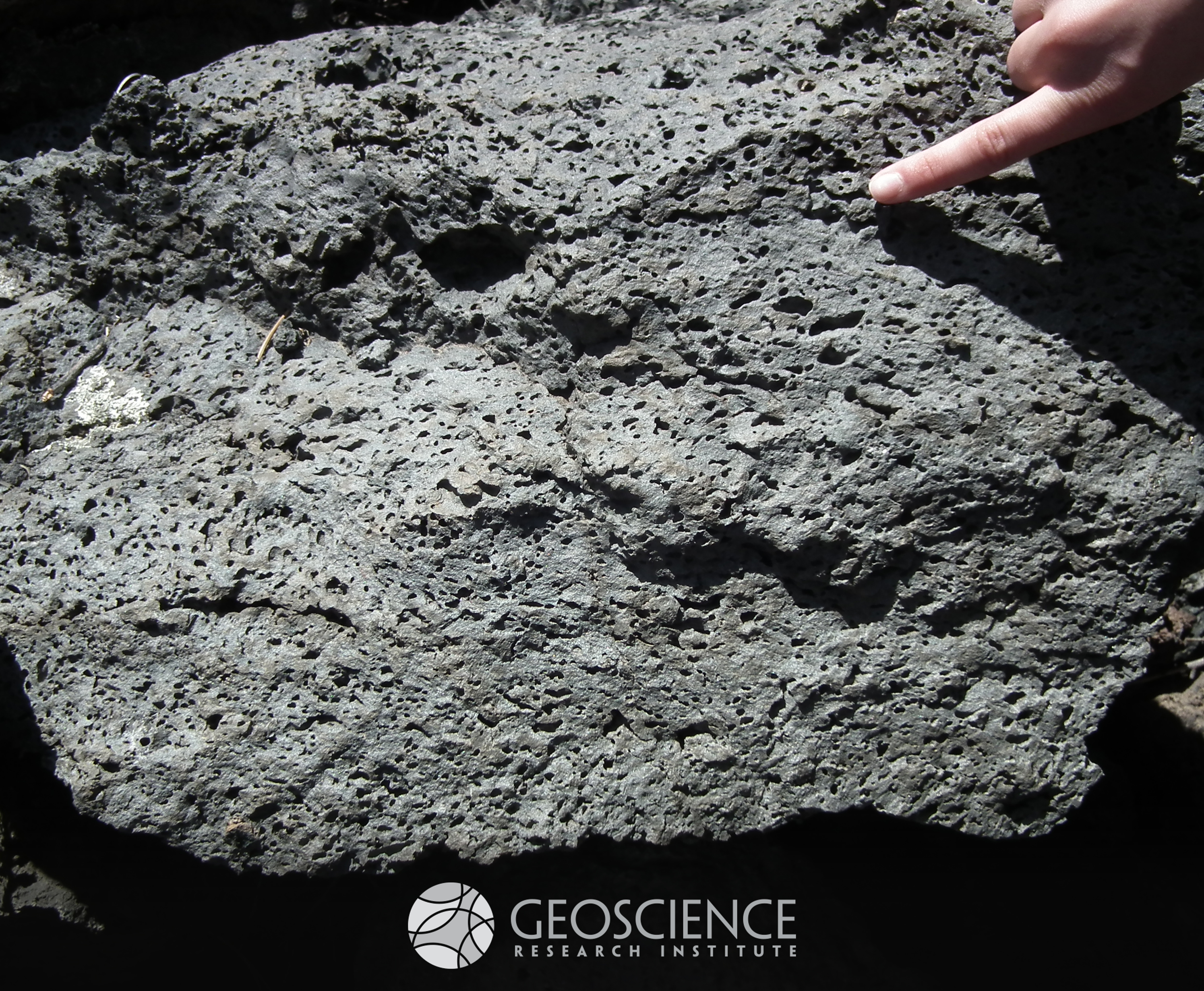
vesicles
Elongate vesicles in basalt from the Bonito Lava Flow, west of Sunset Crater, AZ. Gas bubbles trapped in the lava originated these cavities, with the stretching related to a preferential direction of flow. This example of volcanic activity is about 1,000 years old, and is part of a larger Volcanic Field (San Francisco Volcanic Zone, AZ, USA).
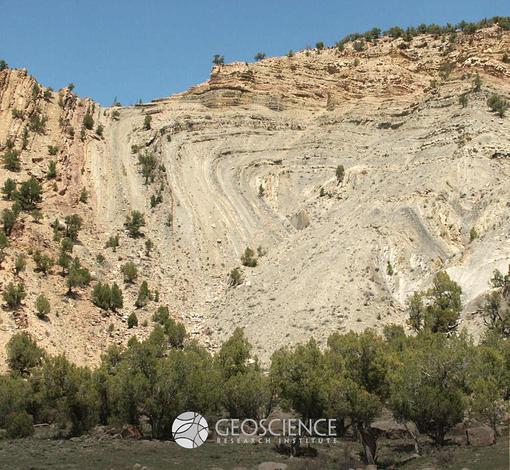
Recumbent anticline
Anticlinal folding in Pennsylvanian strata of the Belden Fm. (Sweetwater Creek, near Dotsero, CO). Monoclinal to recumbent folds (similar to this one) can be caused by displacement connected with the termination of a thrust fault buried at depth. Some have interpreted this particular fold in this way, linking it with thrust activity during the Laramide orogeny. Note that the lithology of the Belden Fm., which consists of bedded shales, limestone, and evaporites, favors ductile deformation. Layers that tend to resist plastic deformation under stress are termed "competent," and a contrast between competent (e.g., sandstone, chert) and less competent (e.g., shale, gypsum) beds can produce spectacular folding.
Hyperpycnite
You may have heard of turbidites. This type of deposit forms from pulse-like flows, where sediment travels rapidly down a slope because of a gravity contrast with the surrounding fluid. Turbidites typically show an upward decrease in gain size and a vertical succession of structures (massive/planar laminated/ripple cross-laminated) indicative of decreasing energy of the flow. There are, however, some deposits that differ from turbidites by showing a symmetric internal organization, with increasing and then decreasing grainsize, and with structures pointing to increasing and then decreasing energy of the flow. Hyperpycnites are such kind of deposit, forming when a river, laden with sediment during its flooding stage, flows into a basin. The flow typically waxes, reaches peak strength, and then wanes. Therefore, the resulting hyperpycnite reflects the waxing and waning cycle in its internal structure. This picture shows a nice hyperpycnite from the Pennsylvanian Minturn Formation, near McCoy (CO, USA). The bed displays reverse grading in its bottom part and a gradual upward transition from ripple laminated, to planar laminated, to massive (waxing phase). The upper part of the bed shows normal grading and hints of ripple-cross lamination (waning phase).
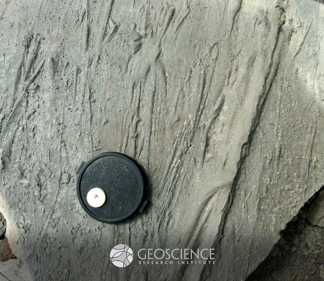
Sole marks
Sole marks are sedimentary structures found at the base of beds, best seen in surface view. They are typically preserved as casts of incisions/depressions created at the top of the underlying bed and filled with sediment of the overlying bed, often with a grainsize contrast between the beds (sand over mud). Sole marks are common in deposits of sediment gravity flows (like turbidites), where turbulence or bedload transport in an energetic flow can erode or leave marks on the underlying substrate in conjunction with active sedimentation. This picture, showing the base of a bed from the Pennsylvanian Minturn Formation, near McCoy (CO, USA), illustrates several kinds of sole marks: a) Flute casts, elongated scours with a wider round concavity at the upstream end, tapering to a pointed termination down current. Flute casts are formed by turbulent eddies in the flow and are excellent paleocurrent indicators; b) Prod marks, small irregular indentations, caused by particles suspended in the flow that occasionally hit the substrate; c) Groove casts, linear features, parallel to the current direction, formed by particles (like pebbles or sticks) dragged with the bedload and eroding the substrate. Prod marks and groove casts are sometimes called "tool marks," because they form as objects in the flow interact with the substrate. See if you are able to identify the three types of marks in the picture. In which direction do you think the flow was moving, towards the top or the bottom of the image? Lens cap for scale has a diameter of 6 cm.
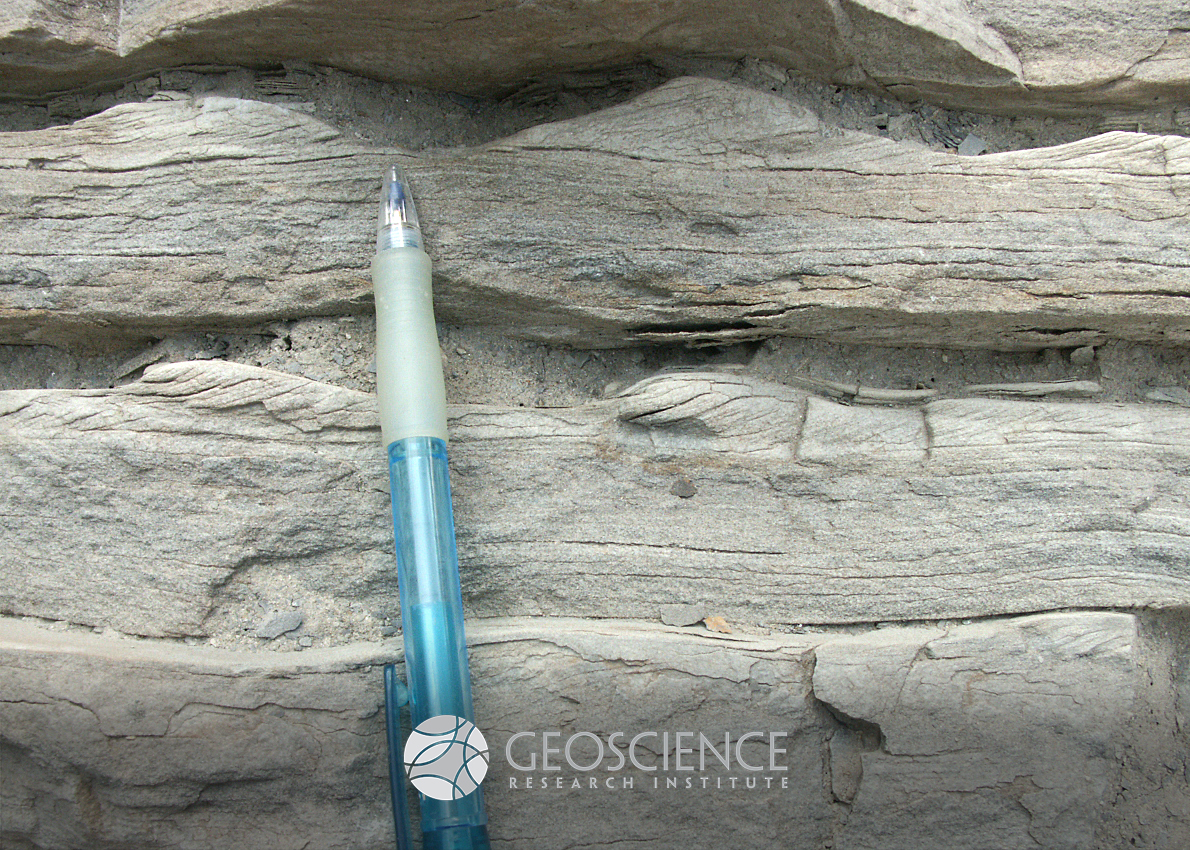
Bedforms
Bedforms are morphological patterns that form at the interface of flowing fluid and a bed of moving sediment. Typical examples include dunes and ripples. Lateral migration of bedforms can generate sedimentary structures, like ripple cross-lamination or cross-stratification. Geology students often mix up the concept of bedform and sedimentary structure: ripples are bedforms (not sedimentary structures) and ripple cross-lamination is a sedimentary structure (not a bedform). Sometimes, like in this picture of hyperpycnites from the Pennsylvanian Minturn Formation near McCoy (CO, USA), both sedimentary structure and associated bedform are preserved in a bed. The asymmetric profile of unidirectional current ripples (flow towards the left) and foreset laminae dipping to the left are clearly visible at the top of two consecutive sandstone beds, overlain by mudstone beds. Draping of bedforms by finer sediment indicates a decrease in hydrodynamic energy within a rapidly discharged, sediment-laden flow. Pencil for scale.
U-shaped valley
Characteristic U-shaped profile of a glacial valley. Broadening and flattening of the valley floor and steepening of the valley flanks are attributed to erosion by a glacier. After melting and retreat of the ice tongue, a U-shaped valley can be further modified by alluvial processes. Picture taken at Rocky Mountain National Park (CO).
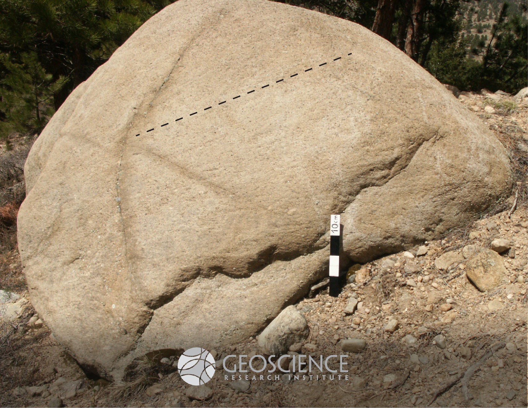
Striations
In glacial environments, rocks transported by ice can be grinded by friction with bedrock or other rocks. This physical abrasion can leave distinctive marks such as "facets" (flat, polished surfaces on clasts) and "striations" (linear grooves, typically parallel to the direction of ice flow). This faceted and striated boulder was photographed at Rocky Mountain National Park (CO), within glacial moraine deposits. Dashed line added to indicate main orientation of striations. Scale in 10 cm increments.
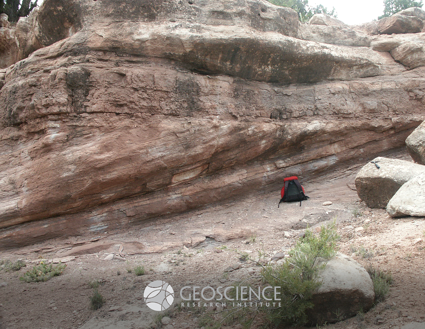
Clinostratification
The principle of original horizontality is one of the basic principles of stratigraphy. It states that sediments are deposited in essentially horizontal layers, and it was enunciated already by Steno in his Prodromus (1669, p. 30): "...adeoque strata omnia praeter infimum duobus planis horizontis parallelis contineri" (...all strata, therefore, except the lowest, were bounded by two planes parallel to the horizon). There are, however, exceptions to this principle. Strata can be deposited at an angle when sediment is being transported over a sloping substrate. This occurs, for example on the stoss face of sand dunes, on fluvial bars, or, at an even larger scale, on the front of submerged deltas. This type of stratification is known as "clinostratification" and the inclined layers or laminae are called "foresets." This picture shows nice clinoforms (foresets dipping to the left) overlain by horizontal beds, in the Pennsylvanian Minturn Formation (CO, USA). Backpack for scale, about 50 cm in size.
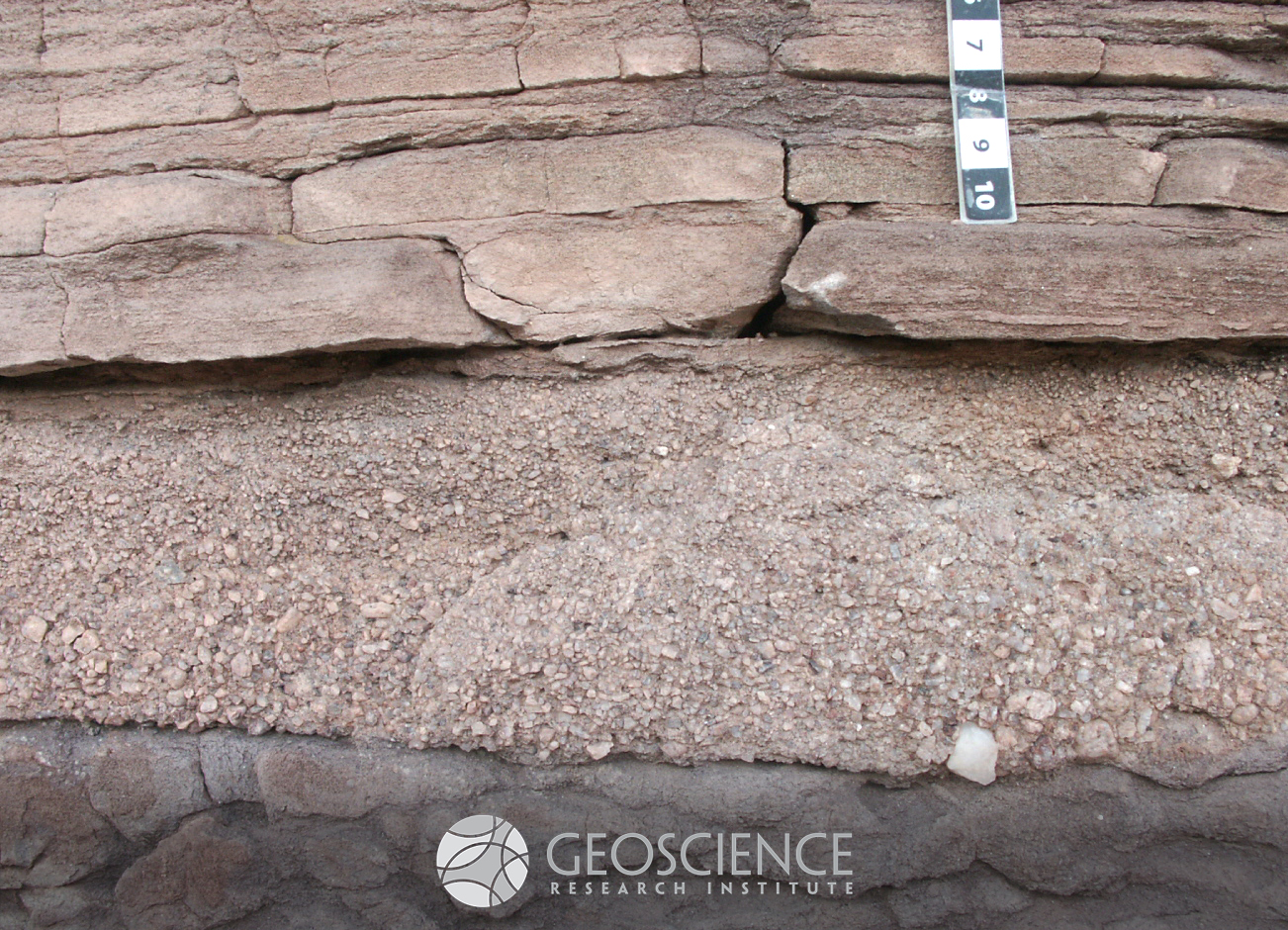
Normal grading
Normal grading is a type of arrangement of particles in a sedimentary bed, where coarser grains lie at the bottom and finer grains at the top, resulting in a general fining-upward size distribution. Several physical processes can produce normal grading, but most commonly it is indicative of a decrease in the energy of the flow transporting the particles. The bed in the lower half of this picture shows normal grading from microconglomerate angular pebbles to granules to coarse sand at the top. Pennsylvanian Minturn Formation (CO, USA), scale in cm increments.
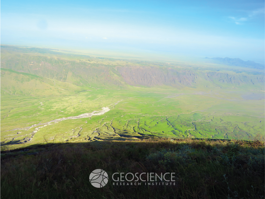
Rift
Splitting apart Africa: The East African Rift System or Great Rift Valley is one of the best examples of a divergent plate boundary on land in the popular tectonic plate model. It extends almost 6000 km southward from the Afar triple junction between northern Ethiopia and the Arabian Peninsula through eastern to southern Africa, effectively splitting Africa into two separate plates. This results in thin crust with a high flow of heat from the Earth’s interior as well as a series of deep elongated lakes called ribbon lakes, such as Lake Tanganyika and Lake Malawi. The thin crust also results in numerous volcanoes, erupting lava, or molten magma that reaches the Earth’s surface, by a process called decompression melting. The pulling apart of continental plates creates a zone of low pressure that melts the earth’s crust and pulls the magma upwards. The weakened and fault riddled rift zone allows magma to reach the surface and erupt as volcanoes. Photo by Ben Clausen.