by Arthur V. Chadwick Assistant Professor of Biology, Loma Linda University and Leonard R. Brand Chairman, Department of Biology, Loma Linda University
The Chinle formation in the Southwestern United States offers interesting opportunities to do research important to the interpretation of the past. The project reported here was first conceived during an institute for secondary biology teachers conducted by the Loma Linda University Biology Department in 1970. At that time Harold G. Coffin of the Geoscience Research Institute conducted a paleontological field trip and suggested that a study on fossil tree orientation may enhance a better understanding of the events associated with the deposition of the Chinle formation. The orientation of fossil trees and other fossils can provide information on the direction of flow of water during deposition. Such information should be useful in constructing models of geologic action during the Genesis flood and subsequent geologic events.
The following is a preliminary report describing the intent, nature and extent of the initial work on this project, conducted during the past two years by staff and graduate students of Loma Linda University and secondary-school teachers.
The Chinle formation outcrops frequently in Utah and Arizona. It is best known from the Painted Desert region where its striking displays of reds, greys, tans, yellows and lavender are prominently displayed. Better known than the formation itself are the countless petrified trees found within it, primarily in the lower Petrified Forest member. This member is perhaps best characterized as a shaly marl which weathers into mounds exposed as sparsely vegetated badlands.
There is little question that the deposition of the Chinle formation resulted from flowing water on a grand scale. Almost all of the features described in the Chinle are interpreted as features compatible with a broad flood plain. The trees are generally described as having been transported in by flood conditions from source areas outside of the sedimentary basin. Signs of water wear are frequently described in connection with the logs [6]. In some areas leaf-twig compressions are found and occasionally fossil twigs and branches replaced with iron pyrite can be found. At present the fossil flora consists of about 50 species of 41 genera [2].
Most of these are known from scattered occurrences. Only a single species (Araucarioxylon arizonicum), a gymnosperm tree, is found in great abundance as well-preserved specimens. It is this species which comprises most of the petrified logs of the Chinle.
Occasionally reports have been made of tree stumps in "position of growth" within the formation. The earliest reports recorded by Ward [4] describe an area northeast of Cameron, Arizona, in which twenty stumps are so positioned. Other areas within the Petrified Forest National Park also contain upright stumps, although these are generally smaller in diameter. We recently relocated the area described by Ward and found several apparently upright. These stumps have created somewhat of a problem for the traditional explanation of Chinle deposition but have generally either been ignored or considered as occasional trees which took root in sand bars on flood plains [3]. Seldom is great effort expended to determine whether trees which appear to be upright grew in position, since no other explanation is apparent. It is a little known fact that tree trunks, particularly the bases of trees, float in upright position in water after a period of time [1], [5]. Under the right conditions these could easily become buried in that position. We partially excavated two of these trees to the apparent root level. There was no stratigraphic break associated with the base of these trees which could be interpreted as "soil." This suggests that they may be of allochthonous origin (transported to the site of deposition), rather than in position of growth.
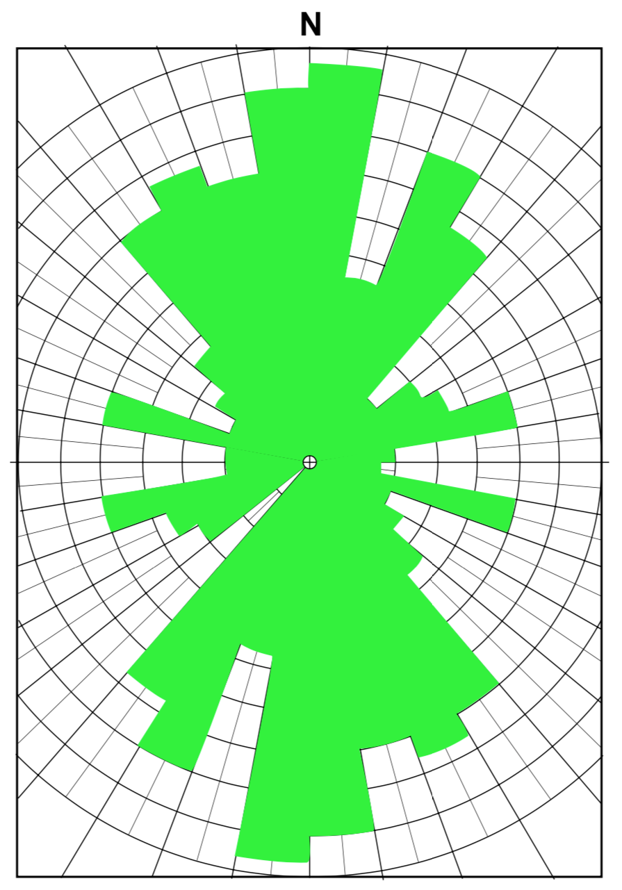
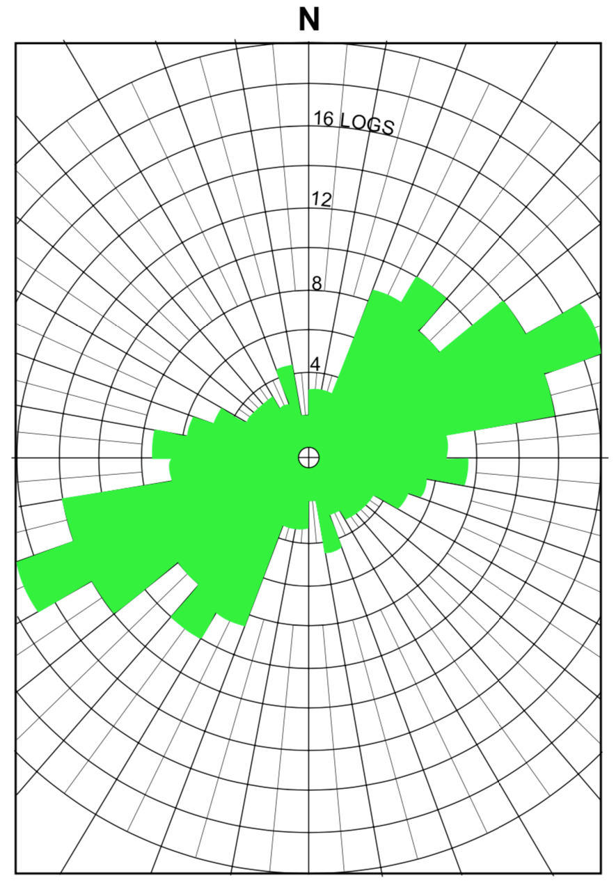
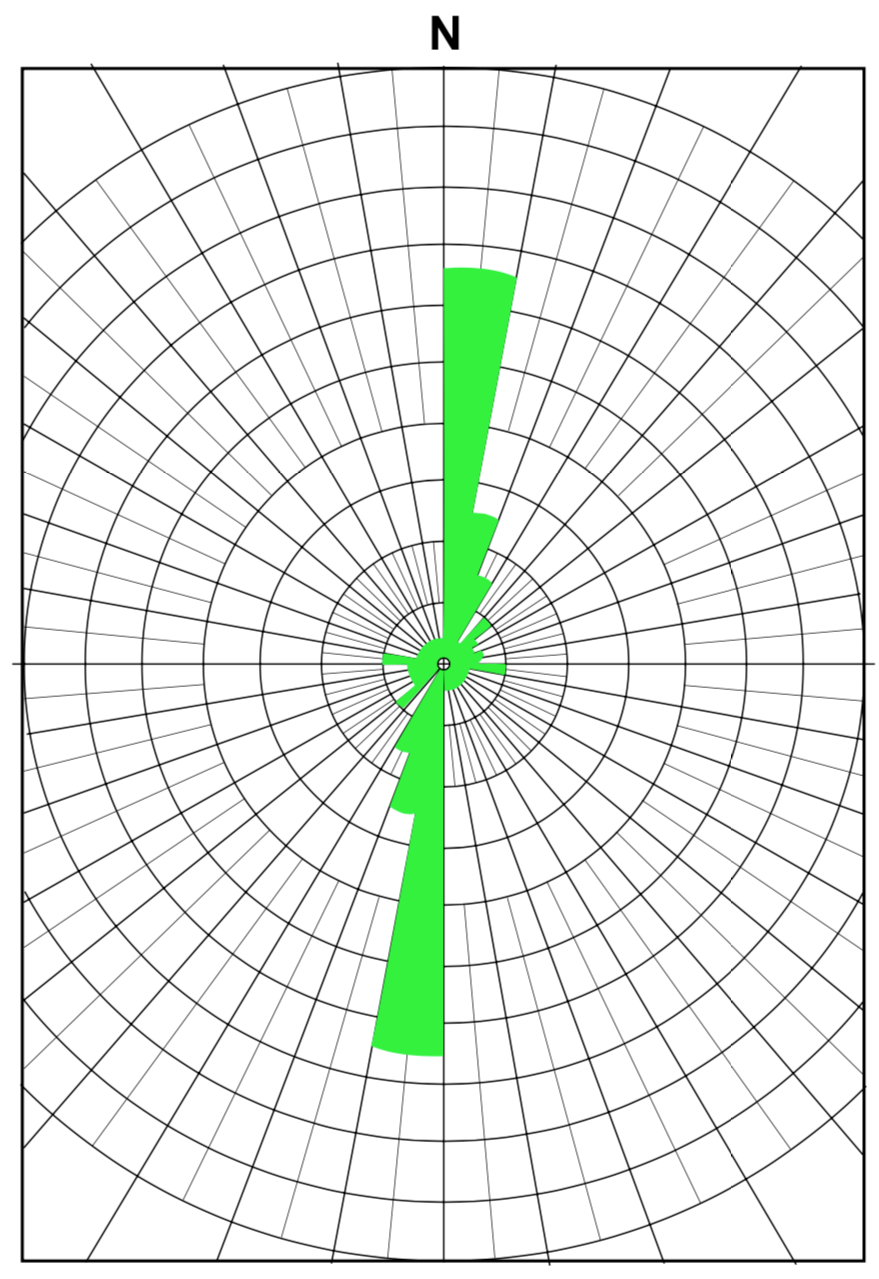
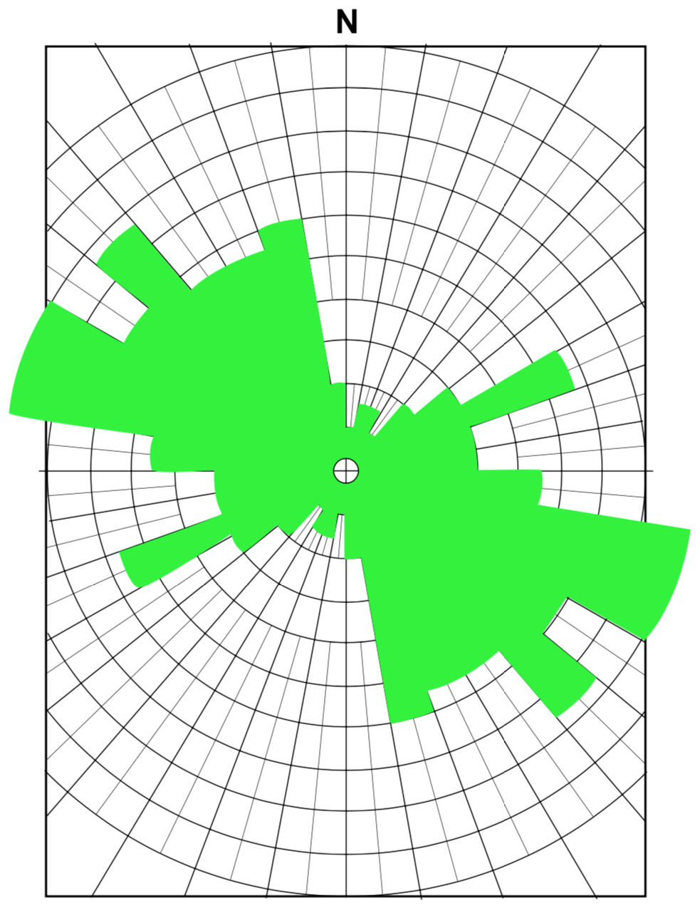
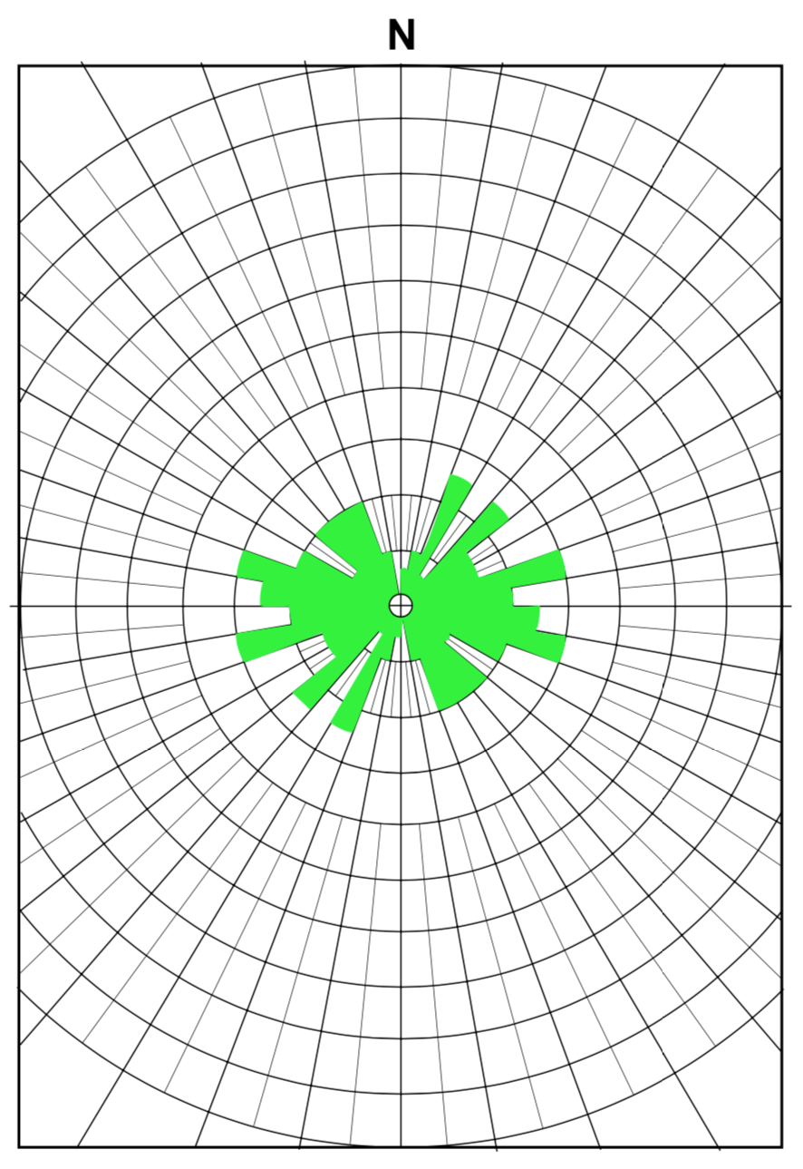
Regarding the allochthonous origin of the prostrate logs, there is little dispute. However, very often the logs are interpreted as being borne in rivers and streams to their present position [3], [6], but other explanations are also possible. A model has been developed which could account for the allochthonous origin for the petrified logs without doing violence to the evidence of uniform sedimentary emplacement. This model involves the sedimentation of tremendous quantities of volcanic ash (of which the Petrified Forest member is largely composed) in a body of water resulting from the Genesis flood. Trees rafted in from a forest devastated by the flood became stranded in the volcanic mud as the waters ebbed and flowed in the basin. Subsequent deposition completed the process of emplacement. Data on tree orientation in many localities will be useful in developing this model. It is well known that objects in flowing water align themselves in the direction of least resistance to flow. For elongate objects such as tree trunks this means they will tend to orient parallel with the prevailing current. Thus the general alignment of logs should represent the average direction of the depositing current. Uniform orientation at each site would indicate flowing water, whereas random orientation would more likely result from logs sinking in a standing body of water. Strong correlation in orientation at different sites would indicate uniform flow of water over a large area, but differences in orientation from one site to another would suggest that local factors were important in directing current flow.
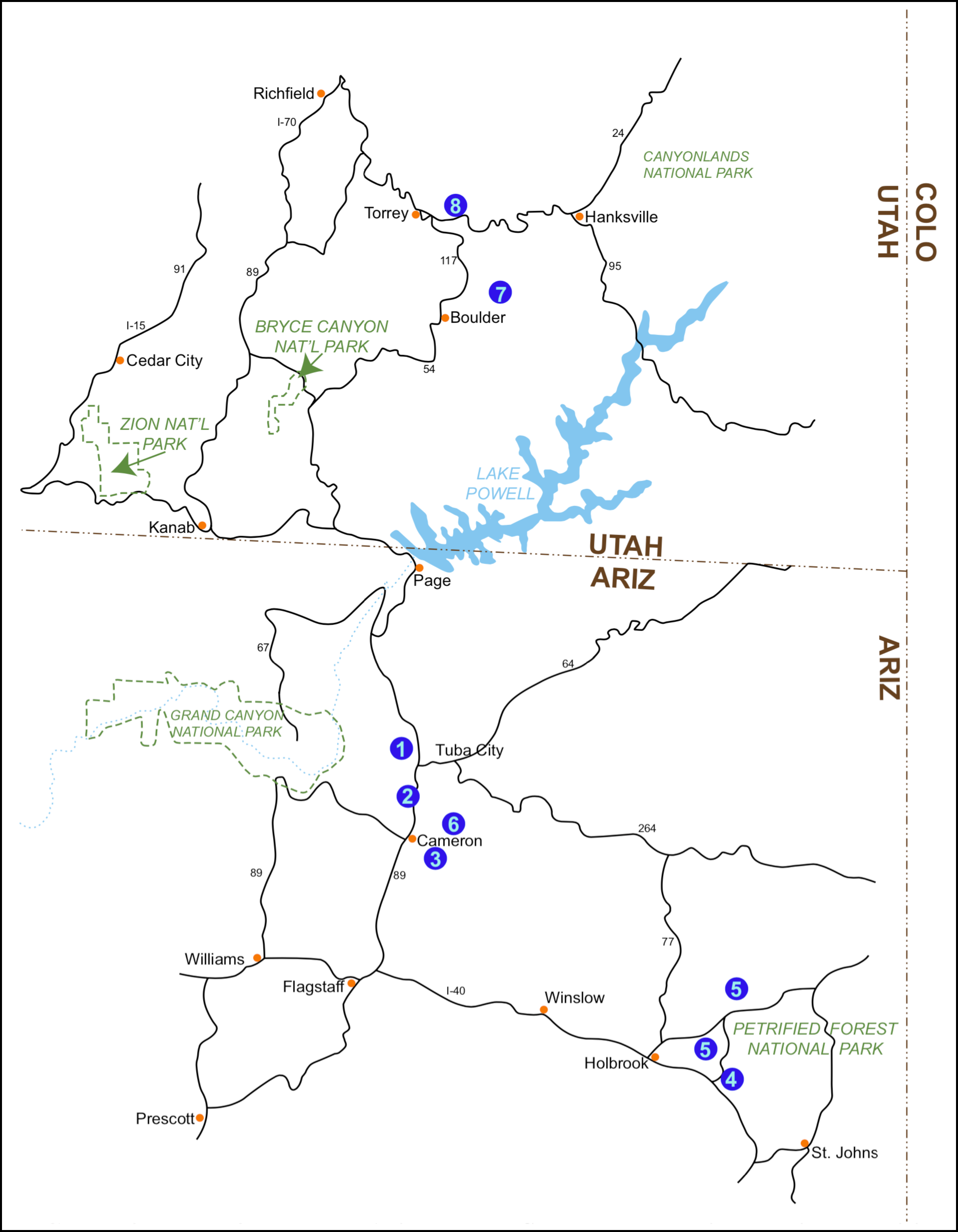
Trees were measured at nine locations in two general areas in Arizona and Utah with occasional scattered data points from other areas. Some attempts were made to determine the base end of the tree but very often this was not possible. In some studies lengths were recorded as an indicator of relative reliability. Longer trees tended to present a more parallel orientation pattern, although this was not always the case. Data points were obtained at the following locations (Fig. 9):
15 miles NW of Tuba City 36 trees
6 miles NNW of Cameron 45 trees
3 miles E of Cameron 80 trees
Petrified Forest National Park 176 trees
Black Forest and NW of Crystal Forest (data combined) 176 trees
NE of Cameron ½ mile N of site 3 27 trees
Capitol Reef National Monument on Chimney Rock trail 138 trees
Wolverine petrified wood area 61 trees
FIGURE 9. Map of Northern Arizona and Southern Utah, illustrating localities where orientation of fossil trees has been determined.
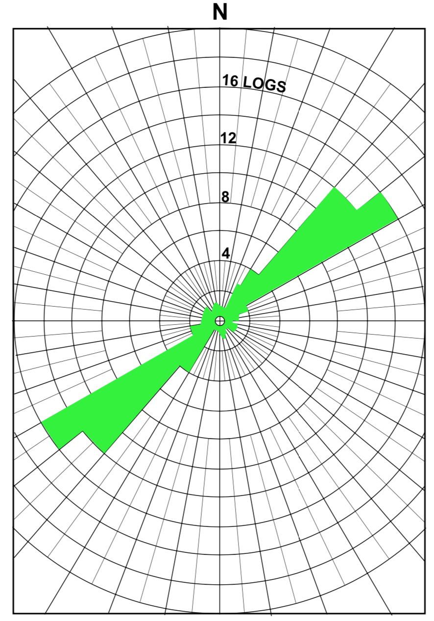
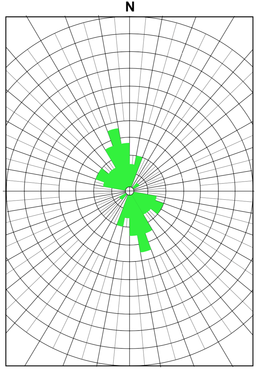
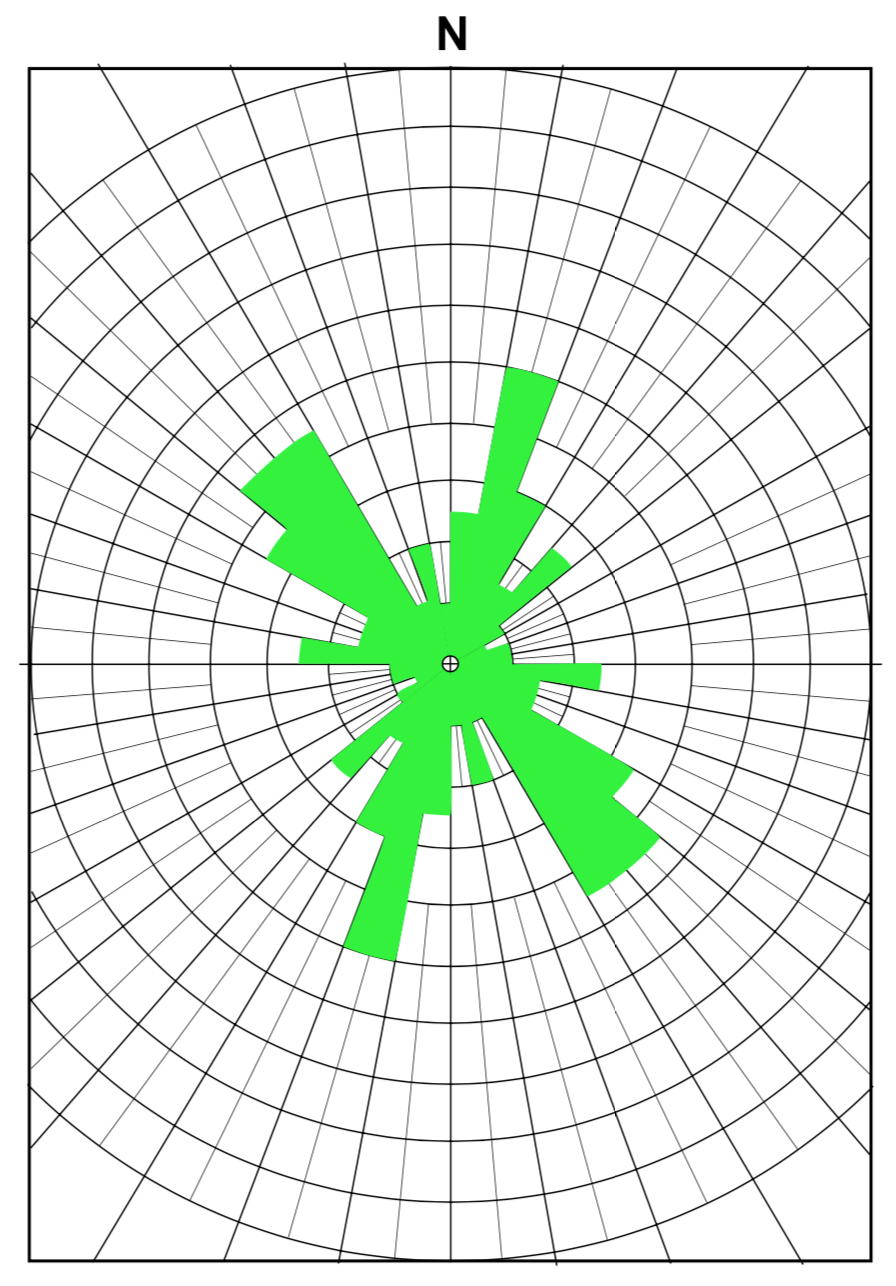
The orientation of 739 trees has been determined in 8 locations. The most variant data were obtained at the site 3 miles NE of Cameron. Here unusual difficulty was encountered in attempting to assign the logs to a particular stratigraphic horizon. It is felt that at least part of the variance at this site results from lumping the data from more than one stratum. At other locations, this was not a problem, since most logs were exposed at the surface in one horizon.
These preliminary data show very strong orientation of logs at most sites (Figs. 1-8). It is evident that before any far-reaching conclusions can be drawn, more data are needed. When these data become available, tree orientation may allow correlation with certain Paleozoic directional indicators in the same basin [7],[8].
Figure 1Figure 2Figure 3Figure 4 (FIGURES 1-4. Plots of orientation of horizontal logs at locations 1-4 respectively. Length of bars indicates the number of logs in each 10 degrees of arc. See figure 1 for scale.)
Figure 5Figure 6Figure 7Figure 8 (FIGURES 5-8. Plots of orientation of horizontal logs at locations 5-8 respectively. Length of bars indicates the number of logs in each 10 degrees of arc. See figure 5 for scale.)
Although this report deals primarily with the Chinle formation of the Southwestern United States, similar analyses need to be done in other areas on such phenomena as grain orientation, fossil orientation, ripple marks and other directional indicators.
It is important that individuals with training in science and a commitment to God's Word utilize that training in developing the necessary data input for evaluating a workable flood model. It is hoped that this initial effort will stimulate others to put forth reliable, careful efforts towards this goal.
ACKNOWLEDGMENTS
The authors wish to acknowledge the help of James Anderson, Harold Coffin, Gottfried Fritz, Art Kanna, Lanny Fisk, Berney Neufeld, Lance Hodges, Phil DeBord, and David Steen in gathering data on the trees.
REFERENCES
[1]Ager, Derek V. 1963. Principles of paleoecology. McGraw-Hill Book Co., Inc., New York. 371 pp.
[2]Ash, Sidney R. 1972. Plant Megafossils of the Chinle formation. Investigations in the Triassic Chinle formation. Museum of Northern Arizona Bulletin 47. 103 pp.
[4]Ash, Sidney R. 1972. The search for plant fossils in the Chinle formation. Investigations in the Triassic Chinle formation. Museum of Northern Arizona Bulletin 47. 103 p.
[5]Coffin, Harold G. 1971. Vertical flotation of Horsetails (Equisetum): geological implications. Geological Society of America Bulletin 82:2019-2022.
[6]Gregory, Herbert E. 1950. Geology and geography of the Zion Park region Utah and Arizona. U. S. Geological Survey Professional Paper 220. 200 pp.
[7]Hughes, Paul W. 1952. Stratigraphy of Supai formation, Chino Valley area, Yavapai County, Arizona. Bulletin of the American Association of Petroleum Geologists 36:635-657.
[8]McKee, Ed. 1940. Three types of cross lamination in Paleozoic rocks of N. Arizona. American Journal of Science 238:811-824.