The layers of sedimentary rock that we see over the surface of the earth usually appear as parallel features that are often spread over wide areas. What does not appear to the casual observer is that between some of these layers major portions of the stratigraphic (geologic) column are missing. These gaps between the layers tell a story related to the age of these layers.
Geologists can tell that a portion of the layers is missing because in other parts of the word layers with characteristic fossils are found between the layers represented at the gaps. For instance, near the bottom of the Grand Canyon, the Ordovician and Silurian portions of the geologic column are missing between some of the parallel layers present. The missing portion represents an assumed 100 million years of layers found elsewhere.
The crucial question is: Is there evidence of that 100 million- year gap, or does it appear that the layers were laid down rapidly, as would be expected during the flood described in the book of Genesis? If there really is a 100 million-year gap, evidence of this in the form of erosion should be abundant. In fact, current rates of erosion are so rapid that erosion would completely eliminate layers below the gaps in the time span assumed.
These gaps are common, and it appears that the erosion and other features expected during these long gaps in deposition are not there. This suggests that the layers were laid down rapidly. The absence of the expected evidence for long ages challenges the standard geologic time scale of thousands of millions of years for the formation of the strata of the earth.
THE GAPS (HIATUSES)
In the Panhandle region of Texas one can drive for many miles on the flat plain called the Llano Estacado or "staked plain." The origin of the name is somewhat obscure. Possibly it came from marker stakes left on the plain by pioneers or from cactus plants that resembled stakes.
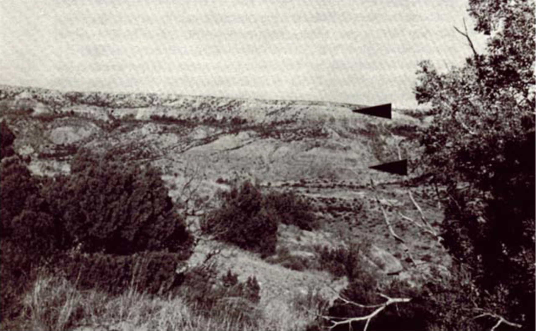
Dramatic geologic features come to view at the edge of the Llano Estacado. In Palo Duro Canyon, which has been eroded from the southeast, the layers below the staked plain are well-exposed (Figure 1). The top layer is the prominent, mostly light-colored Ogallala Formation, which is sometimes up to several hundred meters thick, although only about 30 m thick here. It extends for some 1200 km from South Dakota to well-south of the Texas Panhandle. Economically the Ogallala is very important, because it harbors water for the towns and farms of the region.
FIGURE 1. View of Palo Duro Canyon in northern Texas. The upper arrow points to an assumed 200 Ma gap in the sequence of sediment deposition. The lower arrow points to a 16 Ma gap.
Fossils that have been found in the Ogallala include horse teeth, plant roots (Maxwell 1970), a giant tortoise, fossil seeds (WTSU n.d., p. 18), and remains of mastodons, camels and sloths (Matthews 1969). Just below the Ogallala is the darker Trujillo Formation. Fossil wood, leaves and bones of an extinct amphibian have been found in this formation (Maxwell 1970). The upper arrow in Figure 1 points to the somewhat-indistinct boundary between these two formations.
According to the standard geologic time scale, the Ogallala is considered to be a very young formation about 2-5 million years (Ma) old (Pliocene). The Trujillo Formation is considered to be over 208 Ma old (Triassic). The top arrow in Figure 1 points to a gap of some 200 Ma of missing layers.
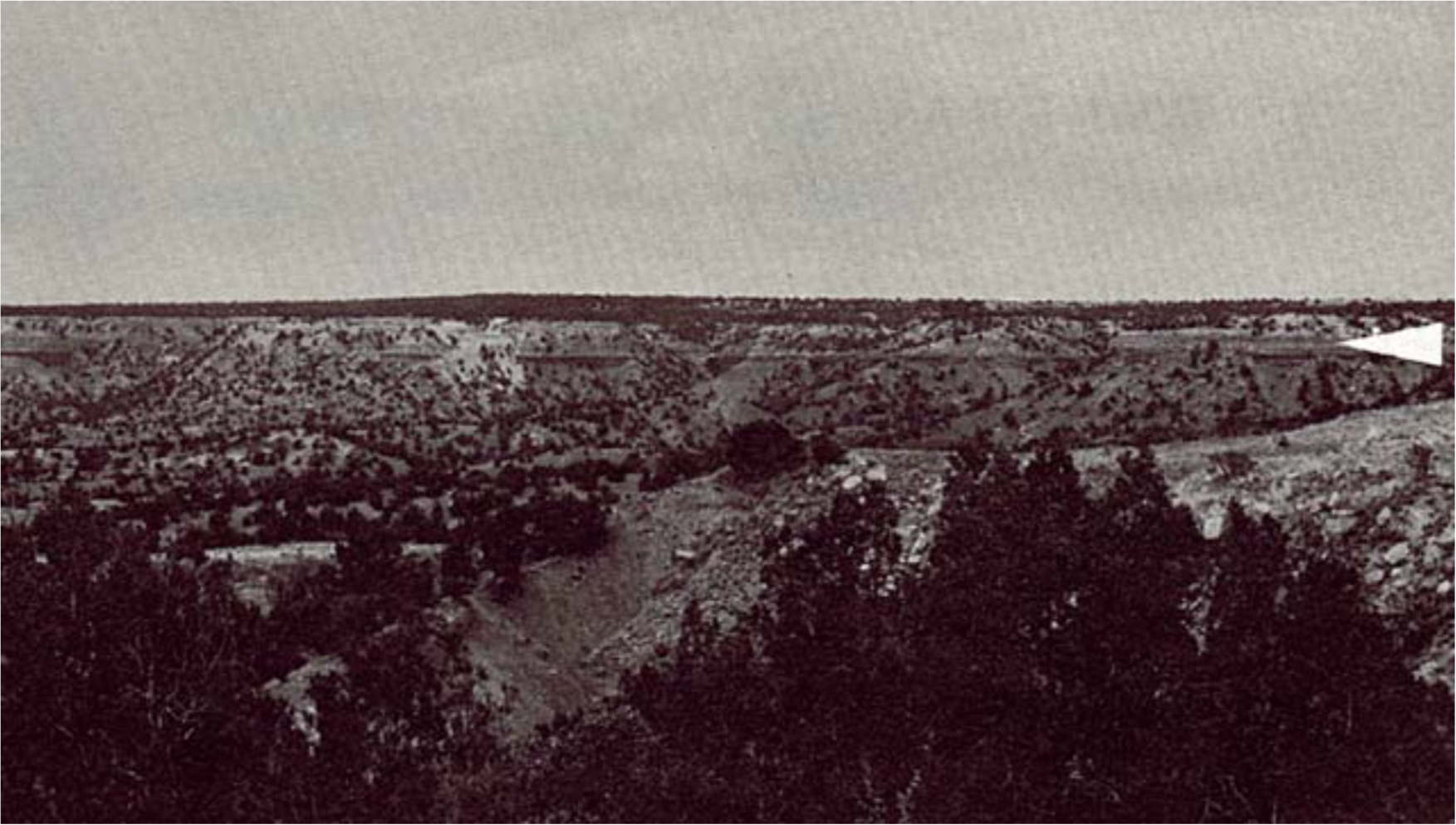
Approximately 150 km to the west (Figure 2), south of the town of Tucumcari, New Mexico, the same assumed 200 Ma gap is found. The arrow in Figure 2 points to the contact between the Triassic Chinle Formation and the Pliocene Ogallala above. Three-hundred km further south near the town of Big Springs, Texas, the same relation can be seen. To the north the assumed gap decreases gradually as layers younger than the Trujillo and Chinle underlie the Ogallala.
FIGURE 2. View of cliff south of Tucumcari, New Mexico. The same 200 Ma gap shown in Figure 1 is indicated by the arrow.
The proposed ages of these formations can raise a question about the validity of the geologic time scale. If there is a 200 Ma hiatus of layers between the Ogallala and the layers below, the effects of that extended time period should be noticeable. If not, one may wonder if it ever took place. Evidence for time should be especially manifest in the form of gullies, canyons, and valleys produced by erosion; weathering; plant growth; and soil formation. Sometimes there is evidence of slight erosion, but not what would be expected over the purported time suggested and is graphically demonstrated by Palo Duro Canyon itself. Could the Trujillo Formation remain so flat or be eroded to such flatness during these assumed 200 Ma, or has much less time been involved? As can be seen, the Ogallala lies very flat on top of the Trujillo. The Trujillo has many soft units that should be eroded away in relatively short periods of normal weathering and erosion. The question is especially pertinent when one realizes that this flat contact extends over approximately 150,000 km2.
A little lower in Palo Duro Canyon are two other formations that also have an assumed time gap between them. The lower arrow in Figure 1 points to that contact line. Above the arrow is the Late Triassic Tecovas Formation and below is the Permian Quartermaster Formation. The middle and lower Triassic layers are missing (2). While this represents only a 16 Ma gap in contrast to a 200 Ma gap above, it does represent a considerable time span during which much could have happened.
All of this raises a more fundamental question, namely: Do the assumed time gaps between sedimentary layers show the effects of time, or do they suggest rapid deposition as would be expected if they were laid down during the catastrophic flood described in the book of Genesis?
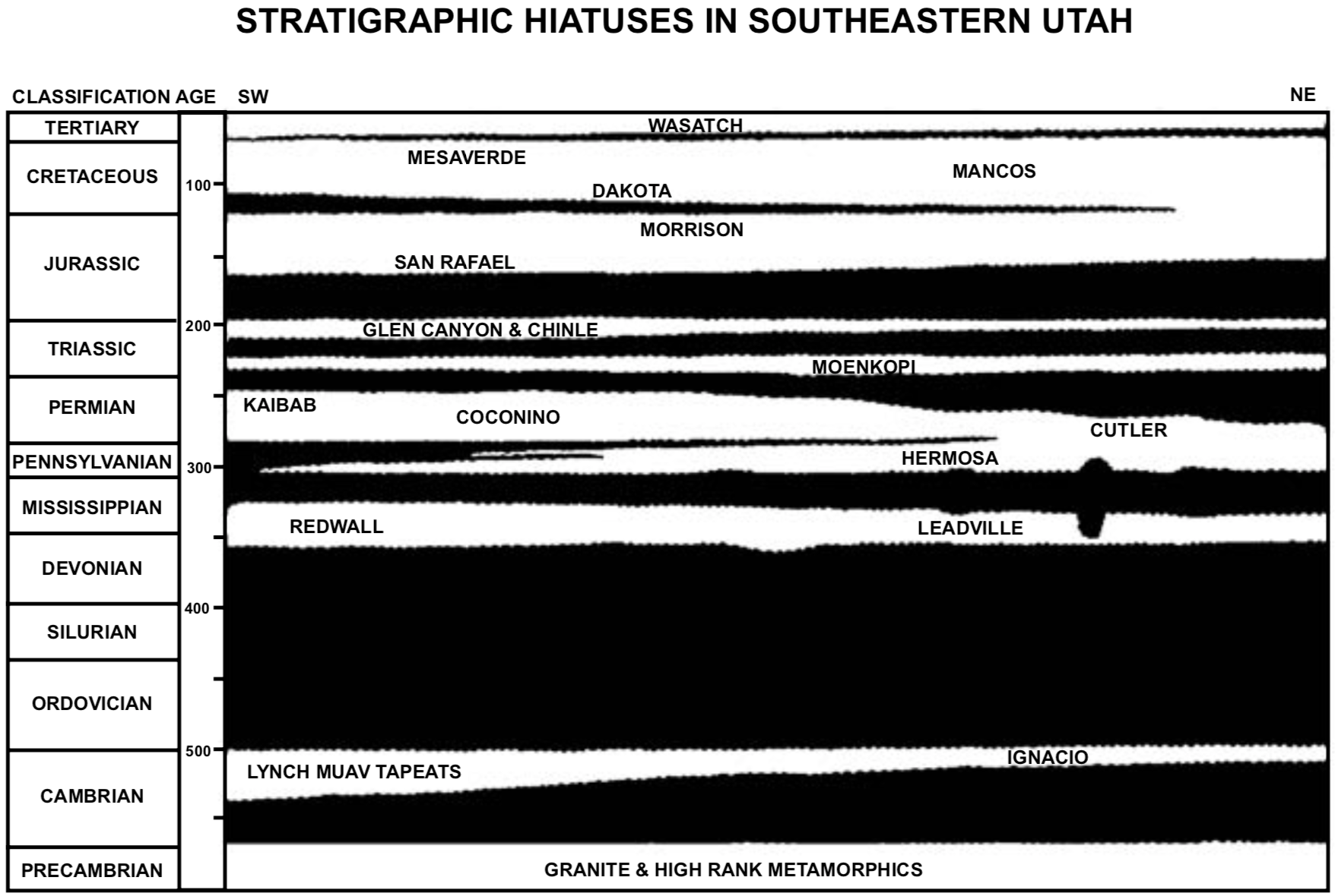
Missing divisions (gaps) of the standard geologic column are a common feature of the sedimentary layers of the earth. Figure 3 is an example, with the main missing portions represented in black. Charts for the Western United States (Molenaar 1973, p. 156; Molenaar 1978, p. 4; WGA 1980, inside front cover) suggest that about 1/3 or more of the major subdivisions (e.g., upper Triassic) are missing between various parts of the sequences. On a smaller scale much more is assumed to be missing. The "age" scale in Figure 3, which is in millions of years, gives an estimate of the time (black portions) between these layers. Surprisingly, the layers lie one on top of the other in orderly fashion without evidence of the extensive erosion expected during the purported time represented by the gaps. It should be noted that the vertical scale in this diagram is exaggerated approximately 16 times. We are dealing with relatively thin, widespread features.
FIGURE 3. Stratigraphic representation of the sedimentary layers in southeastern Utah. The clear areas represent sedimentary layers, while the black areas represent the main gaps (hiatuses). The main divisions of the geologic column are given in the left column, followed by their assumed age in millions of years. Names in the sedimentary portion represent only the major formations. Vertical exaggeration is about 16x. The horizontal distance represents about 200 km, while the total thickness of the layers (clear part) Is about 3½ km. Diagram modified from Molonaar (1975, p. 4) to emphasize a more linear time scale.
The question often arises as to how one determines the length of time involved at these gaps. It is based mainly on the absence of layers that are present elsewhere and have been dated with characteristic fossil types. It is assumed that much time is involved in the evolution of these characteristic fossils, as well as the deposition of the layers containing them. It is mainly by correlating and comparing with composite, complete sequences of the geologic column that conclusions are drawn concerning missing portions. Radiometric dating is also used, especially in establishing a broad time framework for the layers.
Geologists who have long been aware of these gaps usually designate them as "unconformities." In Great Britain the tendency is to frame the terminology on the basis of structural features, instead of assumed time; hence, the term "unconformity" has somewhat of a different meaning there.
There are several types of unconformities. If the layers above and below are at an angle to each other, the term angular unconformity is used; if they are generally parallel but with some evidence of erosion between the layers, the contact is sometimes called a disconformity; and if the contact is not visible or there is no evidence of erosion, it is called a paraconformity. We are especially interested in the latter two types, bearing in mind that terminology is not well-standardized. Related to these contacts is the term conformable, which is often used to designate the parallel union of different formations.
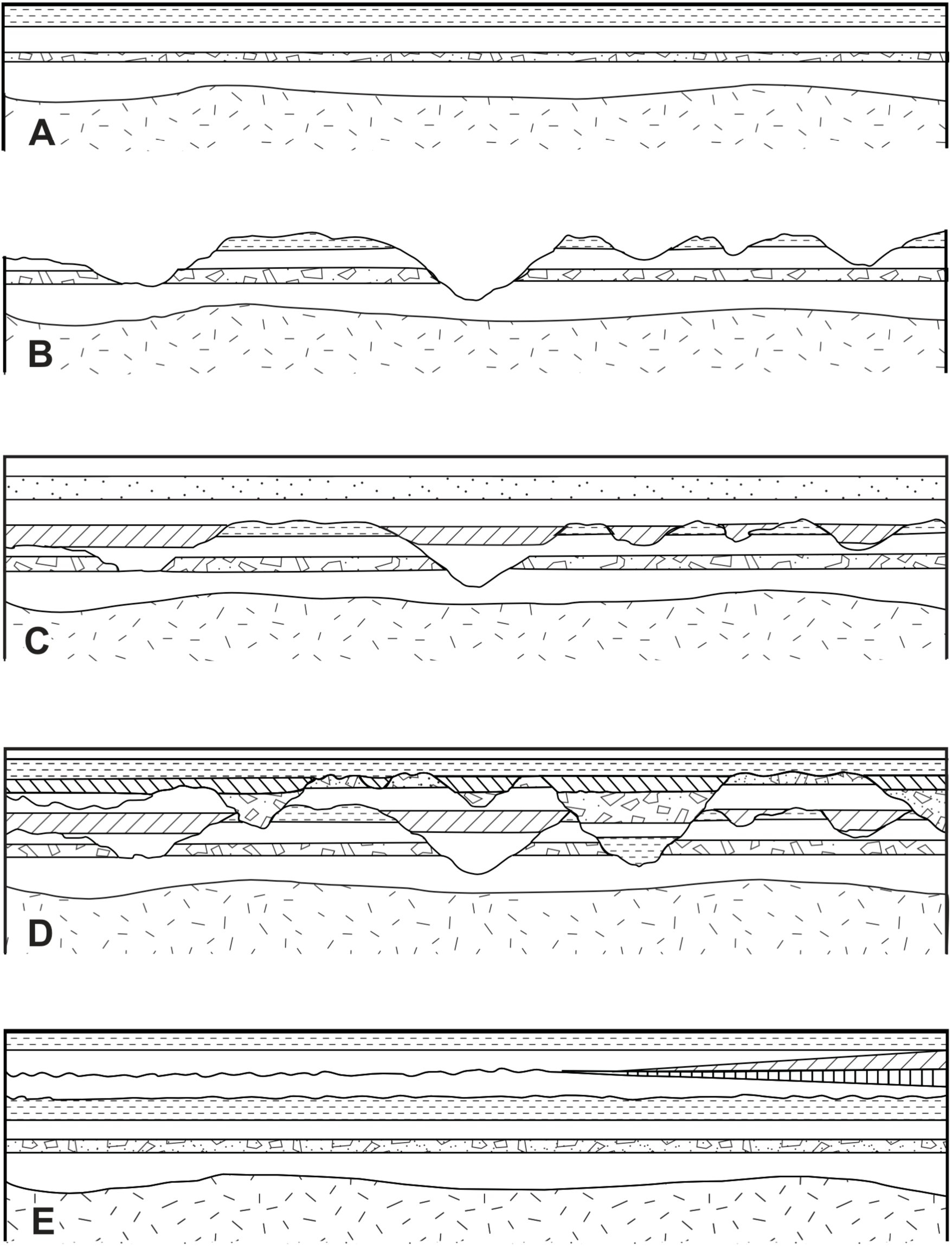
The question of erosion at these gaps is illustrated in Figure 4. The top diagram (A) illustrates a cross-section of the deposition of sedimentary layers with no appreciable time between the layers.
FIGURE 4. Erosion-deposition patterns. A: Pattern of continuous deposition. B: Erosion. C: Resumption of sedimentation. The old erosion surface is still visible. D: A second cycle of erosion and deposition further complicates the pattern. E: The more normal pattern seen. One would expect significant erosion between layers 2 and 3 from the top on the left side, if extensive time was involved in laying down layers 3 and 4 wedged in on the right. Hypothetical diagram with variable vertical exaggeration depending on erosional conditions.
The second diagram (B) illustrates what happens when there is no deposition and there is ample time for erosion. This creates the gullies, canyons and valleys common to the eroding surfaces of our world.
The third diagram (C) shows this irregular erosion pattern covered by subsequent layers. The topography left by past erosion is easily seen. This type of pattern should be common within the sedimentary layers of the earth where significant parts of the geologic column are missing; yet, only rarely do we see ancient valleys and canyons in the sedimentary layers of the continents.
The fourth diagram (D) illustrates the effect of a subsequent cycle of erosion, followed by deposition over the pattern in the third diagram. The pattern of distribution of layers would become more complex as more episodes of erosion and deposition are envisioned.
The fifth diagram (E) illustrates the more normal pattern that is seen (e.g., Figures 1-3), with little or no erosion between layers. If millions of years were involved between these layers, one would expect a significant amount of erosion, for instance, between the second and third layers from the top on the left side of Figure 4. This time period would be based on the millions of years assumed for the deposition of the third and fourth layers wedged in on the right side.
Numerous other examples of gaps (unconformities) could be given, e.g., Figure 3. Because of space limitations, just a few additional sites will be mentioned.
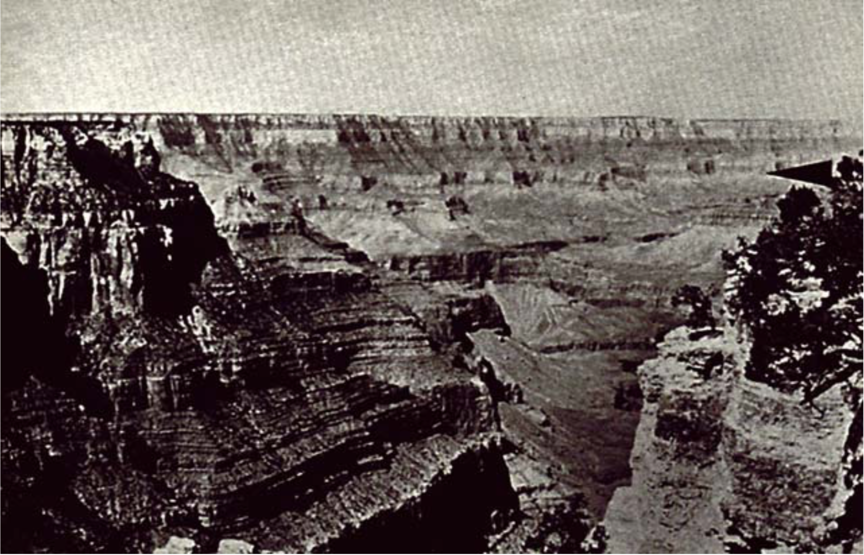
The Grand Canyon of the Colorado River is one of the geologic showcases of the earth. When one stands on its rim, one is impressed by many things, including how parallel the rock layers are; yet, significant time gaps are assumed between some of these layers. For instance, a little below the major middle cliff called the Redwall, about 100 Ma (Ordovician and Silurian) of deposition are missing (Figure 5 arrow). At the base of the Redwall itself, just slightly above the previous location, there is another assumed 6 Ma (Kinderhook) gap (Breed and Roat 1976, p. 54).
FIGURE 5. View of the Grand Canyon of the Colorado from the North Rim in Arizona. The arrow points to an assumed 100 Ma depositional gap in the layers.
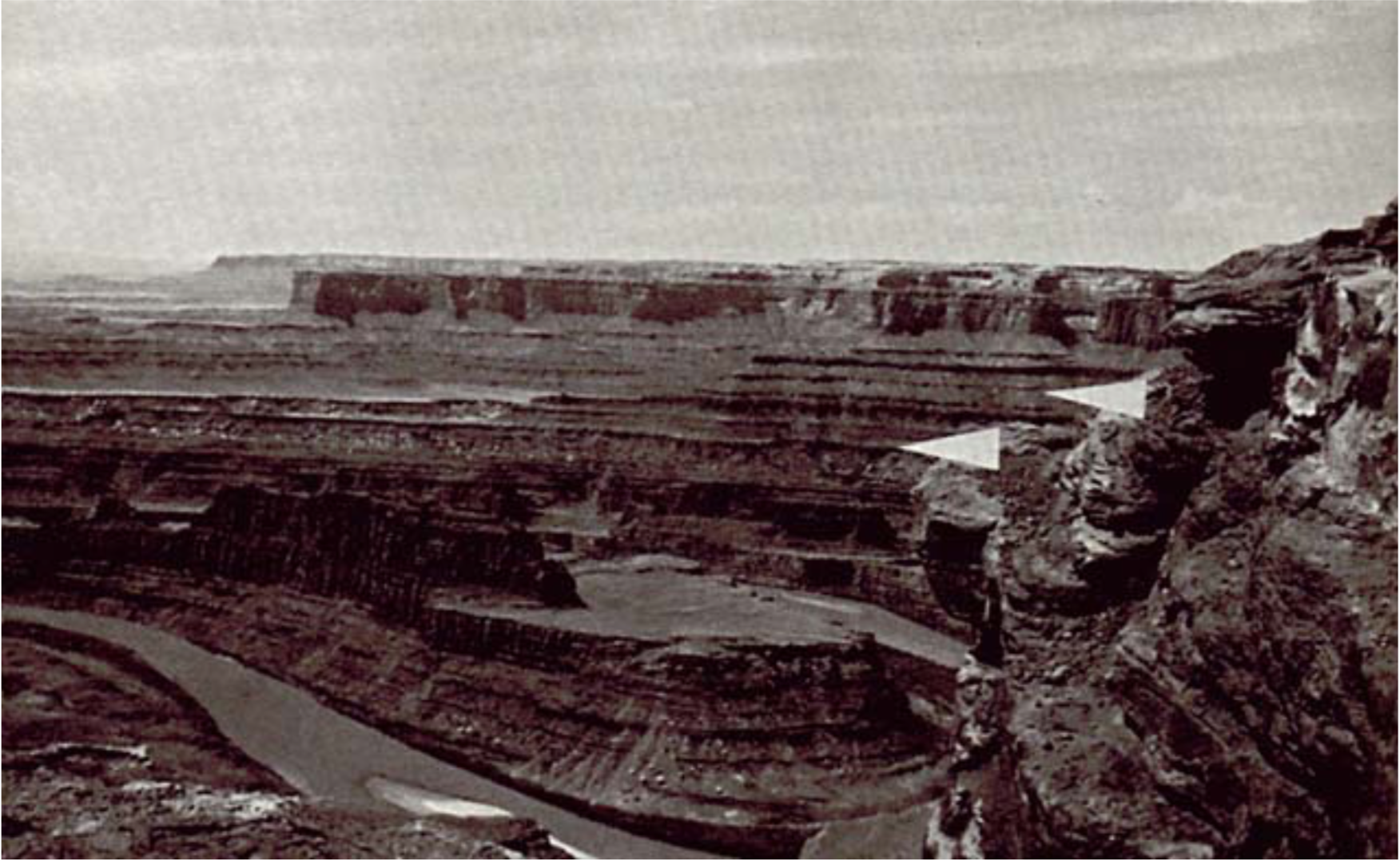
In eastern Utah one can view the dramatic erosion caused by the Colorado River at Dead Horse Point. The locality received its name because a number of wild horses died there before the turn of the century. The contrast between the effects of erosion forming the canyon and the parallel deposition of the layers is again striking (Figure 6). Within these layers are several assumed gaps. The lower arrow (right side) points to about 20 Ma (Ochoa-Guadalupe) assumed to be missing; the upper arrow (left side) points to about 10 Ma (Middle Triassic) of missing layers; yet, the contacts are very flat. This latter gap covers about 250,000 km2 in the southwestern United States and can be seen at many localities where present erosion has exposed it. These two gaps are also illustrated in Figure 3 and lie respectively just below and above the Moenkopi Formation in the Triassic.
FIGURE 6. Valley of the Colorado River from Dead Horse Point Utah. The top arrow points to an assumed 10 Ma depositional gap. The lower arrow points to a 20 Ma gap. Note the striking contrast between the flat depositional patterns of the layers at these 10 and 20 Ma hiatuses and the irregular erosion of the canyon by the Colorado River.
Along the east coast of Australia are excellent exposures of coal seams. At the top of the Bulli Coal (Figure 7 arrow) is another gap. The data given by Pogson (1972) suggest that the gap is about 5 Ma. Herbert and Helby (1980, p. 511) point out that this is a "basin-wide hiatus" with probably "world-wide significance." Geological mapping data (Pogson 1972) suggest that this hiatus covers some 90,000 km2. In the region where the Bulli Coal is present, it is especially difficult to envision this coal seam remaining for 5 Ma without being destroyed many times in that extended period of non-deposition.
FIGURE 7. East coast of Australia in New South Wales. The arrow points to an assumed 5 Ma gap above the coal layer.
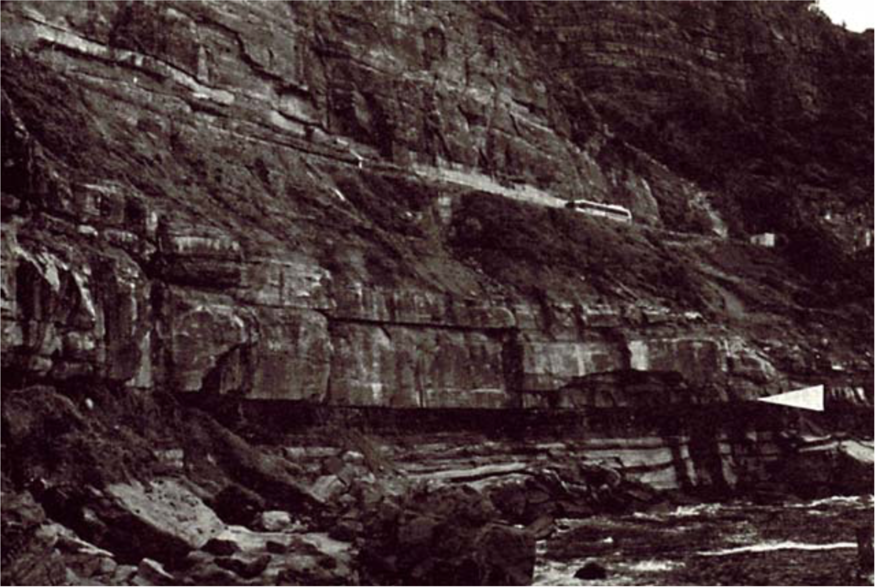
The European Alps are in part a complex of gigantic thrusted and folded units called nappes. Between the layers within these nappes are assumed gaps that show the same lack of erosion noted elsewhere. Figure 8 shows part of the Morcles Nappe as seen from the Rhône valley in Switzerland. The arrow points to an assumed gap of 35 Ma or more (Upper Cretaceous). Incidentally, the whole sequence of layers in the region below the arrow and all above it is overturned, having been folded (rolled) over as a unit as the layers were thrust laterally during the early stages of the formation of the Alps.
FIGURE 8. Valley of the Rhône in Switzerland. The arrow points to an assumed 35 Ma or more gap in sedimentation.
Some geologists have commented on the lack of evidence for changes expected at these gaps. In referring to the kind of gaps called paraconformities, Norman Newell (1967) comments:
A remarkable aspect of paraconformities in limestone sequences is general lack of evidence of leaching of the undersurface. Residual sods and karst surfaces that might be expected to result from long subaerial exposure are lacking or unrecognized.
While "speculating" on their origin, the author states further that:
The origin of paraconformities is uncertain, and I certainly do not have a simple solution to this problem.
Newell (1984, p. 125) also states:
A puzzling characteristic of the erathem boundaries and of many other major biostratigraphic boundaries [boundaries between differing fossil assemblages] is the general lack of physical evidence of subaerial exposure. Traces of deep leaching, scour, channeling, and residual gravels tend to be lacking, even where the underlying rocks are cherty limestones (Newell, 1967b). These boundaries are paraconformities that are usually identifiable only by paleontological [fossil] evidence.
T. H. Van Andel (1981) states:
I was much influenced early in my career by the recognition that two thin coal seams in Venezuela, separated by a foot of grey clay and deposited in a coastal swamp, were respectively of Lower Palaeocene and Upper Eocene age. The outcrops were excellent but even the closest inspection failed to turn up the precise position of that 15 Myr gap.
An additional point of interest related to this question is the fact that present rates of erosion on the earth are so rapid that many of the layers between the gaps should have been eroded away many times during the assumed long time period represented by the missing layers. Present rates of erosion for the United States average about 6.1 cm/1000 yrs (Judson and Ritter 1964), which is 61 m/Ma. In 10 Ma one would expect 600 m of erosion, etc. It is sometimes stated that our present rates of erosion should level the United States in 10 Ma or less.
It is well recognized that present rates of erosion cannot be easily reconciled with long geologic ages. In referring to some current rates of erosion, Sparks (1986, p. 510) emphasizes the problem:
Some of these rates are obviously staggering; the Yellow River could peneplain [flatten out] an area with the average height that of Everest in 10 million years.
Hence, if one assumes long geological ages, this not only raises questions about the lack of evidence for time at the gaps, but also questions about the presence of sedimentary layers between the gaps. Our present average rates of erosion could have long ago eroded many times the sedimentary record found on the continents. Sparks (1986) states further:
The student has two courses open to him: to accept long extrapolations of short-term denudation [erosion] figures and doubt the reality of the erosion surfaces, or to accept the erosion surfaces and be skeptical about the validity of long extrapolations of present erosion rates.
I would suggest a third course which could reconcile the dilemma; namely, to accept present rates of erosion in the context of a short period of time for the Phanerozoic record in which one would not need to try to resolve the paradox of long-term effects. The implications of these effects as they relate to catastrophism has been discussed elsewhere (Roth 1986).
In summarizing this section, it can be stated that assumed gaps in the sedimentary layers of the earth are common. The physical evidence for the assumed time of millions of years is missing. Under normal conditions, we expect either erosion or deposition. Surfaces at paraconformities and disconformities seem to show little of either.
One must keep in mind that evidence of time missing in one locality suggests the absence of that time over the entire globe. The lack of evidence for time can be reconciled by a model in which sedimentary layers were laid down rapidly by events associated with the catastrophic flood described in Genesis. This idea is buttressed by the fact that current rates of erosion suggest that over the long assumed ages the layers between the gaps should also be eroded away.
SOME QUESTIONS
We shall now address several questions that can be raised about the suggestion given above.
1. Are there not very flat areas on the surface of the earth that could represent these gaps? Our earth has very flat areas, the flattest being the lake bottoms and abyssal plains on the floor of the oceans. However, there are regions where sediment is being laid down in a flat pattern and do not represent gaps in deposition. They must not be confused at all with regions where sedimentation is not occurring and erosion is taking place. Gaps would be expected at these latter regions. Sediment is usually laid down in a near-horizontal pattern, and there are many broad, flat regions, such as the lower Mississippi Valley of the United States, or the Canterbury plains of New Zealand, where sediment is being deposited in a broad, flat pattern. Areas in which sediment deposition is not occurring are typically very irregular because they are subject to erosion. The usually flat contacts at the assumed gaps do not show the degree of irregularity normal to erosional regions. They also do not show deposition; if they did, there would be no assumed gap.
2. Can there be flat areas of the earth where neither deposition nor erosion are taking place? There may be one or more such areas, but they are the exception and could not account for the abundance of these flat gaps throughout the sedimentary layers of the earth. Some geomorphologists have appealed to the presently arid central Australia as an area where deposition and erosion are very slow. This is an exception that does not represent normal conditions of erosion and deposition on the earth. The fossil evidence found in the layers associated with almost all the gaps does not represent a climate similar to arid central Australia. For instance, the horses and mastodons of the Ogallala demand significant precipitation to produce the vegetation necessary for their survival. In the long time envisioned at these gaps, we would expect much erosion or much deposition under any nearly normal climatic circumstances. There are a few exposed areas of earth that are assumed to be older surfaces that do not show much of the effects of erosion. Their significance depends on their assumed age. The Llano Estacado mentioned earlier is one of them; however, it is considered to be only a couple of million years old. More significant are such areas as Kangaroo Island and the surrounding Gulfs region in South Australia. Kangaroo Island, which is about 140 by 60 km, has a surface assumed to be 200 Ma old (Daily, Twidale and Milnes 1974). When I visited it, I was impressed by the extreme flatness of most of the island. Figure 9 shows only a small region of this island. Could such a flat surface exist without deposition or erosion for 200 Ma? Ice ages and other climatic factors should have had dramatic effects. Twidale (1976), in assuming long ages, outlines the problem:
Even if it is accepted that estimates of the contemporary rate of degradation of land surfaces are several orders too high (Dole and Stabler, 1909; Judson and Ritter, 1964; see also Gilluly, 1955; Menard, 1961) to provide an accurate yardstick of erosion in the geological past there has surely been ample time for the very ancient features preserved in the present landscape to have been eradicated several times over. Yet the silcreted land surface of central Australia has survived perhaps 20 m.y. of weathering and erosion under varied climatic conditions, as has the laterite surface of the northern areas of the continent. The laterite surface of the Gulfs region of South Australia is even more remarkable, for it has persisted through some 200 m.y. of epigene [surface] attack. The forms preserved on the granite residuals of Eyre Peninsula have likewise withstood long periods of exposure and yet remain recognizably the landforms that developed under weathering attack many millions of years ago.
FIGURE 9. View of part of Kangaroo Island, South Australia. Across the bay the general flatness of this island can be seen. The surface of this island is assumed to be some 200 Ma old.
Twidale states further:
The survival of these paleoforms [as Kangaroo Island] is in some degree an embarrassment to all of the commonly accepted models of landscape development.
Survival of the flat surface of Kangaroo Island is not an embarrassment if one does not assume the long ages proposed. Twidale (1976) proposes some solutions to the problem, but one is faced with trying to resolve the dilemma that with a conservative erosion rate of 3 cm/1000 yrs, Kangaroo Island should have been eroded down 6 km in 200 Ma. One would have to postulate very odd conditions to explain the survival of the surface of Kangaroo Island for 200 Ma. Extreme conditions can be postulated, but one should be cautious about deriving too many generalizations from the abnormal. It is implausible to assume that neither deposition nor erosion would occur over the millions of years envisioned. Normal erosion rates seem to preclude arguing that present flat surfaces, assumed to be old, represent examples of no erosion.
3. Is it not possible to have flat erosion? We generally think of erosion as accentuating topographic irregularities with time. The longer erosion continues, the deeper our gullies, canyons and valleys become. Twidale, Bourne and Smith (1974) and Twidale (1976) have proposed a landscape model that incorporates this factor. As long as gravity keeps pulling water downward, this kind of activity is to be expected.
On the other hand, to explain the flat gaps we have been considering, some models have proposed lateral erosion down to planar surfaces. The most famous is the peneplain concept proposed about a century ago by the well-known Harvard geomorphologist W. M. Davis. He postulated eventual flat erosion under special conditions, forming a peneplain (almost a plane). His model, which gained considerable acceptance in the early part of this century, is no longer accepted. Garner (1974, p. 12) states: "The peneplain is Davis's 'old age' landscape. It has been called an imaginary landform. Perhaps it is." One would expect that any process forming the abundant, widespread, flat gap contacts in the geologic record of the past would be well-represented on the present surface of the earth; yet, Bloom (1969, p. 98) states that "unfortunately, none are known" and Pitty (1982, p. 77) points out that "although demonstrable unconformities abound, even W. M. Davis admitted that it was difficult to point to a clear present-day example of a peneplain."
No other generally accepted concept has replaced the peneplain model, although there have been considerable discussions and disputations about laterally directed slope erosion leaving flat surfaces. L. C. King (1950) in South Africa proposed pediplanation, a process that involves both erosion and deposition. These models do little to explain the subsequent erosion expected over long time periods when deposition stops and the time for the gap begins.
One can also ask if flat erosion would occur over a hard surface, such as a tough limestone layer. While limestone appears to degrade about as rapidly as other rocks (see Sparks 1986, p. 511), it does at times form resistant layers compared to softer layers such as shale. This will not resolve the problem of flat erosion, since many of the gaps that we are discussing are over softer formations with abundant shale. The Ogallala Formation in Texas and New Mexico mentioned above lies on softer sediment assumed to be 200 Ma older. The Shinarump in the southwestern U.S. lies on the softer Moenkopi assumed to be 10 Ma older. It is difficult to conceive of these relatively soft layers spread over hundreds of thousands of km2 for these long periods not being eroded away. This raises another question.
4. Could these time gaps have been protected in the past by resistant or thick layers lying over them? This postulation raises the question of why erosion should proceed through a hard or thick protective layer and stop at the softer units mentioned above. These units are relatively thin, widespread and well-preserved. Rapid deposition without the long assumed time between may be a more satisfactory explanation for the data.
5. Isn't there evidence of erosion at these time gaps? It is not surprising that in numerous instances there is evidence of some minor erosion at these gaps. Erosion would occur as water or wind would transport the sediments for the layers above the gaps. Rarely, at these planar surfaces, there is some evidence of deeper erosion, sometimes even several hundred meters of erosion. However, the general pattern shows little erosion, and the contacts are remarkably flat (Figures 1-3, 4-8). Moreover, the presence of erosion is not an argument against rapid action. Erosion can occur very rapidly under catastrophic flood conditions.
6. If the layers at the top of the gaps were underwater, would this not preclude their being eroded? Erosion and deposition proceed under water as well as above. Presently there are no special, widespread, underwater environments where neither deposition nor erosion are occurring. Some of the formations below these gaps, such as the Trujillo and Chinle mentioned above, do not contain the kind of fossils expected in an underwater environment.
CONCLUSIONS
The assumed gaps in the sedimentary layers are not readily noticed, because the layers above and below are in intimate contact with each other and are usually parallel or nearly parallel. Nevertheless, these gaps are abundant. Bloom (1969, p. 98) states:
The geologic record of sedimentary rocks is full of unconformities that represent long periods of emergence and erosion of continent-sized regions. These unconformities are commonly nearly planar....
This flat and parallel, or near-parallel, arrangement at these gaps seems to be different from the eroding surfaces of much of our present earth.
The difficulty with the extended time proposed for these gaps is that one cannot have deposition, nor can one have much erosion. With deposition, there is no gap, because sedimentation continues. With erosion, one would expect abundant channeling and the formation of deep gullies, canyons and valleys; yet, the contacts are usually "nearly planar." Over the long periods of time envisioned for these processes, erosion would erode the underlying layers and much more. One has difficulty envisioning little or nothing at all happening for millions of years on the surface of our planet. The gaps seem to suggest less time.
Our current topography does not represent an extension from the ancient past. Ashley's (1931) provocative study points out how recent our present topography is and argues that 99% of it was formed in an assumed 15 Ma, which would be very recent on an earth assumed to be thousands of millions of years old. Thornbury (1969, p. 25) states that little of earth's topography is older than Tertiary (67 Ma ago), and most of it is no older than Pleistocene (2 Ma ago).
This raises the question of what happened to the topography for the assumed hundreds of millions of years before that. Our present topography is so dramatic in places that it is difficult to think of ancient topography being so poorly represented. Yet, our Everests and Grand Canyons seem conspicuously absent in the record of the past, while that past is still very well-represented in the older sedimentary layers of the earth. Dramatic topography should be especially noticeable at the assumed long time periods (gaps) between the layers, when there would be ample time for uplift and erosion.
It is often difficult to discern what happened in the past; however, the assumed gaps in the sedimentary layers witness to a past that was very different from the present. In many ways, that difference is readily reconciled with catastrophic models such as the Genesis flood that proposes the relatively rapid deposition of these layers.
REFERENCES
Ashley, G. H. 1931. Our youthful scenery. Geological Society of America Bulletin 42:537-546.
Bloom, A. L. 1969. The surface of the earth. Prentice-Hall, Inc., Englewood Cliffs, New Jersey.
Breed, W. J. and E. Roat (eds.). 1976. Geology of the Grand Canyon. 2nd ed. Museum of Northern Arizona, Flagstaff, and the Grand Canyon Natural History Association, Grand Canyon, Arizona.
Daily, B., C. R. Twidale and A. R. Milnes. 1974. The age of the lateritized summit surface on Kangaroo Island and adjacent areas of South Australia. Journal of the Geological Society of Australia 21(4):387-392.
Garner, H. F. 1974. The origin of landscapes. Oxford University Press, New York.
Herbert, C. and R. Helby (eds.). 1980. A guide to the Sydney Basin. Department of Mineral Resources, Geological Survey of New South Wales Bulletin 26.
Judson, S. and D. F. Ritter. 1964. Rates of regional denudation on the United States. Journal of Geophysical Research 69:3395-3401.
King, L. C. 1950. The study of the world's plainlands: a new approach in geomorphology. The Quarterly Journal of the Geological Society of London 106:101-131.
Matthews, W. H., III. 1969. The geologic story of Palo Duro Canyon. Guidebook 8, Bureau of Economic Geology, The University of Texas at Austin.
Maxwell, R. A. 1970. Geologic and historic guide to the state parks of Texas. Guidebook 10, Bureau of Economic Geology, The University of Texas at Austin.
Molenaar, C. M. 1973. Nomenclature chart of the Canyonlands and adjacent areas. In H. L. James (ed.). Guidebook of Monument Valley and vicinity, Arizona and Utah, p. 156. New Mexico Geological Society Twenty-fourth Field Conference.
Molenaar, C. M. 1978. Correlation chart. In J. E. Fassett (ed.). Canyonlands country, p. 4. A Guidebook of the Four Corners Geological Society Eighth Field Conference.
Newell, N. D. 1967. Paraconformities. In C. Teichert and E. L. Yochelson (eds.). Essays in Paleontology and Stratigraphy, pp. 349-367. Department of Geology, University of Kansas Special Publication 2.
Newell, N. D. 1984. Mass extinction: unique or recurrent causes? In W. A. Berggren and J. A. Van Couvering (eds.). Catastrophes and Earth History: The New Uniformitarianism, pp. 115-127. Princeton University Press, Princeton, New Jersey.
Pitty, A. F. 1982. The nature of geomorphology. Methuen & Co., London and New York.
Pogson, D. J. 1972. Geological map of New South Wales. 1:1000,000. Geological Survey of New South Wales, Sydney.
Roth, A. A. 1986. Some questions about geochronology. Origins 13:64-85.
Sparks, B. W. 1986. Geomorphology. 3rd ed. Longman Group, London and New York.
Thornbury, W. D. 1969. Principles of geomorphology. 2nd ed. John Wiley & Sons, Inc., New York.
Twidale, C. R. 1976. On the survival of paleoforms. American Journal of Science 276:77-95.
Twidale, C. R., J. A. Bourne and D. M. Smith. 1974. Reinforcement and stabilisation mechanisms in landform development. Revue de Geomorphologie Dynamique 23(3):115-125.
Van Andel, T. H. 1981. Consider the incompleteness of the geological record. Nature 294:397-398.
WTSU. n.d. Guidebook of Palo Duro Canyon. West Texas State University Geological Society.
WGA. 1980. Stratigraphy of Wyoming. 31st Annual Field Conference Guidebook. Wyoming Geological Association.
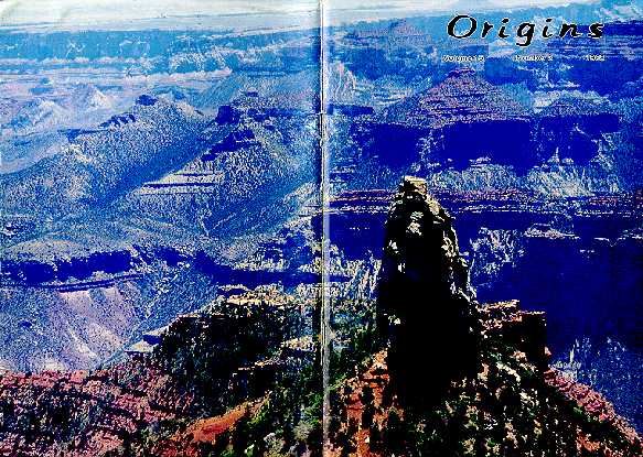
COVER. One of the many buttes left by erosion in the Grand Canyon of the Colorado River in Arizona. The view is to the southeast from Point Imperial on the North Rim of the Canyon. Notice the contrast between the irregular erosion seen here and the flat layers forming the rocks of the Canyon in the background.