THE GRAND STAIRCASE: A CASE STUDY IN SCIENTIFIC THINKING FROM A BIBLICAL WORLDVIEW
by
Leonard Brand Professor of Biology and Paleontology Loma Linda University
ABSTRACT
In Utah and northern Arizona is a unique geological landscape feature, called the Grand Staircase. Imagine a staircase with each step a thousand feet or more high, and many miles wide. That is the Grand Staircase. Each step is a cliff composed of one or more geological formations. The group of formations forming each step begins in Utah and continues to the south until it ends in a cliff. The oldest rocks in this sequence, the Paleozoic rocks seen in the walls of the Grand Canyon, form the lowest step. Each higher step has younger rocks, and its cliff is farther north. The youngest rocks, those forming the highest cliff, don’t extend farther south than the northern part of Utah. How was this staircase formed? A river erodes the land into a valley. The river valley may be deep and narrow, or it may form a wide flood plain, but a river always has a riverbank on each side. The Grand Staircase is like a valley with a riverbank (the series of cliffs) on only one side. There is much evidence that the Grand Staircase must have been carved out of the landscape, not be rivers, but by a massive, catastrophic flow of water across southwestern United States.
THE TASK
Previous publications have discussed the concept that a biblical worldview can be applied in ways that suggest scientifically testable hypotheses, and thus lead to productive research.[1] The source of these ideas may come from outside of conventional science, but the ideas and hypotheses can be fully testable by standard scientific research procedures, as exemplified by a number of research projects cited in these references.[1] The following is an example – a case study of what it means to apply that method in geological research.
One of the first principles to recognize is that science does not often prove things, and this applies with double force in study of ancient history. Bible believers are often tempted to want proof of creation or the flood. Science does not offer that proof (or disproof). Valid application of science involves defining hypotheses, and then seeking to test them; to see if these ideas are useful in interpreting the evidence. Of the hypotheses that have been proposed, we want to know which seems to best explain the available evidence.
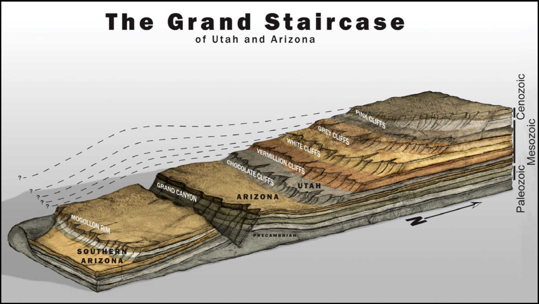
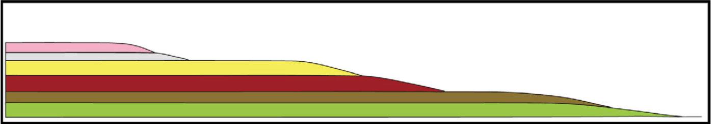
Figure 1. A diagrammatic drawing of the Grand Staircase. Artwork by Doug Oliver.
In southern Utah and northern Arizona is a magnificent landscape feature called the Grand Staircase (Fig. 1) and we will discuss hypotheses in regard to how this feature was formed. The staircase is a series of giant steps, actually cliffs, dropping down across southern Utah, all the way to the Grand Canyon. At each step a portion of the rock layers forming the geological column ends in a generally southward-facing cliff. The question we will address is what geological processes formed this series of steps? Why do each of these groups of rock formations suddenly end in a cliff?
For those who are not geologists we will review several geological processes pertinent to study of the Grand Staircase. Readers who already know the basic geology may wish to skip down to the heading “Methods of Study of the Grand Staircase.”
Each rock formation was formed when sediment, such as sand, mud, or pebbles was carried, usually by water, and deposited in a sedimentary layer, or calcium carbonate was precipitated to form limestone. A “formation” is a discrete unit of rock with identifiable characteristics that can be traced and mapped over a recognizable geographic region. Some formations are uniform in composition, e.g., sandstone (all or primarily sand), or mudstone (fine sediment like silt or clay), but more often they are a combination of more than one type of sediment. These are deposited one formation above the other, with each formation accumulating through some unit of time. The entire set of formations forms the layer cake structure called the geological column (labeled at right side of Fig. 1). A representative sample of the geological column can be seen in Utah and Arizona.
The Grand Canyon was carved through Precambrian and Paleozoic rocks. Those Paleozoic formations extend to the north, under the several formations in southern Utah forming the Triassic portion of the regional sequence of layers (Moenkopi, Chinle, including its basal member the Shinarump Conglomerate, and the Moenave are prominent Triassic formations). These Paleozoic and Triassic formations, or equivalent formations, extend to the north under the Jurassic and Cretaceous formations. Together, the Triassic, Jurassic and Cretaceous form what is known as the Mesozoic part of the sequence of layers. Farther north there are Cenozoic formations on top of the Paleozoic and Mesozoic rock formations. This entire series of formations composes a time-sequence, like a history book; the lower layers are the oldest, and the upper layers are sequentially younger. This chronological sequence is real, whether one believes it formed in a few thousand years, or in hundreds of millions of years.
After these formations were deposited, they were at some time eroded to form the landscape we now see. The features of our landscape always have a geological reason for their characteristics.[2] For example, sandstones and limestones are quite resistant to erosion, and typically erode into cliffs, while softer rocks like mudstone or shale erode into softer hills, slopes and valleys. This landscape-shaping erosion occurs largely through the energy of flowing water, such as streams, rivers, ocean waves, or ocean currents.
Ocean waves cut their way through the rock along the shore, moving the shoreline back, and sometimes taking our prime shorefront real estate with them. Rivers carve channels, with a river bank on each side of the channel.
Notice that a river leaves a bank, or cliff, on each side of the river channel. We seldom see truly catastrophic water erosion, but experiments and a few geological features indicate the unimaginable power of water moving rapidly on a large scale. As water erodes the landscape it may carve cliffs, with a more erosion-resistant layer forming the cliff, or at least the top of the cliff.
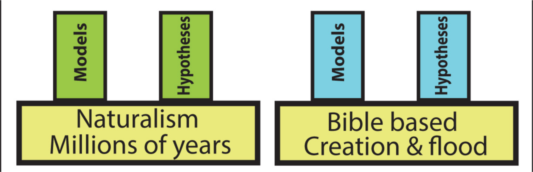
In conventional geological theory the major share of erosion through geological history occurred by processes we can observe on the earth today, whereas a biblical worldview implies that some significant portion of erosion events included erosion on a catastrophic scale far beyond our experience. Conventional scientists use their naturalistic paradigm as a basis for developing hypotheses, and a biblical worldview can be used the same way (Fig. 2). With these concepts in mind, let us return to the Grand Staircase.
Figure 2. Two approaches to research, each basing its models and hypotheses on a worldview that undergirds the thinking of the researcher. In each case the underlying worldview is pictured as the foundation, and models and hypotheses are built on the principles of that worldview.
METHODS OF STUDY OF THE GRAND STAIRCASE
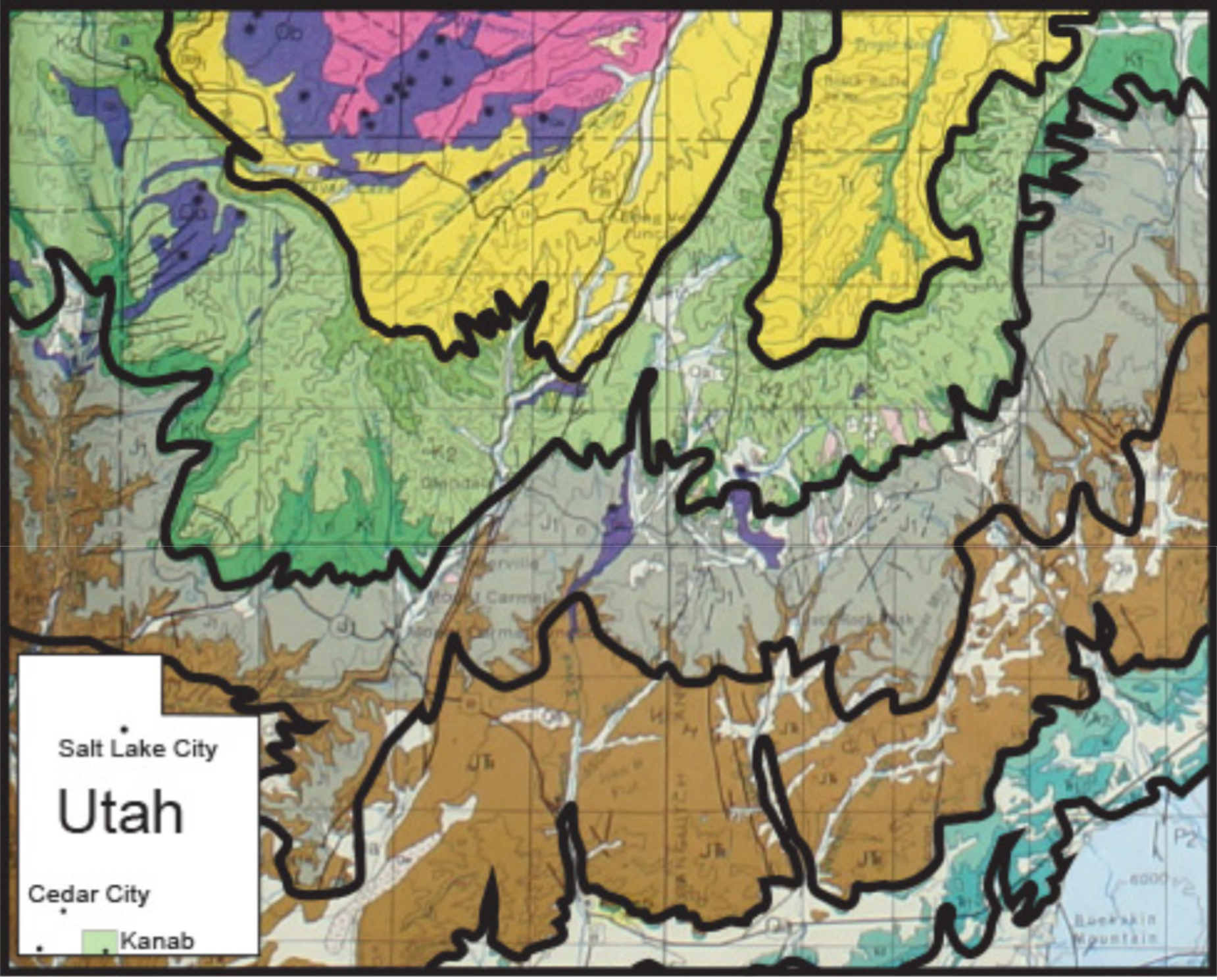
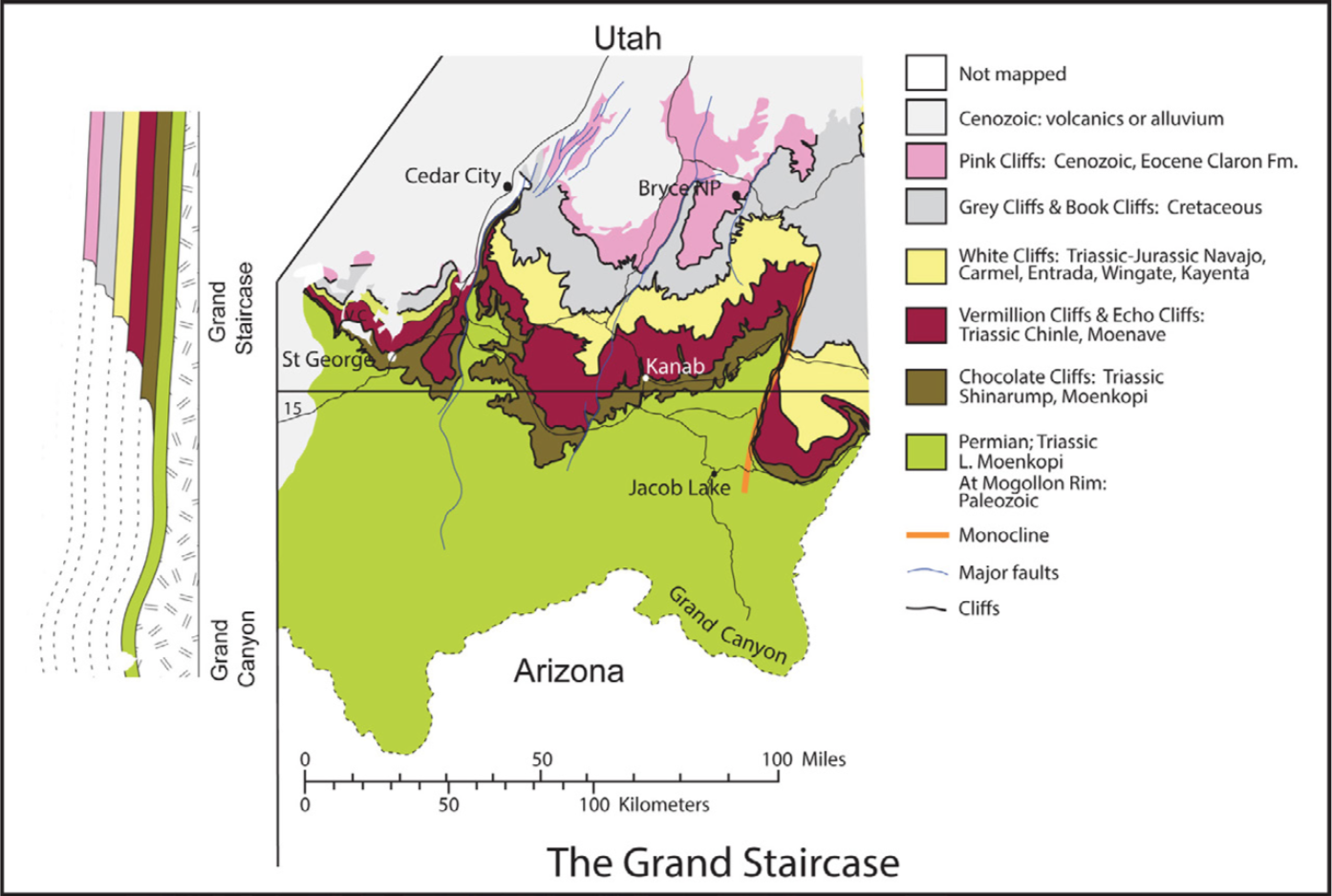
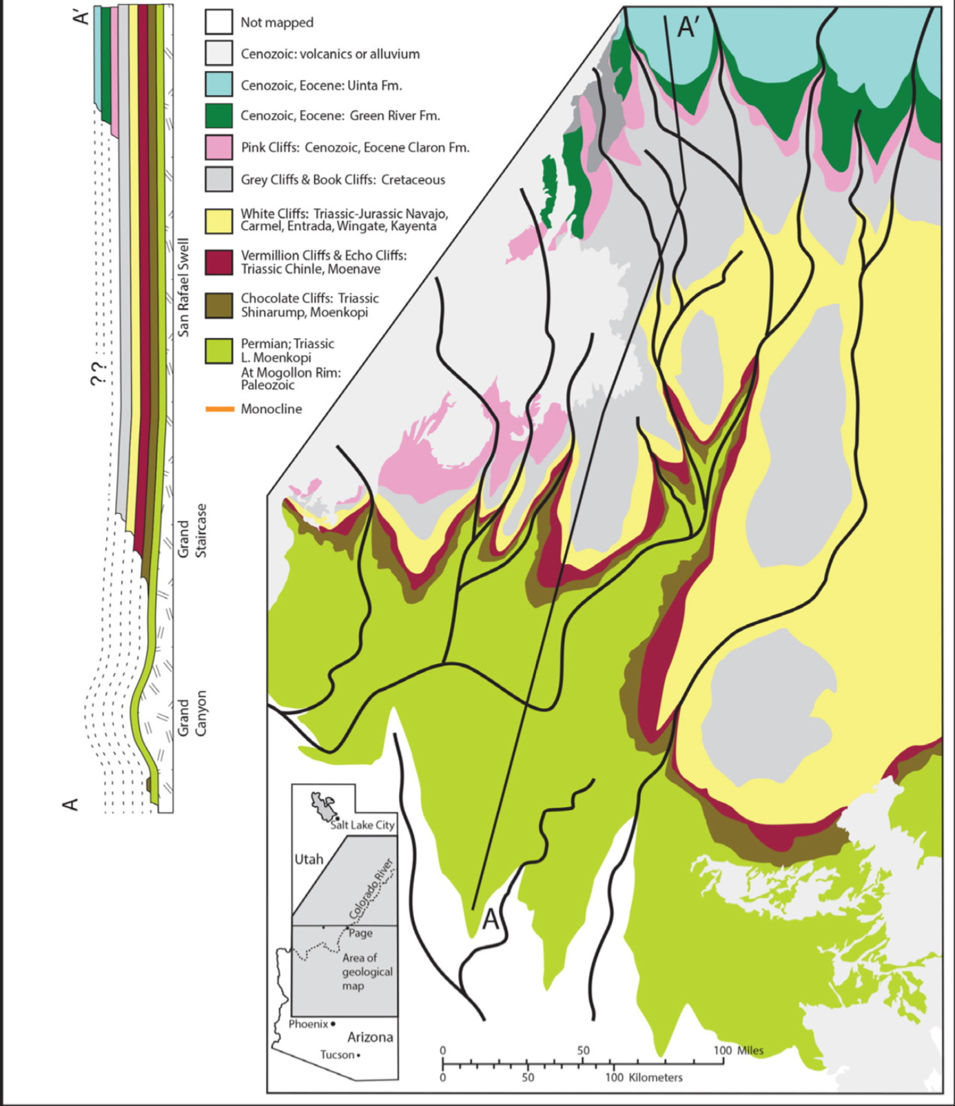
The first step in this project was to find what is known of the geology of the Grand Staircase. Geological maps provided basic information on the rock formations involved, and the nature of their exposure across the Staircase. Other literature on these formations was studied and much travel through Arizona and Utah over several decades provided personal acquaintance with the geology of the region. With this background in mind, the next step was to photograph the geological maps of Utah and Arizona and enter these photographs into Adobe Illustrator.[3] Then color overlays were made, forming bands of color corresponding to the distribution of specific rock formation outcrops across the landscape. Each color band shows the distribution of the set of rock formations composing one of the steps in the Grand Staircase (Fig. 3).
Figure 3. A portion of the geological map of Utah. Each solid line traces one of the cliffs of the Grand Staircase. Color bands show the plateaus above these cliffs. Inset: map of Utah showing location of this map (green rectangle).
THE GRAND STAIRCASE
The lowest step includes primarily the Paleozoic in the walls of the Grand Canyon, with the Kaibab Limestone forming the top of the cliff.
The next step is called the Chocolate Cliffs (or Shinarump Cliffs). The top of this cliff is formed by the erosion-resistant Shinarump Conglomerate. Above that, several red Triassic formations make up the Vermillion Cliffs. The next cliff, the White Cliffs is formed by the Triassic/Jurassic Navajo Sandstone (as in the walls of Zion Canyon). The Navajo Sandstone in this cliff is primarily white, but in other places it is red, forming part of what is locally called the red-rock country in Utah. The Grey Cliffs are Cretaceous grey shales and other relatively soft rocks. Consequently the Grey Cliffs are not as sharply defined as the other cliffs. Above the Cretaceous Grey Cliffs comes the Cenozoic Claron Formation in the Pink Cliffs.
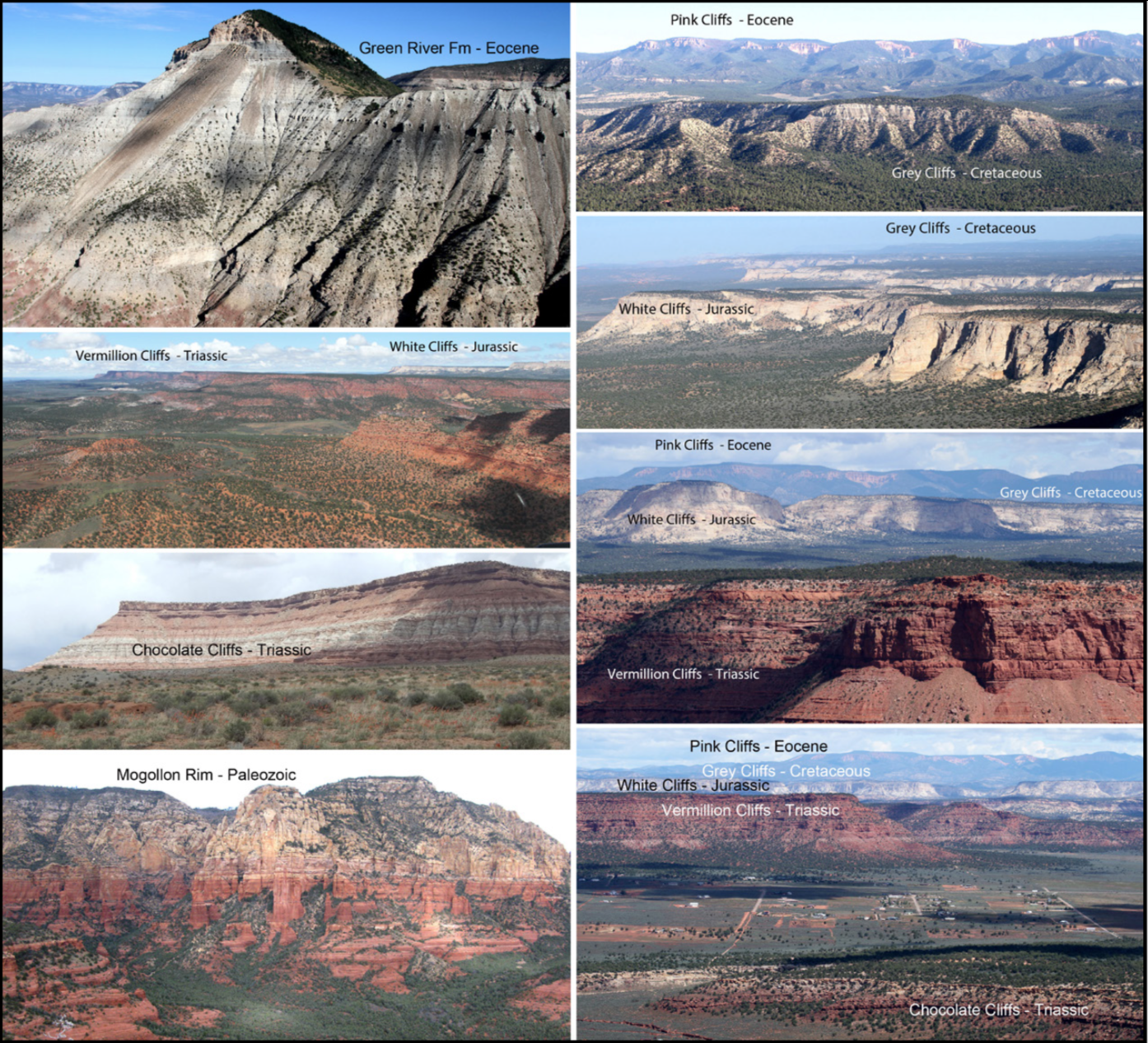
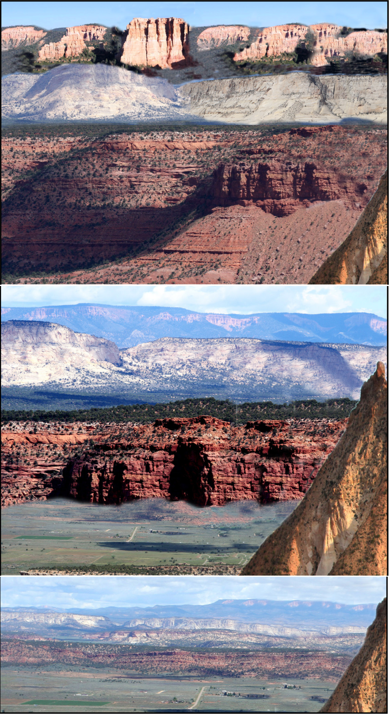
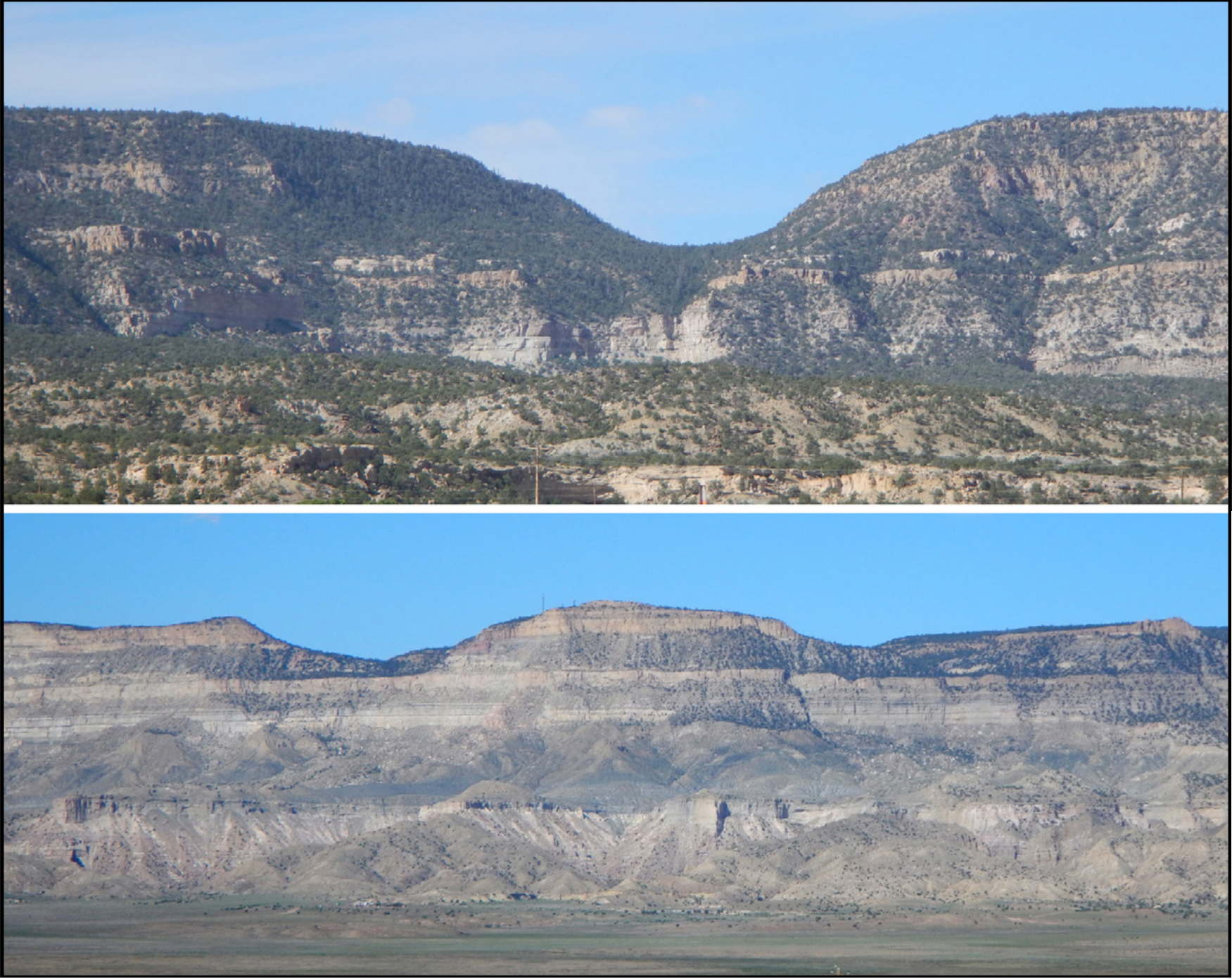
The sequence of cliffs shown in Figure 1 is a very real series of giant steps, with a broad, flat plateau at the top of each step. These are shown in the photographs in Figure 4. The question we are pursuing is how did this staircase form? What type of water action would be expected to carve such a series of steps?
Figure 4. Photographs of the Grand Staircase cliffs, looking approximately to the north or west. The order of the cliffs is as listed in the caption for Figure 1.
HOW DID THE STAIRCASE FORM?
Our first question is whether the steps are primarily the result of erosion of formerly widespread deposits as usually interpreted, or whether these rock formations were originally deposited only where they now appear, with each set of formations only deposited part way south through Utah. If the latter was the case it could explain why the formations did not go farther south, but ended at different places along the way. If they were deposited that way we would expect the formations to get thinner toward the south, until they pinch out, as in Figure 5.
Figure 5. A cross-section through the same series of rock formations as in Figures 1, 3 and 4, but pictured as they might appear if each formation was deposited to the north and became thinner toward the south, andpinched out (the deposit originally ended) approximately where itcurrently ends. This contrasts with the concept that each formation originally was deposited far to the south as indicated by the dotted linesin Figure 1, and then was eroded back to its end in a cliff, which is theaccepted interpretation.
But they are not like that. Some formations get a little thinner, but others get thicker toward the south. The overall effect is not a thinning toward the south, as would be expected if they were not deposited farther south.[4] Each group of formations just continues until they end in a cliff as in Figures 1 and 4. South of each cliff face they were eroded away. The evidence indicates they must have continued much farther south before they were eroded back to where the cliff now is. The dotted lines in Figure 1 indicate how these formations are believed to have been continuous toward the south, and then were eroded far back to where the cliffs now are, as portrayed in Figure 6. How does that type of erosion happen?
Figure 6. Photographs digitally modified show what the topography might have looked like much earlier in scarp retreat for the Vermillion Cliffs, White Cliffs, and Pink Cliffs. Top: the entire set at an early stage in the process. Middle: A view of what the cliffs might have looked like as the upper layers retreated to the north, due to erosion. Bottom: additional erosion has moved the cliffs farther north, to their present positions.
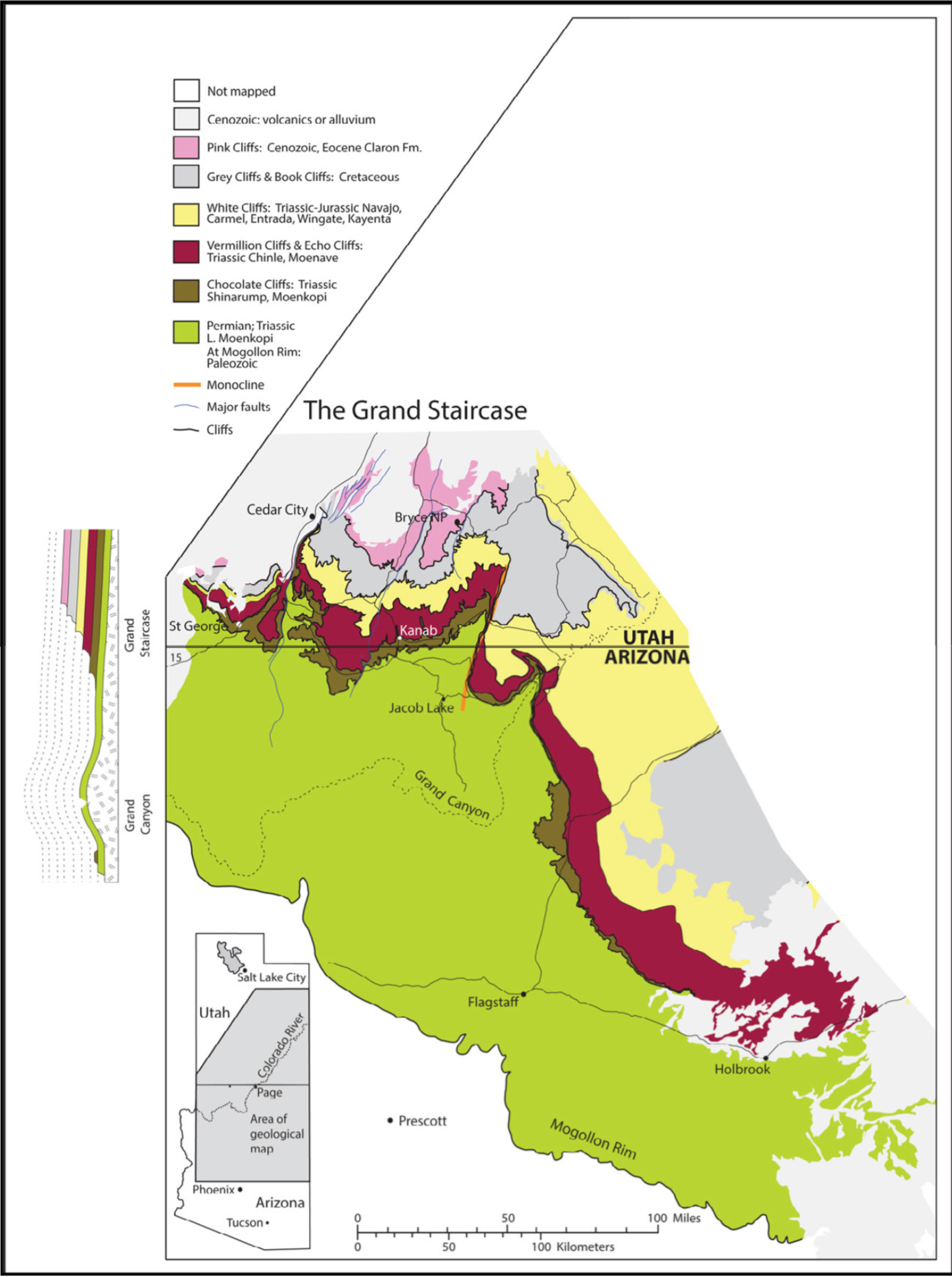
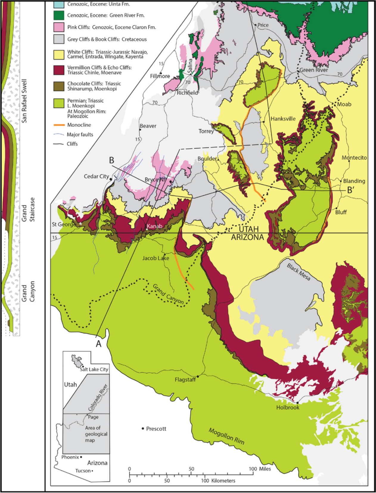
We will come back to that question, but first consider what is the size of this staircase feature. Figure 7 shows how the staircase is often shown, with its southern margin at the Grand Canyon or at the northern edge of the Kaibab uplift (approximately the Arizona border).[5]
Figure 7. A map of the Grand Staircase as it is often described, with its southern border at the Grand Canyon. Another portrayal has the Stair-case ending farther north, near the Arizona border. In Figures 7-10, and 12 the inset on the left side shows a cross-section of the sediments in the Grand Staircase.
Much of this territory is included in Grand Staircase National Monument. However, the Grand Canyon is just a giant gash across an uplifted part of the landscape, and the same Paleozoic formations continue south (and get thicker) until they end at the lowest step in the staircase – the Mogollon Rim in central Arizona. Figure 8 shows the size of the Grand Staircase when this area south of the Grand Canyon is included.
Figure 8. A map showing the geographical extent of the Grand Staircaseif we accept the Mogollon Rim in central Arizona, where the Paleozoic formations end, as the lowest step in the staircase.
In reality there is even more to the Grand Staircase. If we follow the upper cliffs indicated by the colored bands, they go north and then to the east through northern Utah. Above them are two more levels of rock formations, the Uinta and Green River Formations (Fig. 9). The Grand Staircase actually is a series of cliffs, one above the other, beginning in northern Utah and dropping down, one step at a time, all the way to the Mogollon Rim across central Arizona, and this staircase also extends into part of western Colorado (not covered in our illustrations). This area includes most of what is called the Colorado Plateau.
Figure 9. A map showing the geographic extent of the Grand Staircase if we put its southernmost border at the Mogollon Rim, and if the Green River Formation in northern Utah is recognized as the actual northern end of the Staircase. In Figures 9, 10, and 12 line A to A’ shows the location of the cross-section pictured in the insets on the left side of the figures.
It is not clear how far south the Uinta and Green River Formationsoriginally extended. They probably did not go as far south as the other formations are believed to have extended, but in some areas the Green River Formation ends abruptly in a very high, precipitous cliff (Figure 4, upper left), like the other cliffs in the Grand Staircase. This raises the same questions about the origin of this cliff that are pertinent to the other cliffs.
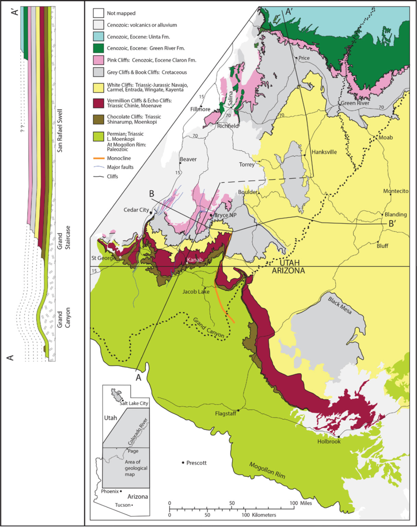
This northern part of the picture does not appear to be quite as clear, because of irregular features in central Utah that complicate the nature of the steps. These include the San Rafael Swell, the Circle Cliffs, and the Teasdale Uplift. But these are not as disruptive to the staircase pattern as they may appear at first. These features are just uplifted areas, like bubbles, that pushed the rock formations up, accompanied by erosion that removed the central areas of each bubble. If we could just flatten these out – iron out the wrinkles in the landscape – the picture would be clearer. Fortunately we can do that with the help of Adobe Illustrator, as in Figure 10.
Figure 10. A map of the Grand Staircase when the complexities of several uplifted regions are digitally removed, as if these bubbles in the landscape were ironed out, to give a clearer view of the nature of the Staircase.
Without these wrinkles the steps go consistently up as we proceed north, to the upper step in northern Utah, with the middle Mesozoic red rock country extending through the central area of Utah. There are also several mesas composed of remnants of Cretaceous rocks that were not removed by erosion.
PROPOSING AND TESTING HYPOTHESES
Conventional thought among geologists generally follows the philosophy of Methodological Naturalism, and uses that as a basis for developing hypotheses to explain the phenomena they are studying.[6] Can we use our biblical worldview in the same way, as a basis for developing hypotheses to explain, e.g., the erosion of Utah and Arizona to form the Grand Staircase? Our logic can be clarified if we follow Chamberlain’s recommendation of multiple working hypotheses,[7] and define two or more hypotheses for the shaping of the Grand Staircase, basing some on the concepts of conventional geology and others on a biblical view of earth history. Then our research can seek to open-mindedly compare the hypotheses, and search for data with the potential to test between them. That is a valid and constructive approach to a scientific question. There is another side to that. As Thomas Kuhn suggests, a new idea, no matter how good it is, may never have a fair chance to succeed unless a few persons believe in it enough to diligently seek to develop and apply it in their research.[8] So let us do what he suggests, and proceed with these hypotheses.
1. Landscape formation, including the Grand Staircase, in one catastrophe, at end of a global flood. 2. Series of such catastrophic erosion events, at end of the flood. 3. One catastrophe later, possibly in association with glaciation. 4. A series of such catastrophic erosion events, perhaps in association with glaciation rather than at the end of the global flood. 5. Erosion by fluvial processes (rivers) and rain, as occurs today, over ~ 5 million years. 6. Erosion by fluvial processes, somewhat more extreme than normal, but still over millions of years.
For our purposes we can simplify these into two working hypotheses:
Working hypothesis one (based on initial hypotheses 5 or 6): the erosion of the Grand Staircase occurred by processes similar to those we observe today, over millions of years. Since this erosion occurred sometime after the Green River Formation was deposited, there was no ocean in Utah at that time. There was the enormous Lake Bonneville, which drained catastrophically, but that is to the west of our study area.[9] So the erosion of the Grand Staircase would have to be the result of fluvial (river-related) processes. But there is a significant problem with that explanation. A river cuts a channel or a wider flood plain with a bank on each side (Fig. 11), and does not carve a series of steps as in the Grand Staircase.
Figure 11. A river and the cliffs on each side of the river. Rivers and the valleys they erode are not always this dramatic, but a river cuts a channel, and eventually a flood plain, with cliffs or hillsides on each side of the channel.
Thus river erosion does not seem to be a likely process for carving the steps. This conclusion is supported if we add the primary river drainages to the map (Fig. 12). The rivers do not follow the steps in any way that seems likely to have cut the steps. In fact in a number of cases the river drainages cut right across the large landscape features.
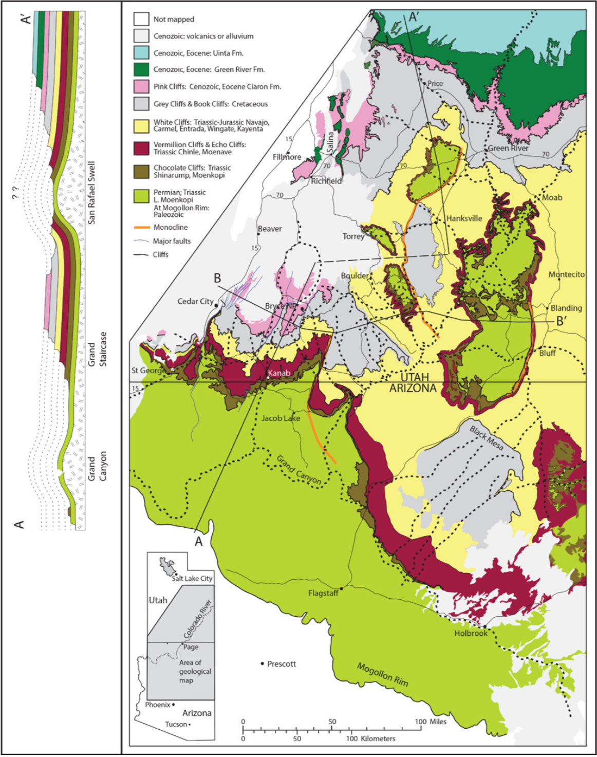
Figure 12. The entire Grand Staircase, with the uplifts included, with the primary river drainages shown in heavy dotted lines.
However, we must consider this possibility carefully. It could be suggested that river erosion formed the staircase pattern as the Colorado Plateau region was gradually uplifted. The first proposed step in this process would occur after a partial uplift of the region. Rivers then meandered widely across the landscape, according to this explanation, eroding much of the region down to a stable base level. Then several hundred feet of further uplift resulted in a somewhat smaller region again being eroded down to a new stable base level. If this happened several times, it could be proposed, this could result in the staircase as we see it now. If this occurred, it would involve meandering rivers fairly uniformly eroding several thousand square miles at each step in the process, followed by an episode of uplift and then a repeat of the erosion process. Is this repetitive uplift and erosion process likely? Can we find evidence of these meandering river systems in the plateaus of the Grand Staircase? There is a paper describing one Miocene river in northern Arizona that is no longer a river.[10] Is there evidence for the multitude of such paleodrainages that would be required to form the Staircase?
There is another significant challenge for this scenario. The process would have to erode away any evidence of the southern “bank” of the river valley or flood plain where this occurred, leaving only the south-facing cliffs that would have formed the northern bank of the system. Is there any evidence, or a likely hypothesis for the disappearance of the southern flank of such an ancient river system? This scenario must be considered, but I suggest that the evidence presented here suggests that a different process is required to explain the Grand Staircase.
Figure 13 is an attempt to think what we might expect the Utah/ Arizona landscape to look like if it was eroded by fluvial (river) processes. If the Grand Staircase had been carved by river systems there should be an evident relationship between the rivers and the shape of the landscape, but the actual cliffs do not show such a relationship to the existing river systems. The evidence we have looked at does not seem consistent with working hypothesis one – forming the cliffs by river erosion, as it occurs in the modern world.
Figure 13. One hypothesis of how the Grand Staircase region might appear if it had been shaped primarily by fluvial (river) erosion, rather than catastrophic water flow. This is one of the hypotheses to be examined by careful geomorphological research.
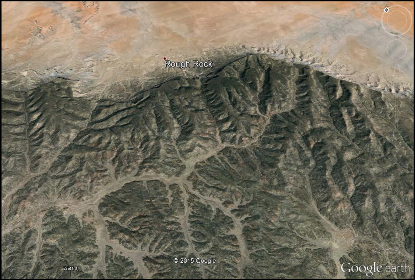
Figure 12 shows Black Mesa, in northeastern Arizona, a remnant of Cretaceous formations, that were mostly removed by erosion. The drainage on top of the mesa is toward the south (Fig. 14).
Figure 14. A photograph from Google Earth showing the top of the northern part of Black Mesa. The dendritic pattern of valleys can be seen, with a smaller dendritic pattern of rivers in each valley, draining toward the south.
There are wide valleys there with dendritic drainage patterns within each of these valleys. They don’t drain over the northern edge of the mesa, but drain to the south. If we look at the mesa wall from the northeast (Fig. 15) these valleys appear as hanging valleys (or beheaded valleys).
Figure 15. A view from the ground, of the NE side of Black Mesa, showing some of the hanging valleys (or beheaded valleys) that end at the cliff. Drainage in these valleys is toward the south.
It appears as if the valleys were formed before the rock formations forming the mesa were eroded away from the area north of the mesa.[6] Then the drainages on top of the mesa continued to drain to the south. This also is consistent with the other evidence discussed above, that questions whether river-related processes provide adequate explanations for the origin of these landscape features.
Now consider working hypothesis two (based on initial hypotheses 1-4): The rock formations covered Utah and northern Arizona as indicated by the dotted lines in Figure 1. Then catastrophic water flow (one or more events) on a massive geographic scale flowed over the Colorado Plateau with the energy and erosive processes to rapidly erode back the formations, moving the cliffs or scarps back to the north, one after the other (Fig. 6). If the water flowed from the north, headward erosion began cutting at the south, proceeding back to the north, with the southern area eroded more deeply to form the lowest of the steps. Or the erosion could have followed a different pattern, but whatever the specific pattern, the Grand Staircase was cut into the landscape by one or more of these catastrophic events. If this occurred, careful research may possibly find evidence for the direction and pattern of water flow that produced the existing landscape.
The hypothesis that best fits the evidence is large-scale water flow that shapes the landscape features, often cutting channels across these features, and rivers only cut the final touches into the landscape (working hypothesis two), as in Figure 16. In this hypothesis the southward drainage system on Black Mesa was established when the mesa still extended farther to the north. I propose that the catastrophic erosion removed the former northern extension of the mesa, leaving the hanging valleys as remnants of the original drainage pattern.
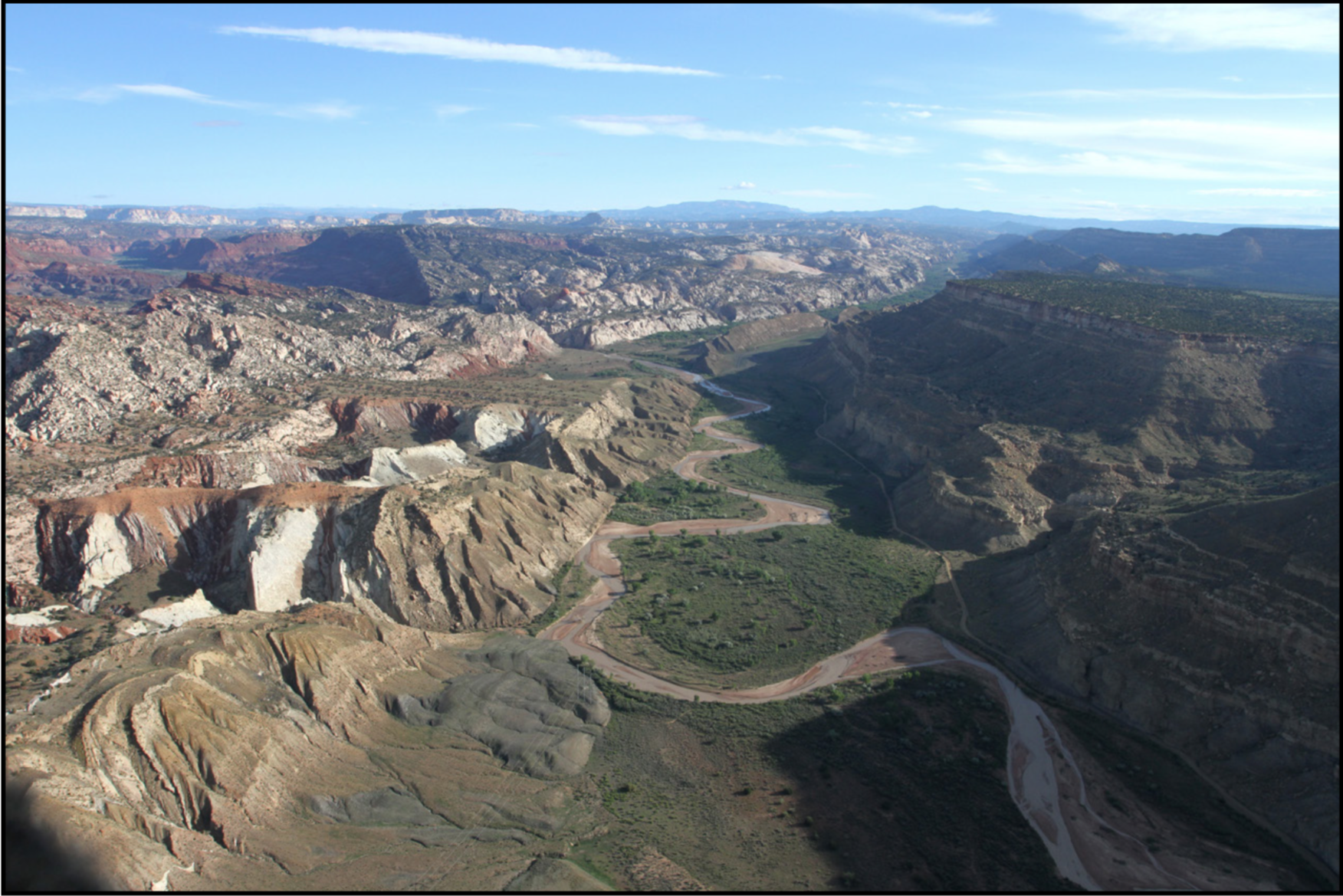
Figure 16. A view of the Cockscomb monocline, looking north. The river near the lower middle of the photo cuts a channel across the monocline, from the west, and then meanders down the pre-existing valley along the east side of the monocline. This is best explained if the river did not form the monocline, but developed its drainage path after the monocline was formed, and only modifies minor features of the monocline structure.
The southern edge of the series of cliffs in the Grand Staircase is very irregular. Is this contrary to the explanation I am suggesting? Was the erosion of the steps controlled by structural features like faults and folds? There is a series of faults and folds that are a prominent feature of southern Utah geology. However, these features are all north-south trending geological structural features, as shown in cross-section in Figure 17.
In the western part of the staircase are three major north-south faults, and in each case the sediments are raised up on the east side of the fault. Then farther east from these are three prominent monoclines, which in each case are folded up toward the west.[11] These dramatic features are shown in Figure 18. Since they are oriented north-south, they could not be the cause of the staircase, but actually cut across the steps in the staircase. The faults and folds are irrelevant to the origin of the staircase pattern. The staircase cliffs have only been shifted in north-south directions by these structural features, but not formed by them.
On the east side of the Cockscomb monocline the Triassic and Jurassic formations that make the cliffs to the west have gone underground, but the cliff topography continues to the east as two prominent cliffs in the Cretaceous formations. The lower of these cliffs is continuous with, and contains the same rock formations as the Straight Cliffs on the east side of that area (Fig. 19). It can be suggested that the same large-scale water flow that formed the Grand Staircase also carried the cliff pattern across these Cretaceous formations.
AN ALTERNATIVE EXPLANATION
Another explanation for the cliffs of the Grand Staircase is presented by Schmidt.6 Using geological observations in the Colorado Plateau he concludes that each of the steps has eroded back (scarp retreat) at rates of 1 to 9 kilometers per million years. He bases this on careful logic and observations, so it cannot be just brushed off. However, his conclusion is based on, and dependent on two assumptions that are not directly stated in the paper, but are clear from his presentation of data and interpretations. One assumption is that the scarp retreat process occurred through processes consistent with what is generally active today (he does not discuss the exact nature of the process in this erosion). But the evidence I have presented above raises doubts about the adequacy of these modern fluvial processes to explain the origin of the enormous staircase-like series of cliffs, which drop down consistently in one direction.
The other assumption is his acceptance of the radiometric time scale, which is the basis for his time calculations. That time scale is not consistent with a Bible-based worldview, but there is nothing in my analysis of the staircase phenomenon that can address the time issue. If we leave aside for now the question of time, the physical evidence described above still strongly suggests that his model is not adequate to explain the evidence, no matter what the time scale.
How could Schmidt and his colleagues be so wrong? Are they practicing careless science? I see no evidence of that. The existence of two such radically different models for formation of the Grand Staircase can only be understood if we consider the dominant role of worldviews in our approach to such scientific questions. If a geologist is fully convinced that the conventional, naturalistic explanation of earth history is correct and the only viable scientific approach (most of them are so convinced), that philosophy rules their scientific thinking on the big questions of history. To consider the possibility that biblical catastrophism could suggest explanations worth a second thought is not generally going to happen. Only someone with personal confidence that the God of the Bible knows more about geology than we do will take seriously a geological model that is initiated or encouraged by a biblical worldview. Even if such a model is absolutely correct, it will not succeed unless there are logically thinking, properly educated persons with the determination to develop the model and apply it in research.
DISCUSSION
Have I proved my conclusions about the origin of the Grand Staircase? No, certainly not, but I predict that working hypothesis two will be found to be going in the right direction, and clearly is most consistent with the data. Even though our discussion of the origin of the Grand Staircase arose from a religious perspective, it resulted in these testable hypotheses – testable by careful study of the geomorphological evidence. I suggest that this project illustrates how a biblical worldview can be an effective platform for scientific thinking and hypothesis development and testing. An alternate worldview, applied consciously and deliberately as we have done in this project, can lead to constructive, even better hypotheses. I propose that there are many geological or biological questions to which this worldview, applied consciously and deliberately, can lead to better understanding, or at least to deeper testing of the concepts being studied. The hypotheses that we propose may be supported by such research, or the research may lead to better hypotheses that can also be tested. Either way will result in improved scientific understanding, as our alternate hypotheses provide the incentive and some suggestions for further research. W. M. Davis, a prominent geologist encouraged the pursuit of what he called “outrageous hypotheses,” since most really new ideas in geology will seem outrageous at first.[12] He may not have been willing to accept my hypothesis on the Grand Staircase as a legitimate outrageous hypothesis, but I propose that his concept can be appropriately expanded as I am doing.
Some individuals may be reticent to approach research in this way, because they have seen some biblically-oriented scientific research that was done in a shallow way. Actually there has been shallow research done on all sides of the philosophical spectrum, so that is not an adequate reason for avoiding a novel approach. Quality research has also been done in all of those quarters. Careful work, testing multiple hypotheses, is essential and will lead us in the right direction.
This paper presents a preliminary analysis and suggests hypotheses for testing. This is not a finished conclusion, but proposes an idea that can lead to extensive field geology research, and also experimental modeling, on the question of scarp retreat and the erosional history of the Grand Staircase – an opportunity for productive research that would probably not occur if our biblical worldview did not lead us to think it provides constructive insights. I will not be the person to pursue this research, considering what stage of my career I am in. I hope someone does take up the awesome opportunity for research presented by the Grand Staircase, and seeks better explanations for its origin.
ENDNOTES
[1](a) Brand L, Chadwick A. 2016. Faith, Reason, and Earth History: A Paradigm of Earth and Biological Origins by Intelligent Design. 3rd ed. Berrien Springs, MI: Andrews University Press; (b) Brand L. 2015. Worldviews and predictions in the scientific study of origins. Origins 64:6-20; (c) Brand L. 2015. Naturalism: its role in science. Origins 64:21-37.
[2]Tarbuck EJ, Lutgens EK. 2017. Earth: An Introduction to Physical Geology. 12th ed. New York: Pearson Education, p. 216.
[3](a) Hintze LF. 1980. Geological Map of Utah. Utah Geological and Mineral Survey; (b) Wilson ED, Moore TR, Cooper JR. 1969. Geologic Map of Arizona. Arizona Bureau of Mines and the U S Geological Survey.
[4]Mallory WW (ed.). 1972. Geological Atlas of the Rocky Mountain Region. Denver, CO: Rocky Mountain Association of Geologists.
[5]Doelling HH, Blackett RE, Hamblin AH, Powell JD, Pollock GL. 2000. Geology of Grand Staircase-Escalante National Monument, Utah. Geology of Utah’s Parks and Monuments, Utah Geological Association Publication 28.
[6]Schmidt K. 1989. The significance of scarp retreat for Cenozoic landform evolution on the Colorado Plateau, U.S.A. Earth Surface Processes and Landforms 14:93-105.
[7]Chamberlin TC. 1965. The method of multiple working hypotheses. Science 148:754–759 (republication of the original article from Science, 7 February 1890).
[8]Kuhn TS. 1970. The Structure of Scientific Revolutions. 2nd ed. Chicago: University of Chicago Press.
[10]Lucchitta I, Holm RF, Lucchitta BK. 2011. A Miocene river in northern Arizona and its implications for the Colorado River and Grand Canyon. GSA Today 21(10):4-10.
[11]A monocline is a fold in the geological formations, folding up in one direction and then leveling off, as in the inset in Figure 17, Waterpocket Fold.
[12]Davis WM. 1926. The value of outrageous hypotheses. Science 63:463–468.