The eruption of Mount St. Helens has become a unique opportunity to study rapid geologic activity. Miles of forests were blasted down, giant slides and debris flows changed the topography of the Toutle River Valley, and new lakes were formed. At the base of the mountain, a larger Spirit Lake now supports a huge log raft. Some of the logs are floating erect or are sitting upright on the bottom. Some past geologic phenomena such as the series of petrified forests of Yellowstone may be explained in part by the study of this eruption and its associated activities.
Few geologic events in recent times have attracted more attention than the eruption of Mount St. Helens. In addition to the spectacular eruption that destroyed environments and human life, interesting associated phenomena with important ramifications for the understanding of past geologic history are being studied.
On May 18, 1980, Mount St. Helens erupted with a roar heard 200 miles away and a force equal to 500 Hiroshima atomic bombs [1]. Enough ash and rock were moved to provide a ton for every person on earth. A blast of ash-charged superheated gas was flung northward killing 61 humans and thousands of animals [2]. Millions of trees in 240 square miles of prime forest were blown down or killed [3].
The eruption that removed over 1300 feet from the top of the beautiful mountain was triggered or preceded by a 4.9 magnitude earthquake [4]. The immediate result of the jolt was a massive avalanche down the north face which had been bulging at a rate of 5 feet per day for several weeks [5]. The eruption following the slide eviscerated the mountain, leaving a crater 2000 feet deep. A resort lodge and thirty cabins were pulverized and buried under 300 feet of sediments.
The rapid melting of snow fields and glacial ice and the heavy rainfall that accompanied the eruption soon filled both forks of the Toutle River with flooding crests of mud that picked up huge piles of logs awaiting transport to sawmills. This chaos of logs and mud demolished lumber camps and bridges. Three hundred homes in the valley were buried or swept away [6].
Details of the May 18 Eruption
The eruption of Mount St. Helens at 8:32 Sunday morning, May 18, was observed by several people both from the air and from adjacent campsites or logging areas [7]. The northward bulge of the north face of the mountain had been expanding rapidly since at least April 25. By May 18 great fractures had developed all over this vast flank. The 4.9 magnitude earthquake appeared to have been the trigger that brought about the collapse of this unstable face. Photographs fortuitously taken at the moment of collapse show the north face of the mountain sliding down into the North Toutle River Valley in three or four stages [8]. The slippage of this vast section of the mountain, the greatest rock slide ever observed, produced an almost vertical face. Out of this face came a high velocity blast of steam and ash. The result of this directed blast (lateral rather unusual in volcanic eruptions) was the devastation of many square miles of terrain in a 160º arc to the north. The high velocity wind (initially close to 200 miles per hour) [9] produced by the collapse of the mountain was immediately followed by the lateral volcanic eruption. Temperatures in the area adjacent to the summit of the mountain reached as high as 500ºC [10]. After the initial northward blast the eruption changed into a vertical phase, and continued so for several hours. The vertical eruption lowered the south wall of the mountain and, along with the collapse of the north flank, produced a huge crater with the rim approximately a mile in diameter and at least 2 miles long.
The Debris Flow and Stump Transportation
The debris flow, a curious geologic phenomenon, that began to move down the north fork of the Toutle River appeared to have been lubricated or buoyed up by a steam layer so that the sediments were little disturbed or mixed. It funneled 15 miles down the north fork at a speed averaging close to 90 miles per hour [11]. The result is a long tongue of sediment with a most unusual hummocky topography.
The very hot rocks (although not molten) that erupted from the mountain caused steam blast craters where they encountered water or wet sediments. Mount St. Helens was clothed with several glaciers. The ice from these glaciers either was thrown out with the rocks or formed great rumbling slides. Where ice was buried by sediments, collapse pits were formed by its subsequent melting. Thus the surface of the North Toutle River Valley is now a terrain of hummocky mounds up to 200 feet high and explosion and collapse pits some 100 feet deep [12]. This is truly a unique terrain that gives occasion for visitors such as former President Jimmy Carter to liken it to a lunar landscape after flying over it. Without doubt it will be an area of great geological interest and research for many years to come.
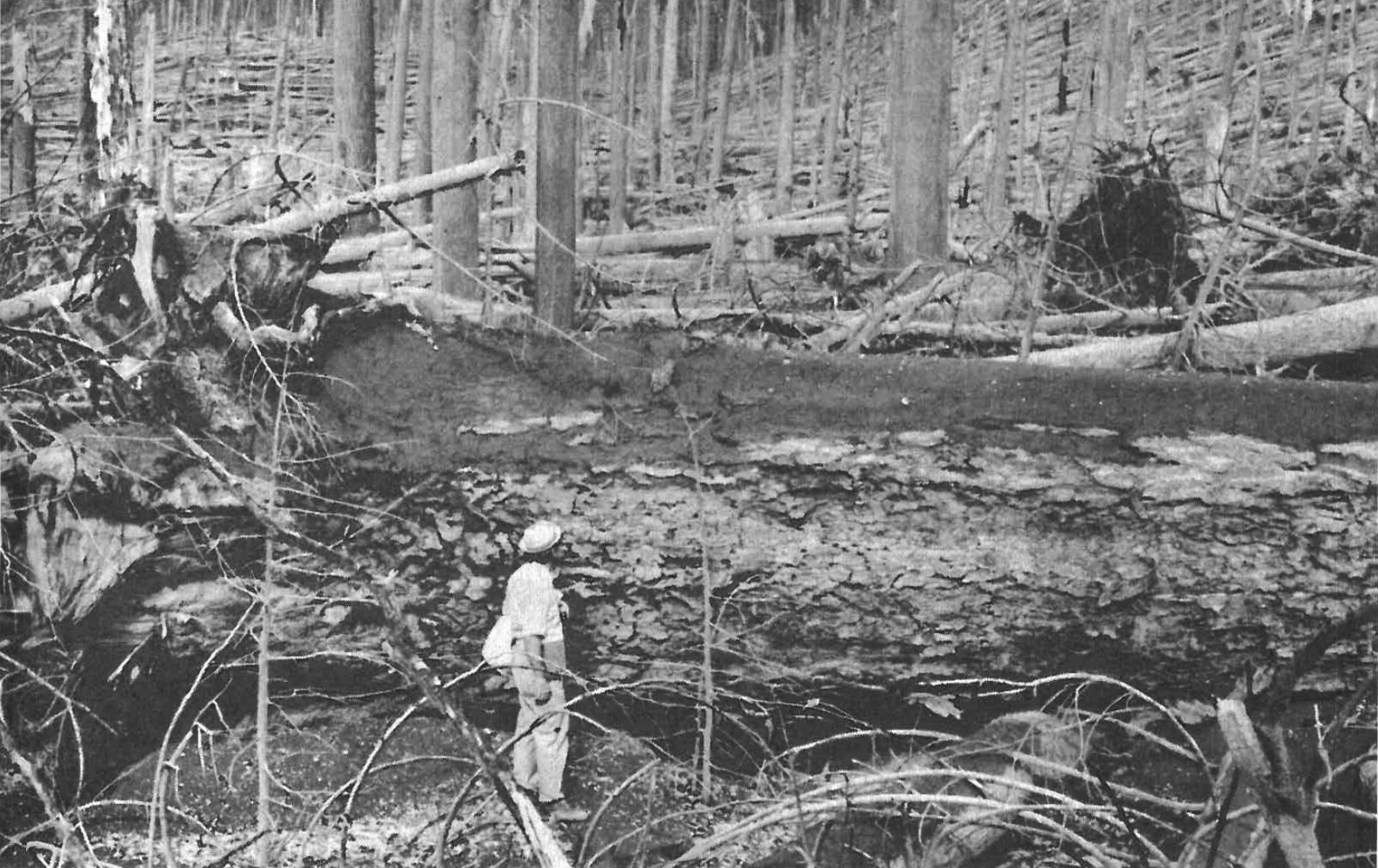
In the area north of St. Helens the forests were devastated. Huge trees, some of them 7 feet or more in diameter, were felled like matchsticks. The areas closer to the mountain showed blast destruction without much regard for the topography although trees on the south-facing slopes were more completely destroyed or removed than those on the north-facing slopes. Areas farther from the mountain showed effects of the topography where the blast was channeled down valleys. In some basins there actually appeared to be occasional backward turbulent curling of the blast to topple trees toward Mount St. Helens.
FIGURE 1. One hundred and fifty-seven square miles of forests were blown down and destroyed. Large trees (7 feet in diameter in this example) were toppled over. Others were snapped off above the roots.
Between the blowdown area and the green intact forest was a relatively narrow zone of scorched standing trees. The demarcation between the blowdown area and the undisturbed forests was extremely sharp in most cases. Experiments done by exposing fir needles to heat and noting under the microscope the effects produced demonstrated that trees in the scorched zone had been burned by temperatures ranging from 50-250ºC [13].
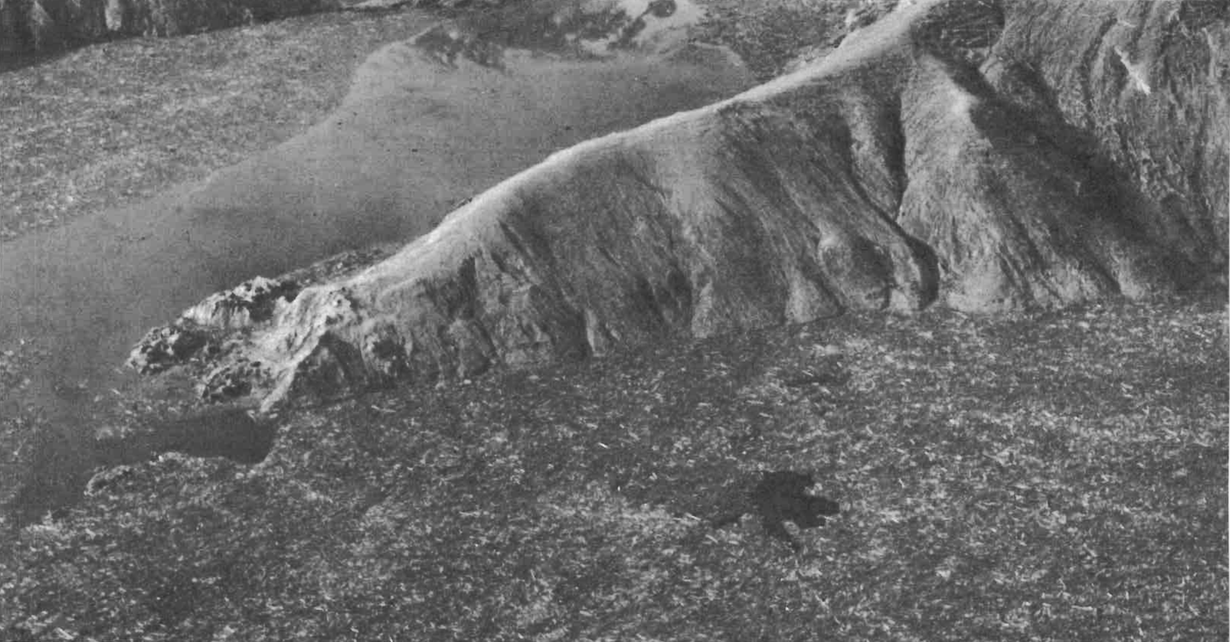
FIGURE 2. Aerial view of Spirit Lake. Most of the visible surface of the lake is covered with logs. The central point of land is largely denuded of trees and soil.
Those who have clambered over the piles of huge trees in the blowdown area and have wandered among the hillocks of the fantastic debris flow in the North Toutle River Valley have been impressed by the power involved in a volcanic eruption. The rapidity of erosion and sedimentation is also most impressive.
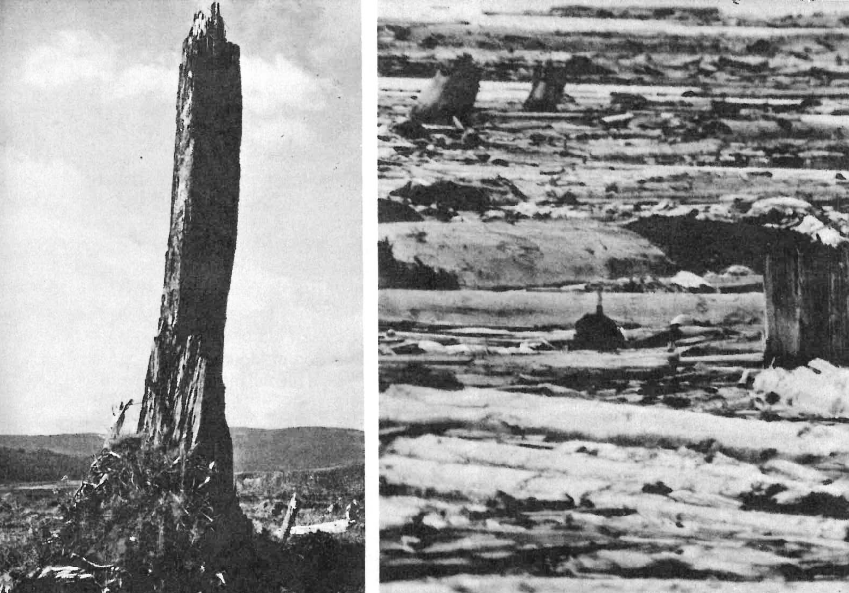
A unique phenomenon associated with the St. Helens eruptions that has helped understand past geologic processes has been the transport of trees and stumps and their deposition in upright position in new locations. The geologic record has numerous examples of vertical petrified trees and stumps. These traditionally have been interpreted as trees in position of growth. Mud slides and turbid floods down the North Fork of the Toutle River have shown a method for upright transport and burial of stumps. Numerous erect stumps in various stages of burial have been scattered on some of the mud flats and gravel bars [14]. One huge stump 7 feet in diameter and 45 feet tall sits on top of newly deposited mud near the end of the 15 mile debris flow.
FIGURE 3. This large stump (7 feet in diameter and 45 feet tall) was transported by the debris flow and left standing on the surface near the toe. FIGURE 4. A SCUBA diver threads his way through the maze of logs and stumps in Spirit Lake.
The Trees in Spirit Lake
Those who believe in a major world catastrophe in the past history of the earth are unable to make good comparative studies because no modern analog exists. Would a global flood remove by erosion large quantities of trees with their root systems and transport and deposit them upright?
Most trees seen in rivers and lakes are logs without roots floating horizontally. Opportunities for observations on significant numbers of floating stumps with roots have been few. In casting about for a modern (if local) example, I thought of Spirit Lake at the base of Mount St. Helens. Here is a large body of water supporting thousands of trees, many of which still retain their root systems. Perhaps research at Spirit Lake could throw light on the flotation characteristics of trees.
Spirit Lake was a beautiful gem among virgin forests with the majestic mountain as a backdrop. It probably originated during past eruptions of the mountain similar to the current ones. The floor of the north fork of the Toutle River Valley (the outlet for Spirit Lake) was raised by volcanic debris. This natural dam impounded the water that became Spirit Lake. The current eruptions are raising the valley floor still higher and enlarging the area of the lake.
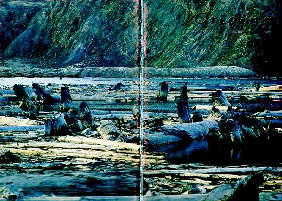
The water from Spirit Lake was displaced 850 feet up the south side of Mt. Margaret by the rock fall and eruption. The backwash of the water carried trees and soil back into the lake. The same backwash ran up the opposite shore of the lake. As a result, oscillations continued for a time and produced unusual erosional features around the lake shoreline and lifted log debris onto hills and elevations now well above water level. The lake now is shallower, higher in elevation and broader in area than it was before the eruption [15]. A huge raft or floating mat of logs and debris covers much of the lake surface. It consists of plant material from chips of bark to trees with trunks 8 feet in diameter.
Access to Spirit Lake since the major eruption of May 18, 1980 had been only by helicopter. In September, 1982, a road was built to the lake from the east. Armed with the necessary permits and safety equipment, I made use of this road the first day it was opened. As soon as we reached the top of the east ridge of hills surrounding the lake and could see its surface, erect floating trees were noticed.
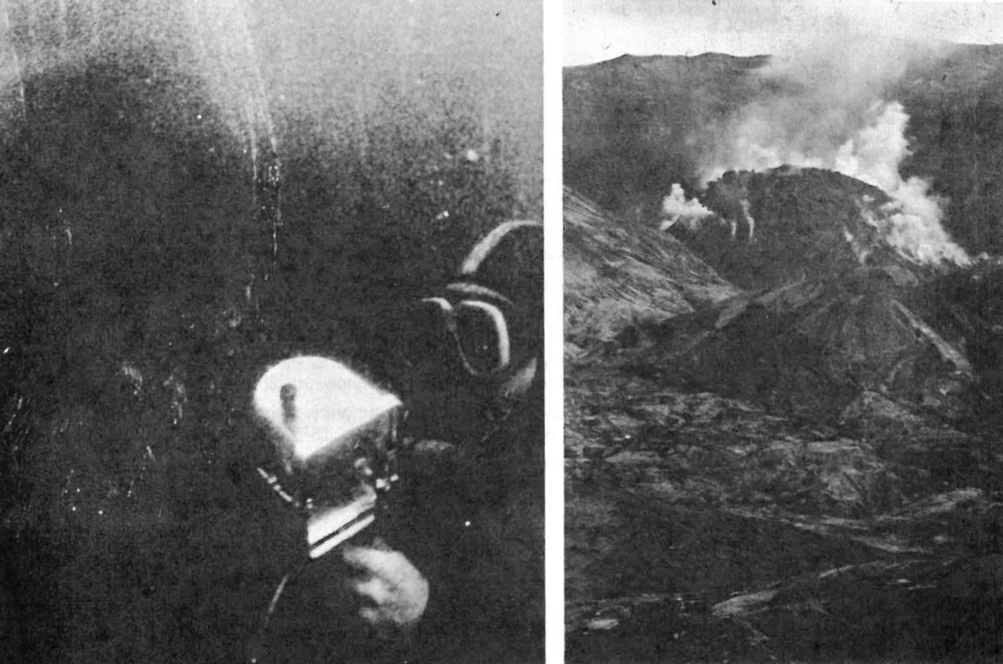
The lower slopes of the surrounding hills were totally denuded of trees, stumps and soil. The erect stumps seen in the water probably were not likely anchored in their growth positions. To be certain that they truly were floating or had drifted into shallow water where they were now grounded, SCUBA divers examined the lower ends of many of the stumps. They found that the root systems were either well above the lake bottom (truly floating) or that they were lightly grounded on the bottom [16]. The latter could be pushed around or even pulled over, whereupon they bounced back into vertical position. Some stumps that had been floating erect were now standing upright on the bottom, their tops well below the surface of the water. Since the water was the color of weak coffee, black when viewed from above, visibility was limited and underwater flash photography was not satisfactory.
FIGURE 5. Underwater photo in murky Spirit Lake of SCUBA diver beside the base of erect floating stump. FIGURE 6. South of Spirit Lake Mount St. Helens' steaming dome warns the observer of possible future eruptions.
Some stumps projected only two or three inches above the water surface whereas others protruded several feet. Two and one half years had passed since the major eruption. How many floating stumps and logs had already sunk to the bottom? The log raft is smaller now than shortly after May 18, 1980 as determined by comparing aerial photographs of the lake. This decrease in size is due to the sinking of some stumps to the bottom. Others, originally floating along the edge of the raft, have been pushed onto the rocks and sand flats along the shore, even as piles of ice are pushed onto shore when wind provides tremendous force against large drifting ice flows in polar regions. Many erect stumps pushed near shore now protrude diagonally from the water surface because the depth is insufficient for them to float upright. When dragged to deeper water, they reassumed their erect stance.
Except for one example, all of the examined erect floating stumps had root balls. In contrast, most of the horizontally floating logs were without roots. This feature may partially explain why some stumps assumed erect positions whereas others remained prone.
Changing wind directions caused the log raft to drift from one end of the lake to another. The horizontal logs provided greater wind resistance and drifted faster, the erect stumps followed more slowly behind. There was a tendency for concentrations of the upright stumps to develop in shallow areas and parallel to the banks. Others were scattered loosely among the log raft or in the open water. At this point in time it does appear that the eruption of Mount St. Helens, with its effects on surrounding forests, is proving to be a helpful model of what could happen to trees in a worldwide flood.
The erect flotation of trees has been observed many times [17]. Experiments on the floating characteristics of plants and trees indicate that if the trees are in the water long enough for saturation and if the water is deep enough, stumps (and even cut logs without roots) will often become vertically suspended in the water or will settle onto the bottom in an upright position [18].
The petrified forests of Yellowstone National Park are buried in volcanic sediments. These sediments were probably derived from lahars (volcanic mud slides), braided streams and turbidites (underwater mud flows) [19]. Erect petrified stumps are found on many levels between the flows. Possible mechanisms for their implacement may be seen in the upright stumps laid down by the Toutle River floods and by the vertical floating of stumps in Spirit Lake. Both mechanisms are not limited to volcanic phenomena. They would apply equally well to any catastrophe involving sufficient water for erosion, transportation and drift of trees. A worldwide deluge would produce optimum conditions. The petrified trees and forests often found in the geologic record may or may not represent trees in situ. Only careful examination of each situation will allow final conclusions to be safely drawn.
Mount St. Helens, the once beautiful mountain with a blue forest-ringed lake at its feet, is now a shattered remnant of its former self and the lake is stark and foreboding. But this loss is partially compensated by the information this volcano is giving us, not least of which is a glimpse of what could have happened to many trees during the Genesis flood. Continuing research will undoubtedly enlarge and refine this picture.
[2]Federal authorities estimate that the eruption of Mount St. Helens killed 1.5 million small mammals and birds, 100 mountain goats, 5,250 Roosevelt elk, 15 mountain lions, 6,000 blacktailed deer, 200 black bears and 441,177 salmon, steelhead and trout.
Ager, Derek V. 1963. Principles of paleoecology. McGraw-Hill Book Co., Inc., New York.
Challenger Expedition. 1885. Report of the scientific results of the voyage of the H.M.S. Challenger during the years of 1873-1876 under the command of Captain Nares and Captain Thompson. Narrative vol. 1. H. M. Stationary Office, London.
Christiansen, Robert L. and Donald W. Peterson. 1981. Chronology of the 1980 eruptive activity. In Peter W. Lipman and Donal R. Mullineaux (eds.). The 1980 eruptions of Mount St. Helens, Washington, pp. 17-30. United States Geological Survey Professional Paper 1250.
Coffin, Harold G. 1971. Vertical flotation of horsetails (Equisetum): Geological implications. Geological Society of America Bulletin 82:2019-2022.
_____________. 1983. Erect floating stumps in Spirit Lake, Washington. Geology 11:298-299.
Crandell, D. R. and D. R. Mullineaux. 1978. Potential hazards from future eruptions of Mount St. Helens volcano, Washington. United States Geological Survey Bulletin 1383-C.
Dorf, Erling. 1960. Tertiary fossil forests of Yellowstone National Park, Wyoming. Billings Geological Society Guidebook, 11th Annual Field Conference, pp. 253-260.
Fayal, Henry. 1886. Etudes sur le terrain bouiller de Commentry. Livre premier; lithologie et stratigraphie. Bull. de la Soc. de l'industrie minerale, 2d serie, 153-4, Saint Etienne. 543 pp.
Findley, Rowe. 1981. Mountain with a death wish. National Geographic. January.
Foxworthy, Bruce L. and Mary Hill. 1982. Volcanic eruptions of 1980 at Mount St. Helens: the first 100 days. United States Geological Survey Professional Paper 1249.
Francis, Wilfrid. 1961. Coal, its formation and composition. Edward Arnold (Publishers), Ltd., London.
Fritz, William J. 1980a. Reinterpretation of the depositional environment of the Yellowstone "Fossil Forests." Geology 8:309-313.
___________. 1980b. Stumps transported and deposited upright by Mount St. Helens mud flows. Geology 8:586-588.
Lipman, Peter W. and Donal R. Mullineaux (eds.). 1981. The 1980 eruptions of Mount St. Helens, Washington. United States Geological Survey Professional Paper 1250. 844 pp.
Ota, Alan K., John Snell and Leslie L. Zaitz. 1980. Mount St. Helens Special Report. The Oregonian, October 27.
Palmer, Leonard. 1980. Mt. St. Helens: the volcano explodes. Northwest Illustrated. Portland, Oregon. 119 pp.
Rosenbaum, J. G. and Richard B. Waitt, Jr. 1981. Summary of eyewitness accounts of the May 18 eruption. In Peter W. Lipman and Donal R. Mullineaux (eds.). The 1980 eruptions of Mount St. Helens, Washington, pp. 53-67. United States Geological Survey Professional Paper 1250.
Rosenfeld, Charles L. 1980. Observations on the Mount St. Helens eruption. American Scientist 68:494-509. September-October.
Sarna-Wojcicki, Andrei M. et al. 1981. Areal distribution, thickness, mass, volume, and grain size of air-fall ash from the six major eruptions of 1980. In Peter W. Lipman and Donal R. Mullineaux (eds.). The 1980 eruptions of Mount St. Helens, Washington, pp. 577-600. United States Geological Survey Professional Paper 1250.
Shangle, Robert D. and Linda Kelso. 1980. Mount St. Helens volcano. Beautiful America Publishing Company, Beaverton, Oregon. 64 pp. Outstanding color illustrations.
Stoffel, Dorothy B. and Keith L. Stoffel. 1980. Mt. St. Helens seen close up on May 18. Geotimes 25:16-17.
United States Department of Agriculture. 1980. Gifford Pinchot National Forest folder on Mount St. Helens.
Voight, Barry et al. 1981. Catastrophic rockslide avalanche of May 18. In Peter W. Lipman and Donal R. Muilineaux (eds.). The 1980 eruptions of Mount St. Helens, Washington, pp. 347-377. United States Geological Survey Professional Paper 1250.
Winner, William E. and Thomas J. Casadevall. 1981. Fir leaves as thermometers during the May 18 eruption. In Peter W. Lipman and Donal R. Mullineaux (eds.). The 1980 eruptions of Mount St. Helens, Washington, pp. 315-320. United States Geological Survey Professional Paper 1250.
COVER PICTURE. Horizontal and erect logs and stumps that constitute the giant log raft on Spirit Lake at the base of Mount St. Helens.