A NOTE ON THE FLOOD/PREFLOOD BOUNDARY IN THE GRAND CANYON
Kurt P. Wise Bryan College, P. O. Box 7585, Dayton, TN 37321 wise@bryancore.org and & Andrew A. Snelling Institute for Creation Research, P.O. Box 2667, El Cajon, CA 92021 aasnelling@ozemail.com.au
ABSTRACT
The most extensive stromatolite horizon known in Grand Canyon sediments is found in the base of the Awatubi Member of the Kwagunt Formation of the Chuar Group. It is suggested that the greater functionality of growing, compared with fossil, stromatolites indicates they were formed by secondary process and not directly created by God. The top-heavy upright orientation of the stromatolites in the Awatubi bed suggests they were formed in situ, which in turn suggests that they predate the Genesis Flood and postdate the Day Three Regression, contra earlier suggestions by the authors (Snelling 1991, Wise 1992). On the other hand, it is consistent with Austin & Wise’s (1994) suggestion that the base of the Sixtymile Formation (overlying the Kwagunt Formation) represents the pre-Flood/Flood boundary in Grand Canyon and Austin’s (1994) suggestion that the Chuar Group was formed in antediluvian times. Good preservation of organics and no preservation of higher organisms suggests that Wise’s (2003) hydrothermal fringing reef model for sediments near Death Valley also applies to Grand Canyon’s correlative Chuar Group sediments and contained Awatubi stromatolites. The Awatubi stromatolites thus formed an intertidal “forest” about hot springs in an intertidal region at the edge of the pre-Flood continent, hundreds of kilometers from land.
INTRODUCTION
In previous publications, the authors (Wise 1992, Snelling 1991) have suggested conflicting interpretations of strata underlying the oldest animal fossils (pre-Ediacaran strata). Wise (1992) suggested an origin on Days Two and Three of the Creation Week, whereas Snelling (1991) suggested a Flood origin. Based upon an examination of the pre-Ediacaran sediments in the Grand Canyon, this paper is official notice of a change in both our positions (see Snelling [1991] and Wise [1992] for discussion).
PLACEMENT OF THE PRE-FLOOD/FLOOD BOUNDARY
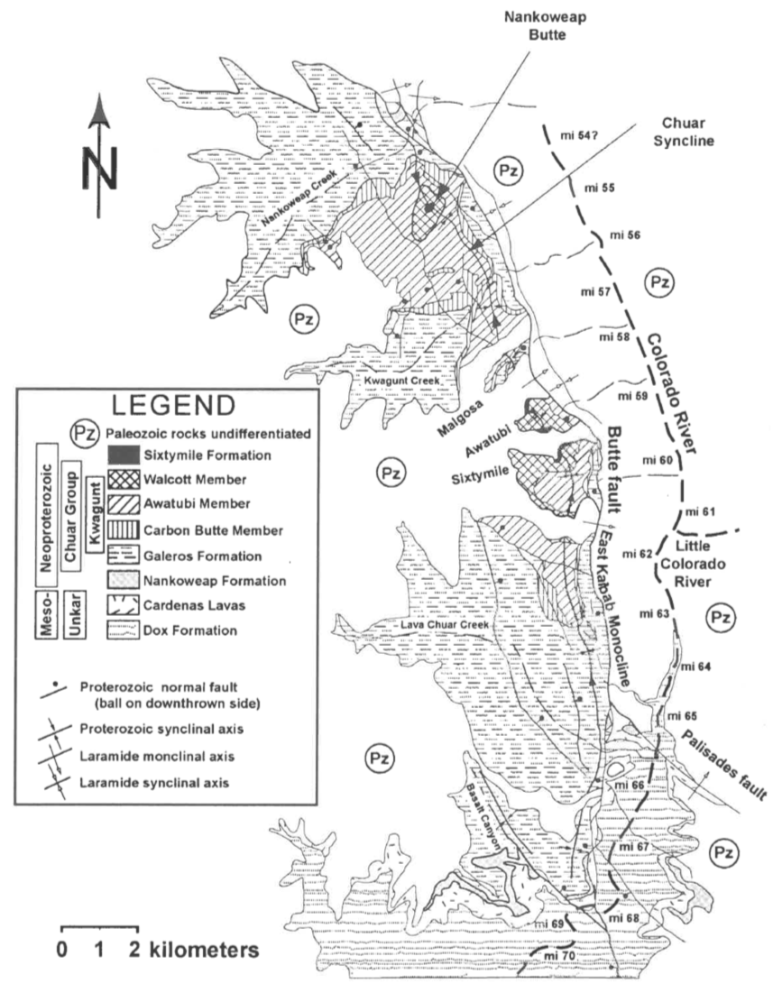
Austin & Wise (1994) introduced a method of identifying the preFlood/Flood boundary at a given location. They maintained that according to Scripture the most substantial catastrophe punctuating earth history was Noah’s Flood. Furthermore, the onset of the Flood, marked by the “breakup of all the fountains of the great deep...on the same day” (Genesis 7:11) would suggest that the events at the very beginning of the Flood were even more catastrophic than subsequent events in the Flood. Based upon this, the pre-Flood/Flood boundary in any local stratigraphic column should correspond to the most significant geologic discontinuity in that column. Austin & Wise (1994) inferred from this that the coincidence of the most significant paleontological, erosional, time, sedimentary, and tectonic discontinuities in a given stratigraphic column should be a good candidate for the location of the pre-Flood/ Flood boundary. Based upon these discontinuity criteria, Austin & Wise (1994) proposed the pre-Flood/Flood boundary in the Grand Canyon should correspond to the base of the Sixtymile Formation (top of the Kwagunt Formation) (see Figures 1 & 2).
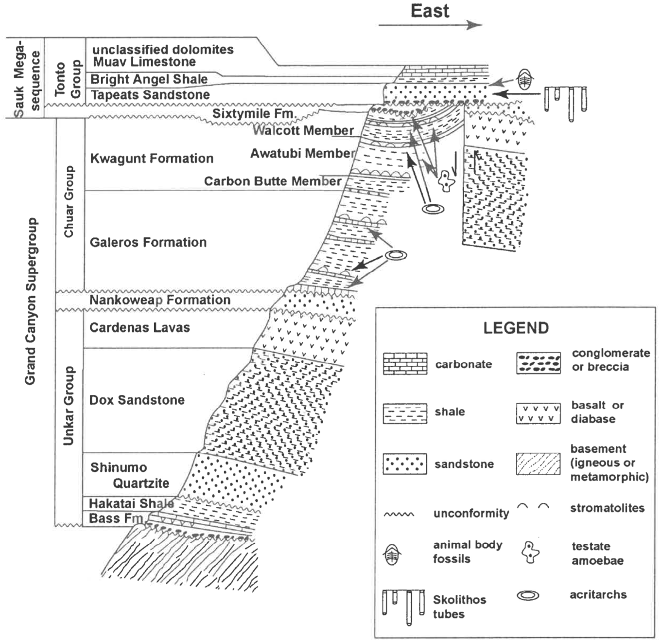
Figure 1. Geologic map of the Chuar Group in eastern Grand Canyon (modified from Timmons et al. 2001, Fig. 4).Figure 2. Stratigraphic outline of Cambrian and Precambrian sediments of eastern Grand Canyon. Thicknesses to scale (modified from Ford & Breed 1972, Fig. 1; Elston & McKee 1982, Fig. 2; Dehler et al. 2001, Fig. 2).
The following points are offered in support of this position:
The most substantial Paleontological Discontinuity in the Grand Canyon is somewhere between the base and the top of the Sixtymile Formation (Austin & Wise 1994). The Sixtymile Formation in the Grand Canyon (see Figure 2) is unfossiliferous. Undisputed multicellular fossils are found only above the Sixtymile Formation (e.g., numerous ichnofossils in the Tapeats Sandstone and abundant animal body fossils in the Bright Angel Shale above that: Ford 1990, Ford & Dehler 2003). Stromatolites are found both above and below the Sixtymile Formation (Ford & Breed 1969, 1973, 1974a,b; Ford 1990; Dehler et al. 2001; Timmons et al. 2001; Ford & Dehler 2003). Acritarchs (fossils of probable algae) are also found both above and below the Sixtymile Formation (Downie 1969, Ford & Breed 1969, Vidal & Ford 1985, Ford 1990, Karlstrom et al. 2000, Dehler et al. 2001, Timmons et al. 2001, Ford & Dehler 2003) (see Figure 2). Just below the Sixtymile Formation, the Kwagunt Formation contains fossils of cyanobacteria (Horodyski 1993) and testate amoebae (Bloeser 1985, Ford 1990, Horodyski 1993, Dehler et al. 2001, Porter et al. 2003, Ford & Dehler 2003). There is therefore a discontinuity in both paleontological abundance and complexity somewhere between the upper and lower bounds of the unfossiliferous Sixtymile Formation.
The second and possibly third most substantial Erosional Discontinuities in the Grand Canyon are at the base and top of the Sixtymile Formation (Austin & Wise 1994). The most substantial erosional unconformity evidenced in the Grand Canyon is at the “Greatest Unconformity” — the erosional surface that separates the crystalline rocks which have the appearance of having been formed at elevated temperatures and pressures, from the sediments of the Canyon formed at surface temperatures and pressures. Second to this erosional event would be the “Great Unconformity” at the top of the Sixtymile Formation, which cross-cuts every formation in the 4,145 m of sediment found beneath it in the Canyon. Possibly the third most extensive erosional event is found at the base of the Sixtymile Formation. Although only 2 m of erosion are directly evidenced by the basal topography of the formation, megaclasts within the formation suggest extensive erosion may have been associated with Sixtymile deposition. Elston (1979) and Elston & McKee (1982) identified limestone megaclasts from a stratum at least 70 m down in the Kwagunt Formation (which Timmons et al. [2001] dispute), and at least one sandstone megaclast which may have come from the upper Nankoweap Formation, almost two stratigraphic kilometers below the Sixtymile Formation.
It is possible — even likely — that the exposure of these lower units occurred in the hanging wall of the nearby Butte Fault. If so, then the Sixtymile Formation megaclasts were generated by substantial mass-wasting-type erosion. Furthermore, the breccia and megaclast content of the Sixtymile Formation suggest both short-distance transport and rapid deposition — all of which could occur very rapidly. It could conceivably be true that the erosion at the base of the Sixtymile Formation is actually an early phase of the erosion at the top of the Sixtymile Formation — that which produced the Great Unconformity. This would suggest that the Sixtymile Formation is itself the result of the second largest erosional event evidenced in Grand Canyon strata. Therefore, the top and bottom of the Sixtymile Formation represent (respectively) the second and third (or possibly even second) largest erosional events in the stratigraphy of Grand Canyon.
The most substantial Time Discontinuity in the Grand Canyon is at the base of the Sixtymile Formation (Austin & Wise 1994). Because they could have been formed centuries before the Flood, many pre-Flood sediments would have been well lithified by the onset of the Flood. Thus early Flood erosion would be expected to have generated extensive conglomerates and breccias containing clasts of pre-Flood sediments. Floodgenerated sediments, on the other hand, probably experienced only limited lithification in the course of a year-long Flood. It would be expected, then, that Flood erosion of Flood sediments would only rarely generate conglomerates of lithified sedimentary material. Plus, even though there would be time after the Flood to lithify sediments, the scale of erosion would be less extensive after the Flood. Therefore, the onset of the Flood might be expected to have generated the most substantial conglomerate and breccia units of sedimentary clasts in the entire stratigraphic column. Included in the lower beds of the Sixtymile Formation are huge angular megaclasts derived from beds in the underlying Kwagunt (Elston 1979, Elston & McKee 1982). Given the angular nature of the clasts and the degree to which the Kwagunt sediments of those clasts stayed together with transport, the Kwagunt Formation sediments seem to have been at least somewhat lithified at the initiation of Sixtymile Formation sedimentation. This suggests that a time discontinuity existed between the deposition of upper Kwagunt Formation and the deposition of the lowermost Sixtymile Formation sediments.
Although the Sixtymile Formation is not the only conglomerate in the stratigraphic column of the Grand Canyon, it and the basal Tapeats contain by far the largest clasts (Elston [1979] reports a block 8 m by 40 m in size; Chadwick [personal communication] reports a Shinumo Quartzite clast in Clear Creek Canyon approximately 80 m in diameter). Therefore, the first and second most substantial time discontinuities evidenced in Grand Canyon strata are found at the top and base of the Sixtymile Formation.
The most substantial Sedimentary Discontinuity in the Grand Canyon is at the base of the Sixtymile Formation (Austin & Wise 1994). The large megaclasts of underlying Kwagunt Formation in the Sixtymile Formation are found beginning only 2 m above the base of the Formation. The megaclasts are piled up at least three deep and separated by meter-thick pebble to boulder breccia layers. Above the megaclasts is found 7-10 m of massive pebble to cobble breccia topped in turn by alternating beds of sandstone and pebble breccia (see also the description of the Sixtymile Formation type locality in Elston 1979). The entire Sixtymile Formation is a conglomerate. This is in substantial contrast to the 2-km thickness of Chuar Group sediments below the Sixtymile Formation (primarily fine clastics with occasional sandstone or carbonate beds). Furthermore, because it contains clasts comparable to those found in basal conglomerate of the overlying Tapeats (see above), the Sixty-mile Formation could be included within the Tonto Group as the initial depositional unit in a fining-upward set of strata. From the base upwards are the Sixtymile Formation megabreccias, Tapeats Formation sandstones, and Bright Angel Formation shales, all capped with the Muav Formation and unclassified carbonates (see Figure 2). This could mean that the Sixtymile Formation is best understood as an early phase of the event which would later deposit Tapeats sediments.
Given the nature of the Sixtymile sediments (i.e., breccia, megaclasts) all the evidence we have is for a brief depositional period for the formation (perhaps a matter of minutes). This could easily be understood to be a very high energy mass wasting phase of a depositional regime which as the energy subsided, would generate Tapeats sediments. This in turn would mean that the unconformity beneath the Sixtymile Formation (and not the one above it) should be understood to be the unconformity bounding the base of the Tonto sequence in Grand Canyon. The biostratigraphic, lithologic, and structural correlations between the Tonto Group and a huge suite of formations up and down the west coast of North America (Stewart 1972, 1991) would suggest that the Sixtymile Formation and Tonto Group above it represent the Grand Canyon expression of an unconformity bounded fining upward sedimentary sequence of continental scale (in North America called the Sauk Sequence). The base of the Sixtymile Formation thus represents a sedimentary discontinuity marking the beginning of a sedimentary sequence of the scale expected in a global Flood.
The base of the Sixtymile Formation may represent the most significant tectonic discontinuity in the Grand Canyon (Austin & Wise 1994). About 1.5 km east of the easternmost exposures of the Sixtymile Formation is the NNW-SSE trending Butte Fault (see Figure 1). West of the Butte Fault the Tapeats Sandstone sits atop the Sixtymile Formation. At about the same distance to the east of the fault, the Tapeats sits atop the Nankoweap Formation. [1] Given that approximately 2000 m of Chuar Group sediments lie between the Sixtymile and Nankoweap Formations, there was at least 2 km of vertical displacement along the Butte Fault (as represented in Figure 2). Note also that this displacement must have occurred before the erosion event evidenced by the Great Unconformity and before the deposition of at least most of the sedimentary package known as the Sauk Sequence. This suggests that the Sixtymile Formation was not only associated with erosional, time, and sedimentary discontinuities, but that it was also associated with a large magnitude tectonic disturbance as well.
The syncline containing the Sixtymile Formation is adjacent and parallel to the Butte Fault (see Figure 1). It is also convex downward and makes up the down-dropped block. It is thus very possible that the syncline is actually a drag fold caused by preTapeats motion on the Butte Fault. Elston (1979) and Elston & McKee (1982) observed that Sixtymile Formation beds thin on the limbs of the syncline as if the syncline was formed before and/or during the deposition of Sixtymile Formation sediments. Although on a smaller scale, the Chuar Group sediments have also been observed to thin in the same way (Timmons et al. 2001). This suggests that pre-Tapeats movement on the Butte Fault began with deposition of the Chuar Group and intensified with the deposition of the Sixtymile Formation.
In the type section of the Sixtymile Formation (where Tapeats Sandstone overlies it), the uppermost Sixtymile Formation sediments (in the core of the syncline) have the same orientation as the overlying Tapeats (Elston 1979, Elston & McKee 1982). As inferred by Elston (1979) and Elston & McKee (1982), this suggests movement along the fault may have been terminated by the time the uppermost Sixtymile Formation sediments were deposited.
Because several of the largest megaclasts have bedding nearly parallel with the containing Sixtymile Formation sediments, Elston (1979) and Elston & McKee (1982) argued that they were probably emplaced by sliding. Their angular nature would further suggest they were not transported very far, so Elston (1979) and Elston & McKee (1982) suggested they probably came from the Butte Fault. Lacking any evidence of time, [2] Elston (1979) and Elston & McKee (1982) thought the Sixtymile Formation was deposited quickly. This suggests something on the order of 2 km of vertical movement occurred on the Butte Fault during the brief depositional period of the Sixtymile Formation. This in turn suggests the Sixtymile Formation corresponds to a very significant tectonic discontinuity (what Elston & McKee [1982] call “The Sixtymile Formation Disturbance”). By comparison, whereas the Great Unconformity above the Sixtymile Formation evidences a remarkable amount of erosion, its level surface over huge distances suggests relatively little tectonic deformation was occurring concurrent with that erosion.
The Sixtymile Formation Disturbance (Elston & McKee 1982) may well be a substantial tectonic disturbance that immediately preceded the great erosional event which resulted in the Great Unconformity. Elston (1979) and Elston & McKee (1982) even suggested that the Sixtymile Formation might be correlated with other early Sauk Sequence landslide deposits elsewhere in North America, such as the Windermere Group of Montana and Idaho. If so, a single tectonic disturbance may have generated large scale avalanche deposits many hundreds of kilometers apart from one another. A tectonic disturbance of such a continent wide magnitude would be consistent with the tectonic upheaval associated with the breaking up of all the fountains of the great deep at the very beginning of the Flood (as suggested by Austin et al. 1994).
If, however, the pre-Flood/Flood boundary is placed at the base of the Sixtymile Formation as suggested by Austin & Wise (1994), this means that pre-Ediacaran (pre-animal) sediments — at least in the Grand Canyon — were formed before and not in the Flood as was suggested by Snelling (1991). Furthermore, placing the boundary here does not answer the question of when before the Flood the Chuar Group sediments were formed — whether, for instance, they were formed in Antediluvian times as suggested by Austin (1994) or during the Day Three Regression as suggested by Wise (1992). For this reason the authors examined the Chuar Group in the Grand Canyon to resolve these differences and answer these questions.
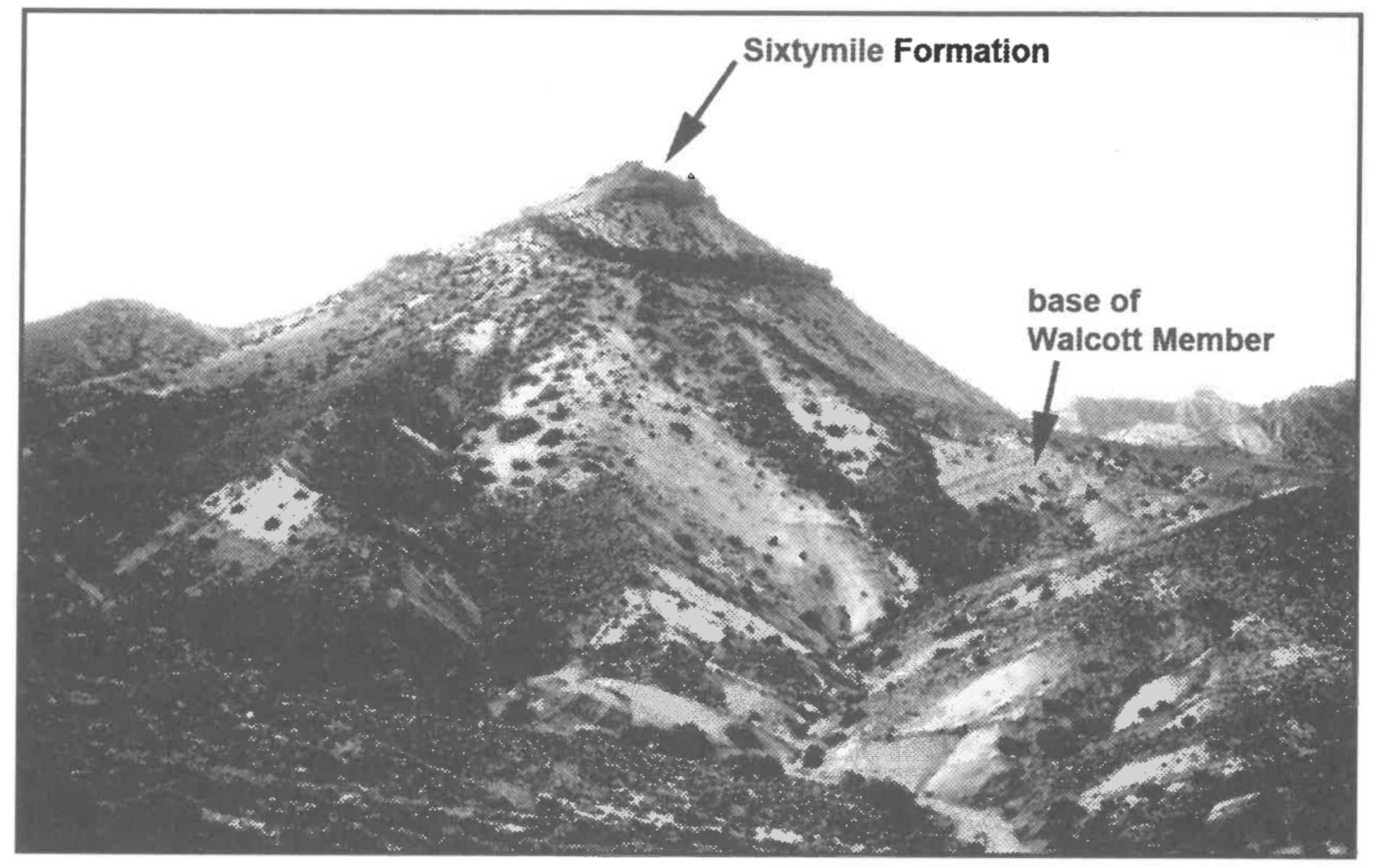
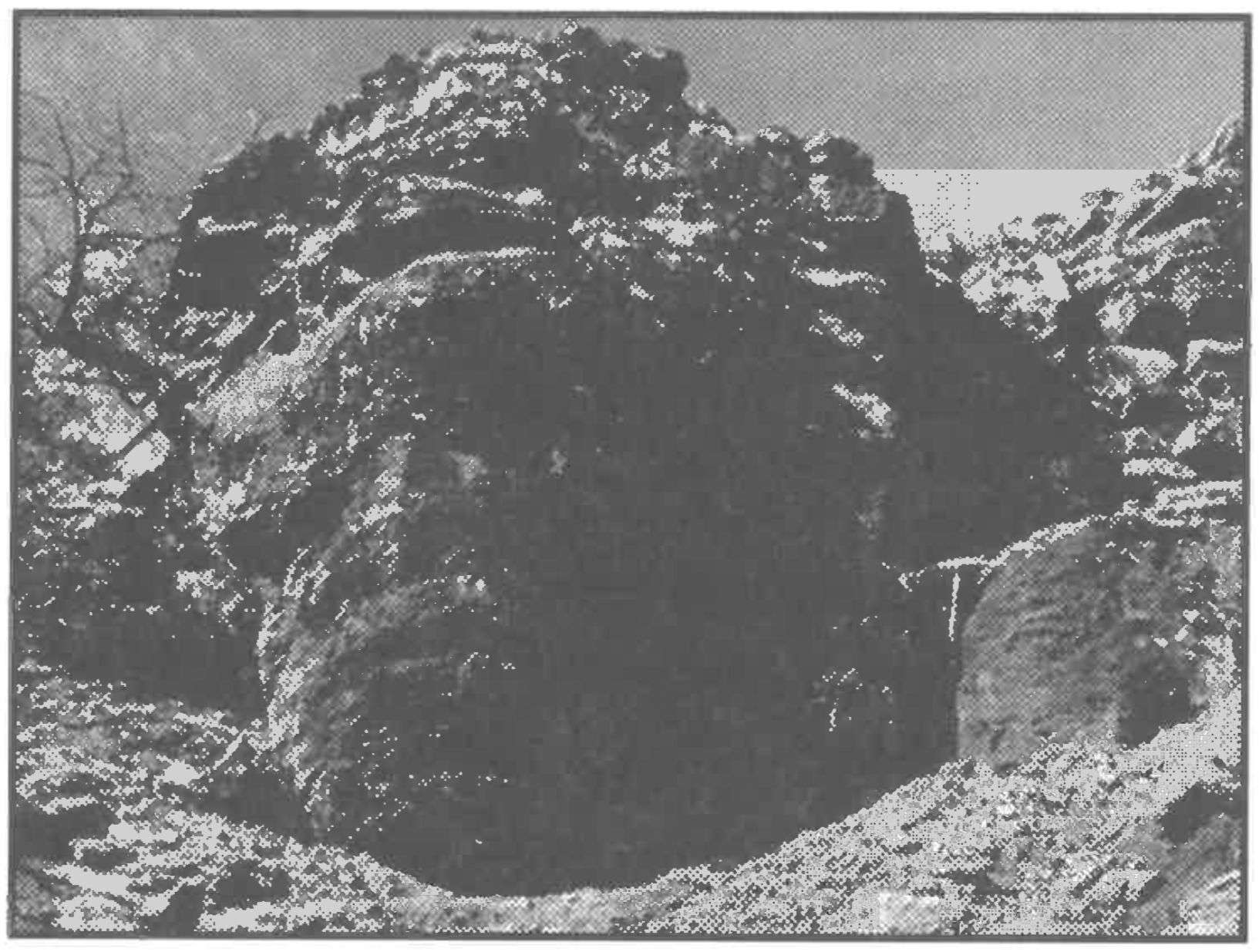
Figure 3. Nankoweap Butte. Photographer is standing just above the stromatolite bed in the basal Awatubi Member. The Sixtymile Formation caps the butte and most of the remainder of the butte is made up of the Walcott and upper Awatubi Members of the Kwagunt Formation (see Figure 2).
IN SITU KWAGUNT STROMATOLITES
In May 2001 the authors examined the Kwagunt and Sixtymile Formations (see Figures 1 & 2) near Nankoweap Butte (see Figures 2 & 3) in the Grand Canyon. Most significantly for the definition of the preFlood/Flood boundary, an extensive stromatolite bed was examined at the base of the Awatubi Member of the Kwagunt Formation [3] (Figure 4). This stromatolite bed is about 635 m below the base of Sixtymile Formation (Ford & Breed 1973), which Austin & Wise (1994) proposed as the pre-Flood/Flood boundary in the Grand Canyon (see Figure 2). Stromatolites in this spectacular bed have the overall shape of unopened toadstools, averaging 2.5 m in height and about 2 m across the top (Figure 5). A typical stromatolite from the bed is composed of a convoluted mass of divergent columns, each commonly 5-8 cm in diameter (Ford & Breed 1969).
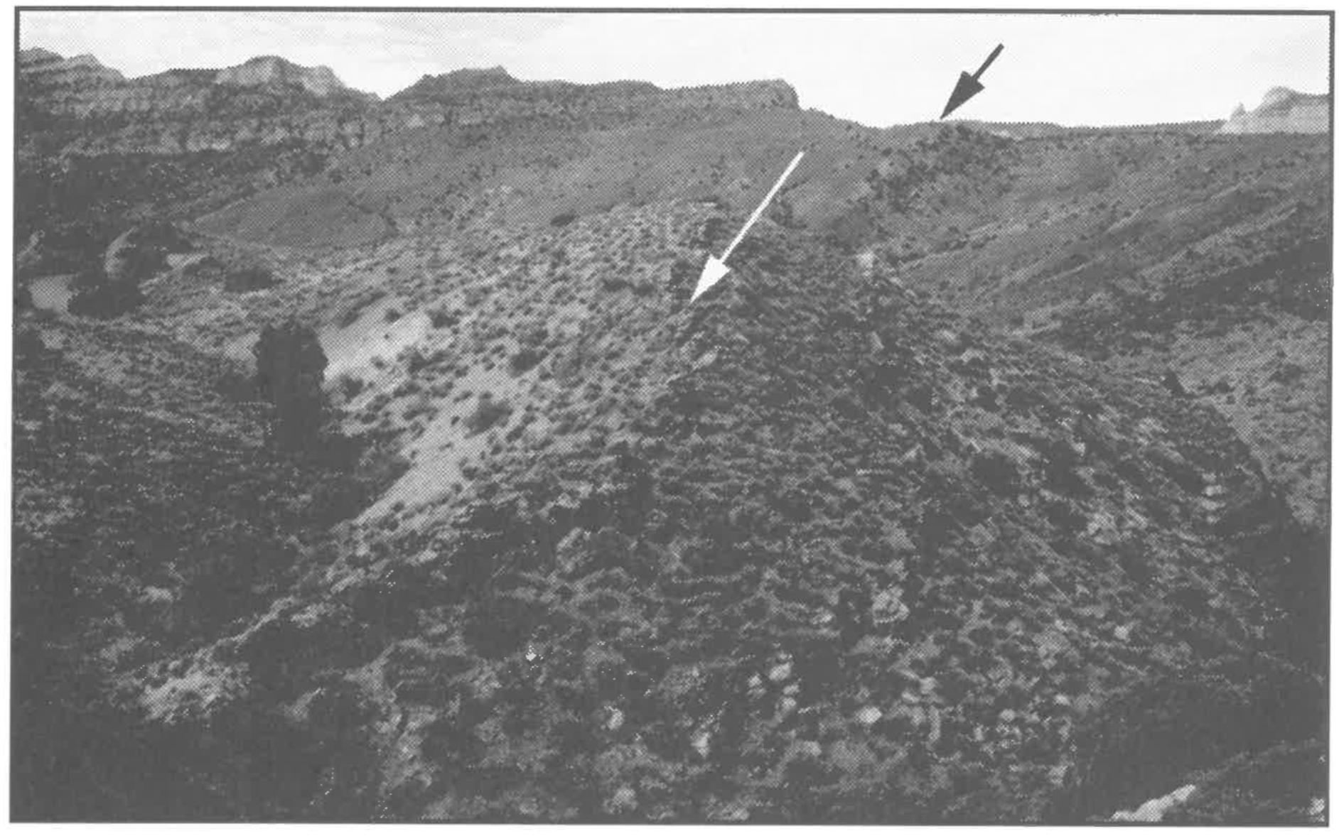
The authors walked the strike of the bed for about 1.5 km, around the east limb of the nose of a south-southeast-plunging syncline. At a distance, the prominent bed could be observed on the west limb of the same syncline for a further 1.5 km or so (black arrow in Figure 4). The average distance between the stromatolites along the entire traverse was less than 1 m (see Figure 4), and many were actually in contact with each other. Each of the hundreds of stromatolites observed in the bed was upright (i.e., with pedestal downward and the head upward; see Figure 5).
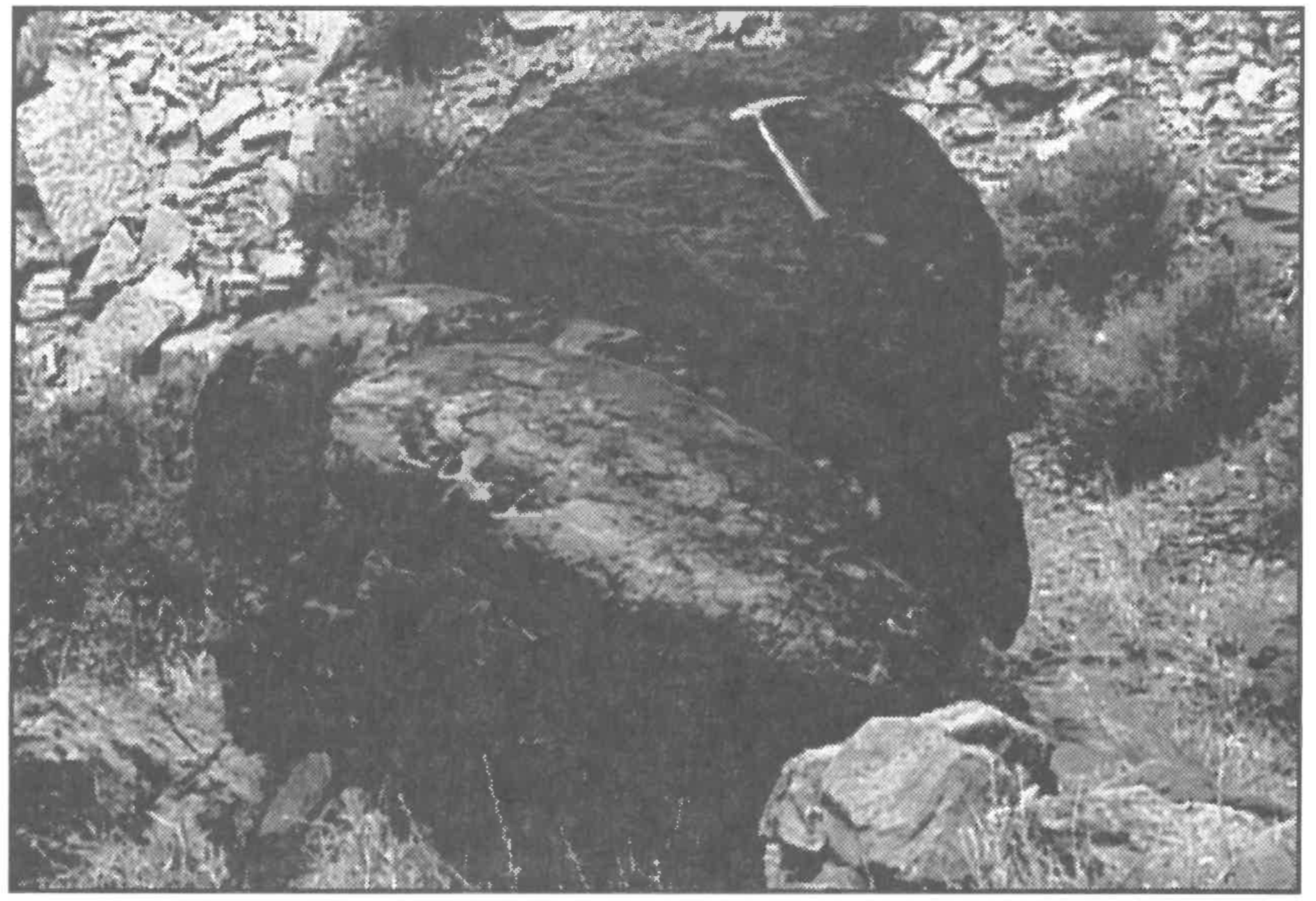
Figure 4. The stromatolite bed. The arrows indicate the location of the stromatolite bed at the base of the Awatubi Member, Kwagunt Formation. Individual stromatolites distinguishable in the lower left corner of the photo are about 2 m high. The dark cliff just visible on the right and the dark band below and to the right of the black arrow are exposures of the basal red sandstone of the Kwagunt Formation.Figure 5. Typical in situ stromatolite from the basal Awatubi Member stromatolite bed (geology hammer one third of the way up on the right for scale).
In contrast, a majority of the stromatolites which eroded out of the softer surrounding sediments and rolled down hills, drainages, and streams, was oriented upside-down or askew of right-side-up by more than 45 degrees (e.g., Figure 6 in this note; Figure 9 in Ford & Breed 1973). The fact that the stromatolite heads were much more massive than the pedestals explains the non-upright orientation of most transported stromatolites.
Figure 6. Typical orientation of a stromatolite eroded from the basal Awatubi stromatolite bed and rolled into a creek bed (geology hammer for scale).
It is precisely the contrast of orientations of in situ and transported stromatolites which suggests that the stromatolites actually grew at the site and were not transported to that location. [4] If the stromatolites in the bed had been transported they would be oriented in a variety of orientations, mostly upside-down just as the stromatolites eroded out of the bed are oriented.
STROMATOLITES AND THE PRE-FLOOD/FLOOD BOUNDARY
The stromatolites in the basal Awatubi stromatolite bed are in the orientation expected of growth, and not expected of transport. However, if this were all the evidence we had available, we would consider it insufficient to come to a firm conclusion about the location of the preFlood/Flood boundary. After all, a number of ad hoc scenarios can be imagined to explain how such a bed could be produced allochthonously (e.g., emplacement of the entire stromatolite bed and associated sediments along low angle faults). To eliminate all of these scenarios a very extensive and expensive investigation would have to be undertaken (e.g., demonstrating that the lack of reported evidence of low angle faults is because there really is no evidence of detachment in Kwagunt sediments). The convergence of other, independent and multiple lines of evidence (see Austin & Wise 1994) suggests that the pre-Flood/ Flood boundary is at the base of the Sixtymile Formation, not far above the stromatolite bed. The basal Awatubi stromatolite bed, then, becomes yet another type of evidence consistent with this same conclusion. Although insufficient alone, by consilience of inductions, the stromatolite bed is consistent with a pre-Flood/Flood boundary in the Grand Canyon at the base of the Sixtymile Formation.
Stromatolites have been reported at other levels in the Grand Canyon, but only below the Tapeats Formation (e.g., see Ford 1990, Ford & Dehler 2003). Stromatolites have been found, for example, at other levels in the Kwagunt and Galeros Formations (see Figure 2). Of all the stromatolite beds, we chose to examine this particular bed because the stromatolites are large (identification is easy, even at a distance), and mushroom-shaped (orientation is easy to determine, and upright orientation is very difficult to achieve allochthonously). If, as we argue in this paper, this particular stromatolite horizon was produced autochthonously and the beginning of Flood sedimentation is above it — at the base of the Sixtymile Formation — then the other stromatolite horizons in the Kwagunt and Galeros Formations were also generated during pre-Flood times. Autochthonous stromatolite horizons should be found only below the pre-Flood/Flood boundary in the Grand Canyon, or put another way, the pre-Flood/Flood boundary should be located somewhere above the uppermost autochthonous stromatolite horizon in the Grand Canyon
WHEN WERE THE STROMATOLITES FORMED?
With the pre-Flood/Flood boundary at the base of the Sixtymile Formation, the basal Awatubi stromatolite bed was not formed in the Flood (contra Snelling 1991). In fact, the Kwagunt Formation and all strata below it are pre-Flood (i.e., the Chuar Group, the Nankoweap Formation, the Cardenas Lavas, the Unkar Group, and the underlying crystallines). When, however, were the stromatolites formed and under what conditions? There seem to be three logical possibilities for their origin — they were either created by God as fossils, or they were created by God as fully functioning entities, or they developed as a result of natural antediluvian growth processes.
Created as Fossils — There seems to be a repulsion to this kind of suggestion in creationist circles, as if it is a simple-minded Gossean ploy to cut rather than untie the proverbial Gordian knot. For, it is argued, if God created the Awatubi stromatolite bed already in fossil form (or if He created a granite already cooled, or if He created a gastropod with a fully formed shell, etc.), what prevents a person from postulating that God created all the fossils as they are (a la Gosse)? However, youngage creationists must seriously consider this type of question at some point in their model. The wine created by Jesus at the Cana wedding feast (John 2:1-10) simulated wine produced by secondary process. The bread and fish created by Jesus at the feeding of the 4000 (Matt. 15:32-38) and the 5000 (Matt. 14:15-21) also simulated bread and fish generated by secondary process. Therefore, God does create objects which look like they developed by secondary process.
We see stromatolites form in the present and we see burial and fossilization occur in the present, therefore it is easy enough to imagine how the Awatubi stromatolite bed could have been formed by secondary process. The question before us is whether it is reasonable to assume that God would have created a stromatolite bed in fossil form.
On the negative side (i.e., determining what God would not create), it is common in young-age creation circles to believe that animal death did not precede the Fall. As a result, it is also common to believe that evidence of animal death did not precede the Fall. This in turn has led most young-age creationists to believe that the fossil record of animals postdates the Fall, and thus was not created in place by God. However, the death of plants (sensu lato, including fungi, algae, protists, and bacteria) before the Fall is not considered a problem, so the creation of a record of plant death may not be a problem either.
On the positive side (i.e., determining what God would create), the authors recognize at least two situations where God created with apparent age and history — organisms and provisional cycles. In general, in every case where God created objects in the Creation Week and created processes which generate identical or virtually identical objects, God will have created with apparent age and process. For example, God created fully functioning humans and the process of development to produce other fully functioning humans. As a result, the first humans were created with apparent age and history. The same would be true of all organisms, for they were each created fully functioning and each created with their own process of reproduction.
Secondly, Wise (2002) has suggested that all steps of all provisional cycles were also created with apparent age and history. Plants, for example, require soil. However, plants deplete the soil. So, there is a cycle of soil eroding into sediments, sediments forming into rocks, and rocks eroding into soil to continually replenish the original soil. By definition this cycle — called the rock cycle — must generate soil very much like the original soil, or plants would die. Therefore, in the creation, fully functioning soil was created and the process to generate more soil was created and every step in the process of generating soil was also created. Therefore, the complete rock cycle was created with the appearance of age and history.
This would be true of every cycle which provides consumables to the created world (e.g., the nitrogen cycle, the water cycle, the carbon cycle, etc.). To include the biblical examples of the Cana wine and the feeding of the 4000 and 5000, we could generalize from these examples to suggest that God creates with appearance of age and history when either the entity is a fully functioning terminus of a unidirectional developmental process or the entity is a step in a provisional cycle. The Cana wine and the loaves and fishes, for example, were fully functioning entities (drink and food) at the end of developmental processes (human food processing procedures). The authors provisionally accept this prescription for all cases where we would expect God to create with apparent age and history.
Creation of the Awatubi stromatolites as fossils does not seem to fit into this prescription. A fossil stromatolite does not seem to be fully functional. Most (possibly all) stromatolites in our experience are generated as the result of the activity of microorganisms. This would be either photosynthetic bacteria (the case of all known large stromatolites) or chemoautotrophic bacteria (as in hot springs). Even if it were unmineralized, a buried stromatolite (without room for stromatolite growth and without access to light for its photosynthesizers) would not seem to be functional. Furthermore, even though fossil stromatolites could be food for microorganisms which eat organic material in the rocks (as suggested by Wise [1992]), it seems to be something of a stretch to say that fossil stromatolites are part of a provisional cycle. With what we currently understand about both fossil and living microorganisms of the subsurface, we think it unlikely that God created stromatolites as fossils.
Created Alive — A second logical possibility is that the stromatolites were created by God and buried in subsequent sedimentary processes. A living stromatolite could be considered the fully functional terminus of a unidirectional developmental process, so it is conceivable God could have created living stromatolites looking very much like a stromatolite would look if it had developed through secondary process.
In the case of the Awatubi stromatolites, however, their creation in living state would require all the stromatolites stratigraphically beneath them to have been created as fossils. Although the authors did not closely examine the lower stromatolite units, the complex nature of the stromatolites in several of those layers would seem to suggest they are valid stromatolites. As in the case of the Awatubi stromatolites, their creation as fossils would seem to be outside the prescribed conditions for creation with apparent age and history.
Wise (1992) suggested that stromatolites may have been created on Day Two of the Creation Week and been transported and buried during the Day Three Regression. The apparently in situ nature of the Awatubi stromatolite bed, however, would seem to preclude any transport — whether in the Flood (contra Snelling 1991) or in the Day Three Regression (contra Wise 1992).
Formed by Secondary Process — We therefore conclude that the Awatubi stromatolites were not created — either in living or fossil form. Rather, they developed by secondary process sometime after the Day Three Regression and before the Flood. This is consistent with Austin’s (1994) suggestion that the crystallines and the Unkar Group were formed in the Creation Week and the Chuar Group was formed in Antediluvian times.
HOW WERE THE STROMATOLITES FORMED?
Given the Antediluvian origin of the Awatubi sediments and contained stromatolites, what do they tell us about the conditions which generated them? The recent studies by Karlstrom et al. (2000) and Dehler et al. (2001) provide a starting point for discussion. The Chuar Group sediments consist of variegated mudrocks interbedded with laterally extensive, subordinate, meter-scale dolomite and sandstone beds consistent with deposition in a shallow, waveand tidal-influenced marine environment. The mudrocks are commonly organic rich and contain abundant marine microfossils (acritarchs). The fine-grained dolomites display microbial laminae, domal to columnar stromatolites, flat-pebble conglomerates, ripple cross-laminae, and various scales of interpreted desiccation cracks. The sandstones contain asymmetric and symmetric ripple marks (with local mud-cracked mud drapes), planar-tabular cross-beds with local reverse-flow indicators, and planar horizontal laminae. Careful facies analysis suggests a stacking of ~320 dolomiteand sandstone-capped meter-scale cycles (1-20 m thick) and non-cyclic intervals of uniform mudrocks (20-150 m thick). Nearly all cycles have mudrock bases. Karlstrom et al. (2000) and Dehler et al. (2001) interpreted this to mean that the Chuar Group (including the Awatubi stromatolite bed) was deposited in shallow subtidal to intertidal-supratidal marine environments. This would be consistent with the Chuar Group having been deposited in a shallow Antediluvian sea. The prolific in situ stromatolites with the prominent dolomite units would also be consistent with this interpretation.
In the present world, however, shallow seas are actually part of the continents — shallowly inundated continental shelves. Such shelf areas are rarely very far-removed from the subaerially exposed continent. Therefore the clastic sediments deposited in modern shallow seas come from the land and bury not only the organisms which live there but also organisms and parts of organisms washed in with the sediments from the land.
In the case of the Chuar Group (as is the case for all pre-animal Precambrian sediments) there are no evidences of man, animals, or land plants buried with the stromatolites. Given the fact that these sediments preserve organic remains — including bacteria — it cannot be argued they are not there because the sediments could not preserve them. The evidence suggests that no man, animal, or plant remains were available in the environments where the Chuar sediments were formed. It was precisely this kind of data which led Wise (1992) to suggest that stromatolite-bearing Precambrian sediments were formed in the Day Three Regression – i.e., before the creation of the land plants, animals, and man. As argued above, however, the authors believe the Awatubi stromatolite bed could only have been formed after the Day Three Regression — when man, animals, and plants were fully established on the land.
Shallow sea sediments which preserve organics well, but which preserve no higher organisms known to exist at the same time on the land, suggests that the relationship between shallow seas and land in the Antediluvian world was very different than is the case in the present. It may also indicate that the Chuar environment was not suitable for the survival of higher organisms.
Wise (2003) suggested that the Chuar-equivalent Pahrump Group sediments of the eastern Mojave Desert constituted an extensive fringing reef about the pre-Flood continent. Wise also proposed the reef-to-land “lagoon” was probably at least hundreds of kilometers wide, based upon the distribution of correlative sediments with a marine signature. Based upon fossils of animals designed very much like benthonic organisms of the deep sea, he also suggested that although the edge of the continent rose to the sea surface (to produce a fringing reef), the “lagoon” between the reef and the land was (probably in the middle) extremely deep (certainly sub-photic zone given the lack of light-utilizing organisms). Based upon similar lithologies and fossil sequences around the world, Wise also suggested that this fringing reef was laterally extensive — around many thousands of kilometers of Antediluvian continent. Finally, based upon thick intrusives and widespread evidence of hydrothermal activity, Wise concluded that the core of the fringing reef complex was hydrothermal in nature.
Wise’s model might provide an explanation for the Awatubi stromatolites as well. A hydrothermal environment would be unsuitable for higher organisms and both the width and depth of the “lagoon” not only make it unlike modern geography, but reduce the likelihood that evidence of higher organisms on the land make it out to the reef sediments. A strongly biozoned Antediluvian world (as proposed by Wise 2002, 2003) might explain why even the cooler portions of the fringing reef were not colonized by higher organisms. Also even though modern hydrothermal environments are very much more restricted in size than the one proposed by Wise (2003), a wide variety of diminutive stromatolites – both inorganic and organic – are formed in modern hot springs (e.g., those in Yellowstone National Park). A much larger hydrothermal environment may be responsible for the higher variety and larger size of stromatolites in the Antediluvian world.
In the Grand Canyon there is even a heat source for such a hydrothermal environment. Below the Chuar Group and the underlying Nankoweap Formation are found the Cardenas Lavas (Figure 2). Thought to be derived from the same magma source as these lavas (and perhaps feeding them) are dikes and sills intruding the Unkar Group below the Cardenas Lavas. If these intrusive and extrusive rocks were rapidly emplaced after the initial creation they may well have taken a substantial amount of time to cool, potentially maintaining a heat source below the entire region for all or a substantial portion of Antediluvian times. Furthermore, if the heat was extracted by conducting water, the cooling of these magmas would have generated hydrothermal activity at the surface. This in turn may have prevented the establishment of communities of macroorganisms while maintaining optimum conditions for stromatolite growth. Perhaps also, such hydrothermal springs were some of the “fountains of the great deep” spoken of in the pre-Flood world (e.g., Genesis 7:11). In fact, the crustal weakness caused by such fountains may explain why they broke at the very beginning of the Flood. And, in the specific case of Grand Canyon, the Antediluvian expression of the Butte Fault may have acted as a conduit for hot waters to feed the Awatubi stromatolite forest until it broke on the first day of the Flood, generating a huge hanging wall as a source for Sixtymile sediments.
CONCLUSION
In our present understanding, the greatest function of a stromatolite is realized as it grows — i.e., in its being “alive”. Based upon this, we suggest that although God may well have created “living” stromatolites, we do not believe He created fossil stromatolites. In the particular case of the stromatolites in the basal Awatubi Member of the Kwagunt Formation in the upper Chuar Group of the Grand Canyon, the presence of stromatolites in lower layers suggests that they were formed and buried by secondary process and not directly created. The upright orientation of the top-heavy Awatubi stromatolites suggests they were formed in situ and not transported. This in turn indicates that these stromatolites were neither formed during the Day Three Regression nor during the Flood, contra earlier claims of the authors (Wise 1992, Snelling 1991). We deduce that the Awatubi stromatolites were formed and buried after the Day Three Regression and before the Flood, which is consistent with Austin & Wise’s (1994) assignment of the pre-Flood/Flood boundary in the Grand Canyon to the base of the Sixtymile Formation and Austin’s (1994) assignment of the Chuar Group to the Antediluvian period.
The nature of the Chuar sediments with the absence of fossil evidence for higher organisms suggests that they were deposited in a shallow marine to intertidal environment very much different from shallow marine environments of the present. Wise’s (2003) model of a laterally extensive fringing hydrothermal reef developed for Pahrump Group sediments of the East Mojave is provisionally accepted as an explanation for the origin of the Chuar Group of Grand Canyon.
Very little creationist research has focused on the pre-Flood world. There is much more to be learned about things unique to Antediluvian times, like organisms (e.g., the organisms which created the acritarchs), sedimentary structures (e.g., stromatolites), environments (e.g., hydrothermal fringing reefs), and geography (e.g., wide and deep continental margins). More discussion is needed on distinguishing direct creation from secondary process and Flood processes from pre and post-Flood processes. Both authors intend to continue their examination of Precambrian sediments for more clues into the nature of the Antediluvian world.
ACKNOWLEDGMENTS
The field work that enabled us to make these observations was only possible because of a raft trip through the Grand Canyon for research organized by Steve Austin and the Institute for Creation Research, plus the necessary permits issued by the Research Office and the Superintendent of the Grand Canyon National Park. We gratefully acknowledge their permission and assistance, plus the help of our chief boatman, Tom Vail, and his crew. We would also like to thank this journal’s editor as well as two anonymous reviewers for helpful suggestions on earlier drafts of this paper.
ENDNOTES
[1]. Ford & Breed (1969, 1973, 1974a, 1974b), Elston (1979) and Elston & McKee (1982) consider the sediments to the east of the fault to be the Dox Formation, but an exposure of those same sediments traced to the south into Palisades Canyon shows them to overlie and interfinger with upper Cardenas lava flows.
[2]. Even Edwin McKee sees no evidence of time, even though he has seen time in numerous other locations in the Canyon where creationists do not see time — for example, the discussion in Austin (1994).
[3] In Walcott’s 1894 section, this is Bed 11' of the Upper Division of the Chuar Terrane (Chuar Group of Walcott 1883) of the Grand Canyon Series (of Powell 1876). In Ford & Breed’s 1973 section, this is the spectacular biohermal horizon which defines the base of their Awatubi Member of their Kwagunt Formation (Walcott’s Upper Division) in the Chuar Group (a la Van Grundy 1951, non Walcott 1883). It is presumed (Ford & Breed 1969:118) that Dawson’s (1897:208) Cryptozoan cf. occidentale was collected by Charles D. Walcott from this bed in 1882 (Walcott 1914:111) in spite of where Walcott (1895:319; 1914:111) indicated it came from (Bed 9 rather than Bed 11: see Ford & Breed 1969:117). If so, cross-sections of stromatolites from this unit have been figured by Dawson (1897:208, text-figure 3), Walcott (1899:Pl. 23, figs. 1-4; 1914:Pl. 15, figs. 1-6) and Rezak (1957:Pl. 20, fig. 5; Pl. 27, figs. 2-3). The surface of stromatolites from this unit has been figured more recently by Ford & Breed (1969:text figure 3; 1973:text figure 9; 1974a:text figure 3). The bed is represented in Figure 2 of this paper at the base of the Awatubi Member of the Kwagunt Formation.
[4] The size and internal complexity of the stromatolites suggests to us that they are biogenically produced. However, the conclusions of our paper are unaffected by whether stromatolites are inorganic or biological in origin. Either mode of formation requires the passing of time (very possibly more time than is available during Noah’s Flood) and produces top-heavy structures. The consistently upright, top-heavy structures would then suggest in situ extended growth whether inorganic or biologic genesis is hypothesized.
LITERATURE CITED
Austin SA. 1994. A creationist view of Grand Canyon strata. In: Austin SA, editor, Grand Canyon: Monument to Catastrophe. Santee, CA: Institute for Creation Research, p 57-82.
Austin SA. Baumgardner JR, Humphreys DR, Snelling AA, Vardiman L, Wise KP. 1994. Catastrophic plate tectonics: a global Flood model of Earth history. In: Walsh RE, editor, Proceedings of the Third International Conference on Creationism. Pittsburgh, PA: Creation Science Fellowship, p 609-621.
Austin SA, Wise KP. 1994. The pre-Flood/Flood boundary: as defined in Grand Canyon, Arizona and eastern Mojave Desert, California. In: Walsh RE, editor, Proceedings of the Third International Conference on Creationism. Pittsburgh, PA: Creation Science Fellowship, p 37-47.
Bloeser B. 1985. Melanocyrillium, a new genus of structurally complex Late Proterozoic microfossils from the Kwagunt Formation (Chuar Group), Grand Canyon, Arizona. Journal of Paleontology 59(3):741-765.
Dawson W. 1897. Note on Cryptozoon and other ancient fossils. Canadian Records in Science 7:208 [non vide, as cited by Ford & Breed 1969].
Dehler CM, Elrich MB, Karlstrom KE, Smith GA, Crossey LJ, Timmons JM. 2001. Neoproterozoic Chuar Group (~800-742Ma), Grand Canyon: a record of cyclic marine deposition during global cooling and supercontinent rifting. Sedimentary Geology 141-142:465-499.
Downie C. 1969. Palynology of the Chuaria shales of the Grand Canyon. In: FCGS, Geology and Natural History of the Grand Canyon Region. Fifth Field Conference, Powell Centennial River Expedition Guidebook. Four Corners Geological Society, p 121ff.
Elston DP. 1979. Late Precambrian Sixtymile Formation and orogeny at top of the Grand Canyon Supergroup, Northern Arizona. United States Geological Survey Professional Paper 1092:1-17.
Elston DP, McKee EH. 1982. Age and correlation of the Late Proterozoic Grand Canyon Disturbance, northern Arizona. Geological Society of America Bulletin 93:681699.
Ford TD. 1990. Grand Canyon Supergroup: Nankoweap Formation, Chuar Group, and Sixtymile Formation. In: Beus SS, Morales M, editors, Grand Canyon Geology. NY: Oxford University Press; Flagstaff, AZ: Museum of Northern Arizona Press, p 4970.
Ford TD, Breed WJ. 1969. Preliminary geologic report of the Chuar Group, Grand Canyon, Arizona. In: FCGS, Geology and Natural History of the Grand Canyon Region. Fifth Field Conference, Powell Centennial River Expedition Guidebook. Four Corners Geological Society, p 114-121.
Ford TD, Breed WJ. 1973. Late Precambrian Chuar Group, Grand Canyon, Arizona. Geological Society of America Bulletin 84:1243-1260.
Ford TD, Breed WJ. 1974a. The younger Precambrian rocks of the Grand Canyon. In: Breed WJ, Roat EC, editors, Geology of the Grand Canyon. Flagstaff, AZ: Museum of Northern Arizona, p 21-33.
Ford TD, Breed WJ. 1974b. The younger Precambrian fossils of the Grand Canyon. In: Breed WJ, Roat EC, editors, Geology of the Grand Canyon. Flagstaff, AZ: Museum of Northern Arizona, p 34-40.
Ford TD, Dehler CM. 2003. Grand Canyon Supergroup Nankoweap Formation, Chuar Group, and Sixtymile Formation. In: Beus SS, Morales M, editors, Grand Canyon Geology. 2nd edition. NY: Oxford University Press, p 53-75.
Horodyski RJ. 1993. Paleontology of Proterozoic shales and mudstones: examples from the Belt Supergroup, Chuar Group and Pahrump Group, western USA. Precambrian Research 61:241-278.
Karlstrom KE, Bowring SA, Dehler CM, Knoll AH, Porter SM, Des Marais DJ, Weil AB, Sharp ZD, Geissman JW, Elrich MB, Timmons JM, Crossley LJ, Davidek KL. 2000. Chuar Group of the Grand Canyon: record of breakup of Rodinia, associated change in the global carbon cycle, and ecosystem expansion by 740Ma. Geology 28(7):619622.
Porter SM, Meisterfeld R, Knoll AH. 2003. Vase-shaped microfossils from the Neoproterozoic Chuar Group, Grand Canyon: a classification guided by modern testate amoebae. Journal of Paleontology 77(3):409-429.
Powell JW. 1876. Report on the geology of the eastern portion of the Uinta Mountains. United States Geological and Geographical Survey of the Territories. 218 p.
Reynolds MW, Elston DP. 1986. Stratigraphy and sedimentation of part of the Proterozoic Chuar Group, Grand Canyon, Arizona. Geological Society of America (Rocky Mountain Section) Abstracts with Programs 18(5):405.
Rezak R. 1957. Stromatolites of the Belt Series in Glacier National Park and vicinity, Montana. United States Geological Survey Professional Paper 294-D:128-154 (p 132-3; Pl. 20, fig. 5; Pl. 21, figs. 1-3).
Snelling AA. 1991. Creationist geology: where do the “Precambrian” strata fit? Creation Ex Nihilo Technical Journal 5(2):154-175.
Stewart JH. 1972. Initial deposits in the Cordilleran Geosyncline: evidence of Late Precambrian (<850 m.y.) continental separation. Geological Society of America Bulletin 83:1345-1360.
Stewart JH. 1991. Latest Proterozoic and Cambrian rocks of the western United States — an overview. In: Cooper JD, Stevens CH, editors, Paleozoic Paleogeography of the Western United States – II, Pacific Section of SEPM, p 13-38.
Timmons JM, Karlstrom KE, Dehler CE, Geissman JW, Heizler MT. 2001. Proterozoic multistage (ca. 1.1 and 0.8 Ga) extension recorded in the Grand Canyon Supergroup and establishment of northwestand north-trending tectonic grains in the southwestern United States. Geological Society of America Bulletin 113(2):163-180.
Van Grundy CE. 1951. Nankoweap Group of the Grand Canyon, Algonkian of Arizona. Geological Society of America Bulletin 62:953-959 [non vide, as cited by Ford & Breed 1969].
Vidal G, Ford T. 1985. Microbiotas from the Late Proterozoic Chuar Group (northern Arizona) and Uinta Mountain Group (Utah) and their chronostratigraphic implications. Precambrian Research 28:349-389.
Walcott CD. 1883. Pre-Carboniferous strata in the Grand Canyon of the Colorado, Arizona. American Journal of Science (Ser. 3) 26:437-442 [non vide, as cited by Ford & Breed 1969].
Walcott CD. 1894. Precambrian igneous rocks of the Unkar Terrane, Grand Canyon of the Colorado, Arizona. United States Geological Survey Annual Report 14:503519 [non vide, as cited by Ford & Breed 1969].
Walcott CD. 1895. Algonkian rocks of the Grand Canyon of the Colorado. Journal of Geology 3:312-330.
Walcott CD. 1899. Pre-Cambrian fossiliferous formations. Geological Society of America Bulletin 10:199-244 (p 232-4; Pl. 23, figs. 1-4).
Wise KP. 1992. Some thoughts on the Precambrian fossil record. Creation Ex Nihilo Technical Journal 6(1):67-71.
Wise, KP. 2002. Faith, Form, and Time: What the Bible Teaches and Science Confirms About Creation and the Age of the Universe. Nashville, TN: Broadman & Holman.
Wise KP. 2003. Hydrothermal biome: a pre-Flood environment. In: Ivey RL, editor, Proceedings of the Fifth International Conference on Creationism. Pittsburgh, PA: Creation Science Fellowship, p 359-370.