©Copyright 2018 GEOSCIENCE RESEARCH INSTITUTE
11060 Campus Street • Loma Linda, California 92350 • 909-558-4548
Glaciations are defined as periods of temperature reduction in the Earth's climate which result in the onset or expansion of continental and polar ice sheets and alpine glaciers.
Does the geologic record preserve evidence for the occurrence and extent of former ice ages? What kind of information is used to make these inferences? The answer to these questions has the potential for influencing our models of the Earth’s climate through time and can surely offer insight in formulating creationist interpretations of the rock record.
The Cenozoic glaciation
The Earth as we see it today is characterized by the presence of large ice caps and extensive alpine glaciers. However, there is widespread evidence that the volume of ice has considerably decreased in the relatively recent past.
Conventional climate reconstructions suggest that the Cenozoic interval, from the Oligocene upwards, was punctuated by periodic oscillations of alternating glacial and interglacial[1] stages (Zachos et al., 2001). The last of these glacial culminations (called Last Glacial Maximum, LGM) is thought to have occurred (in standard conventional geology) at 19 ka[2] before present (Yokoyama et al., 2000). During the LGM, large ice sheets covered northern Europe, Canada, and the northern part of the United States and Russia (CLIPMAP, 1981; Peltier, 1994) and the increase in ice volume resulted in the lowering of sea level down to about 130 m below present sea level (Lambeck et al., 2002).
Evidence of glacial activity
The LGM produced the more accessible and better preserved traces of glacial activity, offering fresh examples of geological features indicative of glacial environments. These include:
a) Glacigenic deposits
During glacial advance, sediment accumulates at the glacier edges or is deposited at the base of the flowing ice mass. Sediment is also deposited during glacial retreat, when melting ice drops its sedimentary load, which can be further reworked by meltwater discharge. Overall, glacigenic deposits are characterized by a chaotic mixture of fine and coarse sediment, which is called till or, when lithified, tillite.
An interesting type of glacigenic deposit is represented by erratic boulders. They consist of large fragments of rocks (up to several meters in diameter) transported by glaciers along remarkable distances (up to several hundreds of kilometers) and subsequently abandoned after melting of the supporting ice.
When an ice-sheet extends beyond the limit of continental land, it forms an ice shelf floating on the surface of the water. Melting of the ice shelf causes disruption into numerous individual icebergs which can then travel many hundreds of kilometers before melting or capsizing. These icebergs may contain large-sized rocks that are dropped on the sea bottom as the ice melts, thus their name dropstones.
b) Glacigenic landforms
Erosive and depositional processes related to glacial activity can create very distinctive landforms. In mountain areas, for example, the effects of erosion related to multiple advances and retreats of alpine glaciers can create valleys with a characteristic U-shaped profile. There are other typical glacigenic landforms less familiar to the general public but known with their own specific name, such as drumlins, eskers, kettle holes, and kames.
c) Glacigenic abrasion structures
Rock fragments enclosed at the base of a flowing glacier can generate linear grooves on the bedrock, often parallel, which can be used to reconstruct the flow direction of a glacier. Not only the bedrock but also the rock fragments sliding on it can bear marks of abrasion. Ice flowing over an irregular hard substrate usually rounds the irregularities forming asymmetric undulations called roches moutonnées. Over time, intensive abrasion will further level the irregularities and create a roughly planar striated pavement.
d) Indirect evidence of glaciation
Glaciations determine changes in the Earth’s system (such as sea level drop for storage of water in ice caps) likely to leave a trace in the geologic record. Therefore, reconstructions of past ice ages can be based on indirect evidence of climate change (Stokstad, 2001). This evidence includes variations in abundances of chemical elements in ice cores and lacustrine and marine sediments, markers of drop and rise in sea level, and changes in fossil content.
Ancient glaciations and the geologic record
Most of the above-described features related to glacial activity have been identified in different positions of the stratigraphic column, in successions preserved over the five continents. Although dating of these successions is not always easy, glacigenic-like features seem to cluster over four intervals (besides the Cenozoic). Therefore, it is usually concluded that the Earth experienced at least four major periods of glaciation in addition to the Cenozic one (Fig. 1).
However, it should be noted that unlike the record of the Cenozoic glaciation, the evidence for older ice-ages is less definitive and relies on more assumptions. This is partly due to the fact that geological processes (such as plate tectonics) have disrupted and altered the record of past events, and partly to the existence of alternative mechanisms that can produce features analogous to those described from glacial environments. With older successions, where data are more limited and fragmentary, dismissing the role of these alternative mechanisms in favor of a glacigenic scenario may prove to be problematic. For example, till-like deposits are also known to be produced from sedimentation of submarine mass flows (Oard, 1997) and this mechanism has indeed been proposed to reassess the origin of deposits formerly interpreted as glacigenic (Arnaud & Eyles, 2002; Rice, 2004; Eyles & Januszczak, 2007). Even dropstones, which are often considered one of the most reliable indicators of glacial processes, can be emplaced by mechanisms different than ice rafting, such as vegetational rafting and submarine mass flows (Bennet et al., 1996; Donovan & Pickerill, 1997).
Deposits of the two oldest glaciations, especially the Neoproterozoic glaciation (Fig. 1),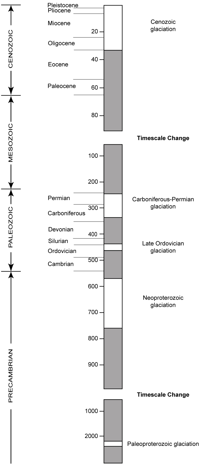 pose an additional problem in their climatic interpretation. Paleogeographic reconstructions based on paleomagnetic data (e.g., Kilner et al., 2005) indicate that part of these deposits were located at tropical latitudes at the time of their formation. This has led some researchers to hypothesize a Neoproterozoic “Snowball Earth” entirely covered with ice (Hoffman et al., 1998; Bodiselitsch et al., 2005), a scenario which is not completely accepted by other researchers (McCall, 2006; Allen & Etienne, 2008).
Implications for creationist models
Although at least some of the evidence for past glaciations could be explained by invoking alternative processes, Precambrian ice ages (i.e., the Paleoproterozoic and Neoproterozoic ice ages, Fig. 1) are potentially not in conflict with creationist views of Earth history. It is possible that before the creation of life the planet was at least partially covered by ice. Similar conditions are observed on Mars, a planet of the solar systems with polar ice caps (Picardi et al., 2005). On the other hand, deposits attributed to the Ordovician and Permo-Carboniferous glaciations (Fig. 1) are enclosed within the Paleozoic rock record, where fossil-bearing sediments document coeval existence of many forms of life on Earth. Therefore, these two ice-ages are more difficult to accept in short-chronology creationist models, especially if the Paleozoic rock record is viewed as deposited during the Genesis flood.
The chronology of past ice-ages is also an aspect where creationists differ with geologic models based on radiometric ages of millions or hundreds of thousands of years. Some attempts have been made at framing at least the Cenozoic glaciation in a short-chronology model (Oard, 1990).
Independently of the dating and preferred interpretation of Paleozoic glacigenic-like deposits, both creationist and non-creationist geologists agree that the Mesozoic is a portion of the stratigraphic column with no indications of glacigenic features (Fig. 1) whereas the Cenozoic preserves convincing evidence of glacial activity. This stratigraphic distribution of glacial deposits is consistent with creationist models that associate Mesozoic deposits with the peak of the flood and consider Cenozoic deposits as mostly post-flood. Glacial activity would not be expected in an advanced stage of the flood, whereas a climate deterioration leading to glaciation could be triggered in the recovery phase subsequent to the flood and extending into the present.
The Cenozoic glaciation is thought to have been characterized by cyclic fluctuations that can be globally correlated (e.g., Zachos et al., 2001). These fluctuations between glacial and interglacial conditions have been explained as resulting from variations in orbital parameters of the Earth (e.g., Maslin et al., 1998; Huybers & Wunsch, 2005; Roe, 2006), happening over time scales of 100 ka (eccentricity), 40 ka (obliquity) and 20 ka (precession). These time ranges are problematic from a short-chronology perspective, and creationists have motivation to search for alternative processes that could account for this global cyclical signal within a much shorter time scale.
In conclusion, careful study of modern glacigenic deposits and structures is important for the interpretation of past glacigenic-like deposits. At the same time, creationists approach evidence for glaciation in the geological record with an eye open to explore alternative interpretative hypotheses compatible with short-chronology models of the history of the Earth.
[1] The term “interglacial” is used to indicate a warm period with reduced ice caps between two cold periods with extensive ice cover.
[2] ka = 1,000 years
Ronny Nalin, PhD
Geoscience Research Institute
References
Allen, P.A., Etienne, J.L., 2008. Sedimentary challenge to Snowball Earth. Nature Geoscience, v. 1/12, p. 817-825.
Arnaud, E., Eyles, C.H., 2002. Glacial influence on Neoproterozoic sedimentation: the Smalfjord Formation, northern Norway. Sedimentology, v. 49, p. 765-788.
Bennett, M.R., Doyle, P., Mather, A.E., 1996. Dropstones: their origin and significance. Palaeogeogr. Palaeoclimatol. Palaeoecol., v. 121, p. 331-339.
Bodiselitsch, B., Koeberl, C., Master, S., Reimold, W.U., 2005. Estimating duration and intensity of Neoproterozoic snowball glaciations from Ir anomalies. Science, v. 308, p. 239-242.
CLIPMAP Project Members, 1981. Geol. Soc. Am. Map Ser. MC-36.
Donovan, S.K., Pickerill, R.K., 1997. Dropstones: their origin and significance: a comment. Palaeogeogr. Palaeoclimatol. Palaeoecol., v. 131, p. 175-178.
Eyles, N., Januszczak, N., 2007. Syntectonic subacqueous mass flows of the Neoproterozoic Otavi Group, Namibia: where is the evidence of global glaciation? Basin Research, v. 19, p. 179-198.
Hoffman, P.F., Kaufman, A.J., Halverson, G.P., Schrag, D.P., 1998. A Neoproterozoic snowball Earth. Science, v. 281, p.1342- 1346.
Huybers, P., Wunsch, C., 2005. Obliquity pacing of the late Pleistocene glacial terminations. Nature, v. 434, p. 491-494.
Kilner, B., Mac Niocaill, C., Brasier, M., 2005. Low-latitude glaciation in the Neoproterozoic of Oman. Geology, v. 33/5, p. 413-416.
Lambeck, K., Esat, T.M., Potter, E.-K., 2002. Links between climate and sea levels for the past three million years. Nature, v. 419, p. 199-206.
Maslin, M.A., Li, X.S., Loutre, M.F., Berger, A., 1998. The contribution of orbital forcing to the progressive intensification of northern hemisphere glaciation. Quat. Sci. Rev., v. 17, p. 411-426.
McCall, G.J.H., 2006. The Vendian (Ediacaran) in the geological record: Enigmas in geology’s prelude to the Cambrian explosion. Eart-Sci. Rev., v. 77, p. 1-229.
Oard, M.J., 1990. An Ice Age Caused by The Genesis Flood. Institute for Creation Research, San Diego. 244 pp.
Oard, M.J., 1997. Ancient Ice Ages or Gigantic Submarine Landslides? Creation Research Society, Chino Valley, Arizona. 130 pp.
Peltier, W.R., 1994. Ice age paleotopography. Science, v. 265, p. 195-201.
Picardi G., Plaut, J.J., Biccari, D., Bombaci, O., Calabrese, D., Cartacci, M., Cicchetti, A., Clifford, S.M., Edenhofer, P., Farrell, W.M., Federico, C., Frigeri, A., Gurnett, D.A., Hagfors, T., Heggy, E., Herique, A., Huff, R.L., Ivanov, A.B., Johnson, W.T.K., Jordan, R.L., Kirchner, D.L., Kofman, W., Leuschen, C.J., Nielsen, E., Orosei, R., Pettinelli, E., Phillips, R.J., Plettemeier, D., Safaeinili, A., Seu, R., Stofan, E.R., Vannaroni, G., Watters, T.R., Zampolini, E., 2005. Radar soundings of the subsurface of Mars. Science, v. 310, p. 1925-1928.
Rice, A.H.N., 2004. Glacial influence on Neoproterozoic sedimentation: the Smalfjord Formation, northern Norway – discussion. Sedimentology, v. 51, p. 1419-1422.
Roe, G., 2006. In defense of Milankovitch. Geophys. Res. Lett., v. 33, L24703, doi:10.1029/2006GL027817.
Stokstad, E., 2001. Myriad Ways to Reconstruct Past Climate. Science, v. 292, p. 658-659.
Yokoyama, Y., Lambeck, K., De Deckker, P., Johnston, P., Filfield, L.K., 2000. Timing of the Last Glacial Maximum from observed sea-level minima. Nature, v. 406, p. 713-716.
Zachos, J., Pagani, M., Sloan, L., Thomas, E., Billups, K., 2001. Trends, rhythms, and aberrations in global climate 65 Ma to present. Science, v. 292, p. 686-693.