THE MIOCENE/PLEISTOCENE CONTACT IN THE COLUMBIA BASIN: TIME IMPLICATIONS
by Harold G. Coffin The Dalles, Oregon
INTRODUCTION
Approximately 14 million years is thought to have elapsed between the laying down of the last flow of most of the Columbia River Basalts and the deposition of the wind-blown glacial silts of the Palouse soil (Baksi 1989, Fryxell and Cook 1964). If 14 million years were involved, the amount of erosion should be profound, cutting down into many basalt beds of the Columbia River Plateau. The purpose of this research was to examine this contact for evidence of 14 million years of erosion.
Many so-called time gaps exist in the geologic record. Some of these time gaps show little erosion, even though many millions of years are said to have elapsed between the laying down of the lower bed and the deposition of the upper stratum. Roth (1988) has commented on the significance of this phenomenon. The geology in this part of Eastern Washington State seemed suitable for a close examination of one of these gaps, even though the time gap is not as great as has been seen at some other locations. The gap exists between the uppermost deposit of Miocene Columbia River Basalt and the Pleistocene Palouse loess that overlies it. The bed below the gap was laid down as molten lava. If no long period of gradual deposition was involved, the contact should be sharp, unless eroded. Another factor favoring this study was the great difference between the two beds — one being hard, dark volcanic material and the other being light, soft loess of sedimentary origin.
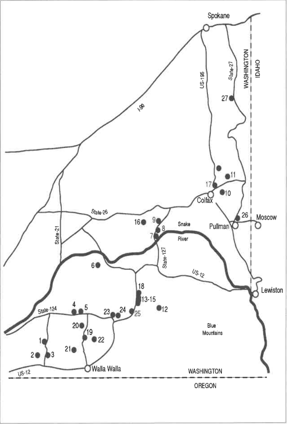
FIGURE 1. A map of the Palouse county of Southeastern Washington. The collection sites are numbered according to the chronological order in which they were discovered and examined during three separate trips to the area.
LOCATION AND GEOLOGY
The area studied is a plateau that lies in Washington State between Walla Walla on the south and Spokane on the north, and between the Idaho border on the east and U.S. Highway 395 on the west (Figure 1).
The topography of most of this area is rolling hills that are the result of the warping and doming of the basalt, and several canyons that cut deep into the plateau. The elevation gradually drops from about 850 m on the east to around 150 m on the west. Several topographic highs on the east side are composed of the Precambrian granites that underlie the basalt. The best-known of these are Steptoe Butte (front cover photo) and Kamiak Butte, 1101 m and 1110 m high respectively.
Mantled over the basalt (but not on the steep granite buttes) is a thick layer of fine sediment considered to be wind-blown glacial silt (Busacca 2001). The silt feathers out toward the north and west and disappears among the forested foothills of the Rocky Mountains of Idaho. Except along the edges, it provides an excellent soil up to 5 m deep that is utilized for both dry wheat farming and irrigated crops.
The Missoula Flood (sometimes called the Bretz Flood, or the Spokane Flood) that resulted from the breaking of an ice dam that produced huge Lake Missoula in the intermountain valleys of Northern Idaho and Western Montana removed the loess from long northeastsouthwest trending tracts and scoured out deep canyons in the underlying basalt (Orr, Orr and Baldwin 1992).
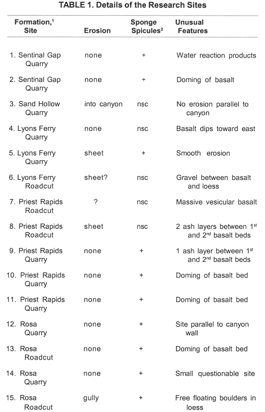
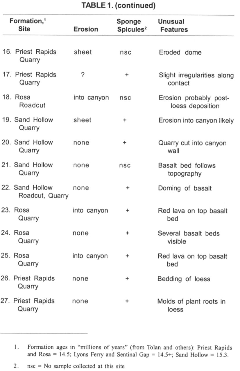
Many flows of lava (over 300) that arose from fissure eruptions in Southeastern Washington, Northeastern Oregon and adjacent Idaho were laid down in the Columbia Basin before the deposition of the loess (Tolan et al. 1989). These eruptions are interpreted to have commenced around 17 million years ago. Nine-tenths or more of the total lava had been ejected by 14 million years (Tolan et al. 1989). Three major suites of basalt, the Saddle Mountains, Wanapum, and Grande Ronde (Reidel 1983) make up the basalt beds of the research area. The uppermost basalt bed at all the 27 sites examined and sampled was within the Wanapum basalt group. (See Table 1 for details for each site.) All site samples are located in basalt that has been radiometrically dated at 15.3 to 14.5 million years old.
METHODS
In this research area, 27 satisfactory exposures of the Miocene/ Pleistocene contact in road cuts and quarries were located during searches along approximately 2400 km of highways and country roads.
The following criteria were established for each site:
The basalt/loess contact must be clearly visible for at least 50 m.
The location must not have been affected by Missoula Flooding erosion.
The sites should not be in or affected by modern canyon cutting and stream erosion.
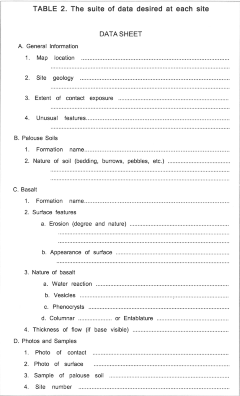
Table 2 illustrates the data sought for each site. Twenty-two loess samples were collected. Loess was not collected at several sites for two reasons. A deep irrigation ditch prevented close access to one site. The loess of several sites with high vertical cliffs could not be reached either from the bottom or the top. When collected, the sample was taken from just above the contact, not from the ground surface at the top of the cliff.
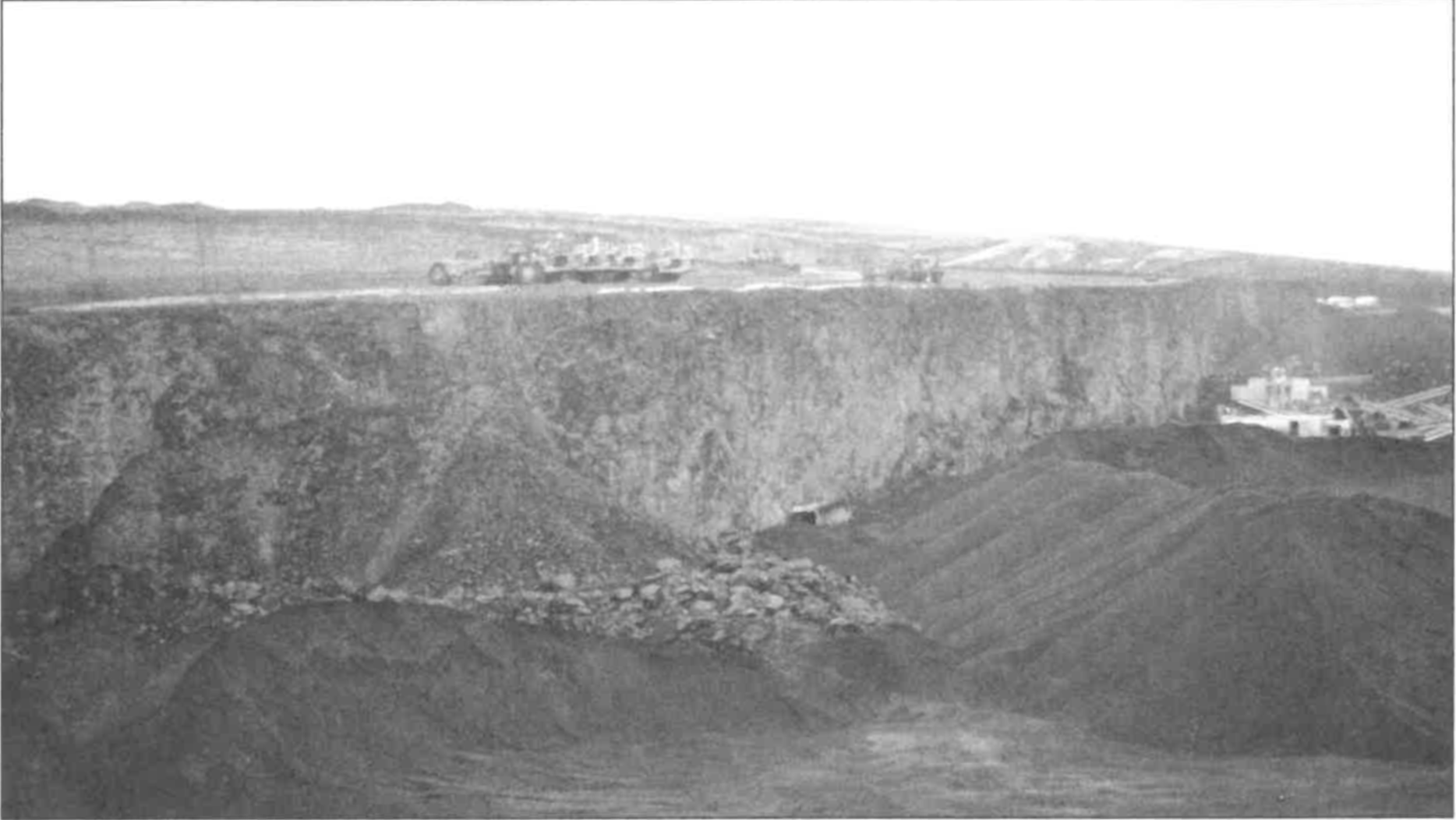
It was originally planned that where possible the surface of the basalt would be excavated for examination. In most cases this was impossible because seldom was the loess above the basalt less than 2 m deep. The amount of excavation to reach the surface of the basalt was impractical. At Site 1 an erosional gully in the loess reached almost to the basalt. Excavation to the basalt surface was achieved. Bulldozing activity or natural erosion at several quarries had removed most of the overlying loess without much disturbance of the underlying basalt. These locations gave opportunity to examine the basalt surface (Figure 2).
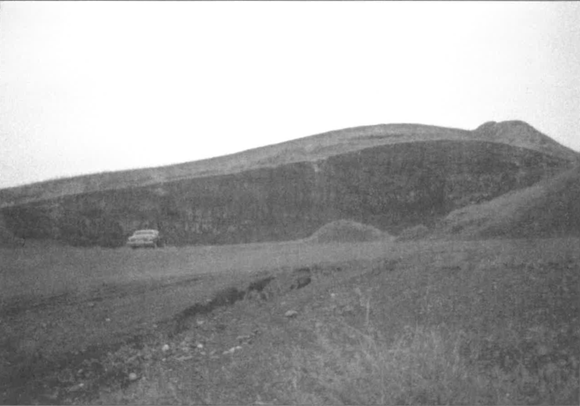
FIGURE 2. At Site 26, the equipment is sitting on the smooth, flat surface of the basalt. The loess, visible in the background, has been removed.
Every effort was made to avoid the modern erosion coulees and canyons or those produced by the Missoula Floods, but some quarries had been cut back into the hillside from a stream or river canyon. In such cases it was difficult to determine if the quarry face that ran parallel to the canyon had pushed past the erosion crest of the canyon wall. With one exception, all gully erosion seen at the sites was associated with erosion that was post-loess deposition. The one exception was a road cut in U.S. 12, about 11 km north of Dayton, Washington. The road cut was high on a deep canyon wall, and there was a question as to whether it met the criteria of a suitable site. It had some unique features that will be discussed later.
RESULTS
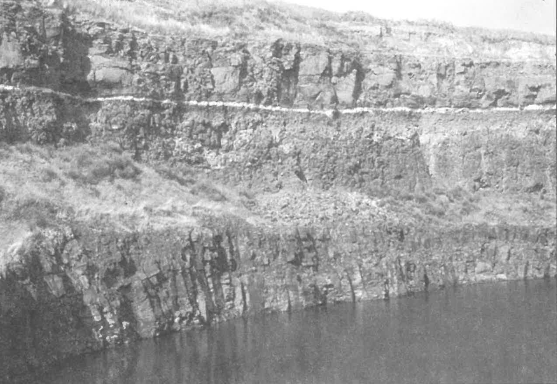
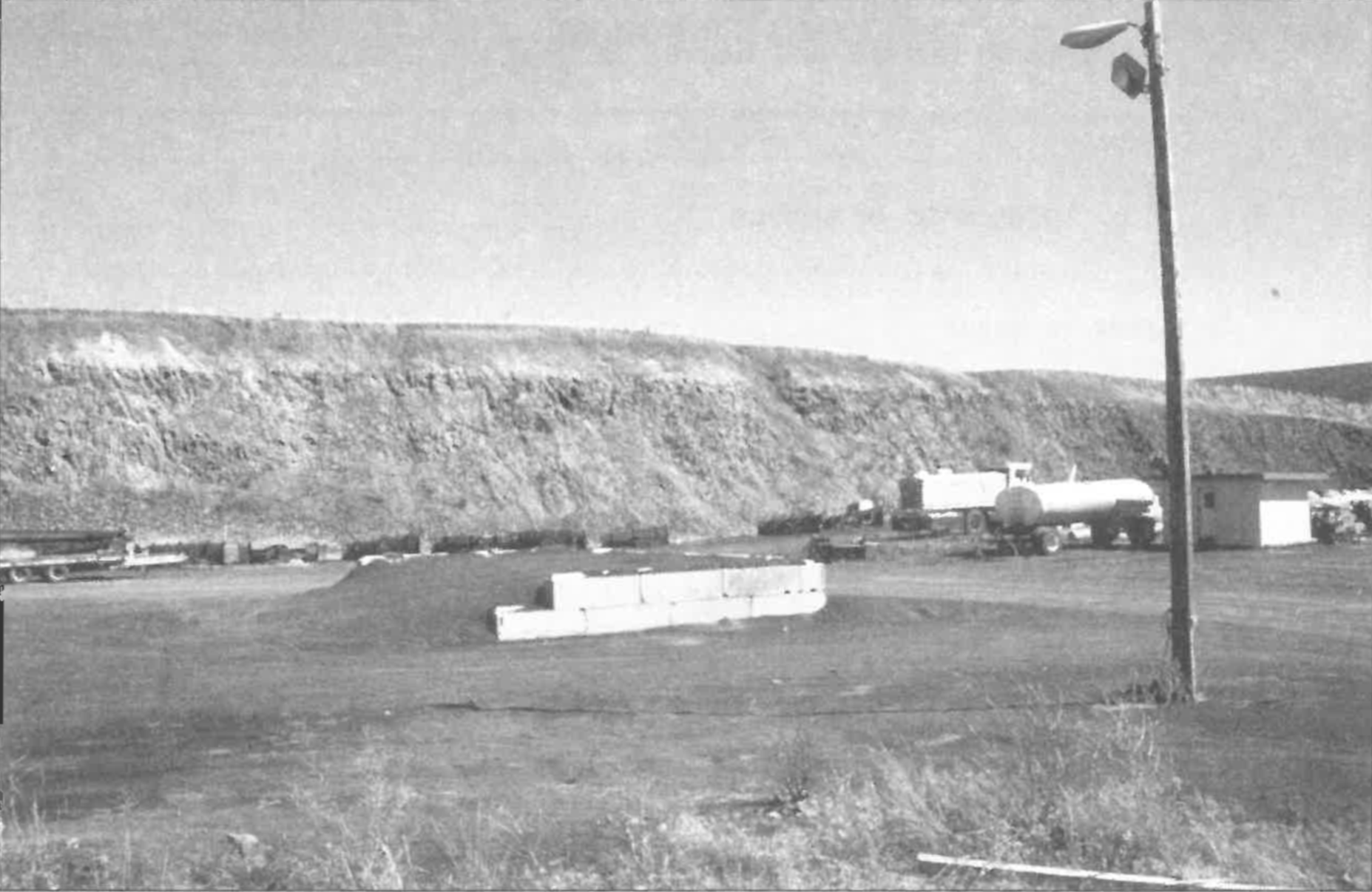
Fifteen of the 27 sites had sharp contacts exhibiting no or slight erosion (Figures 2-4 illustrate three such sites).
FIGURE 3. Aquarry (Site 9) showing two beds of basalt and overlying loess. A thin band of gray volcanic ash lies between the top and second beds of basalt.
FIGURE 4. This large active quarry (Site 17) clearly shows the sharp unbroken contact line between basalt and loess.
In general, the sharp, straight contact between the basalt and the loess was striking. However, the exposed surfaces of the basalts, where visible, did not have a knife edge of intact basalt, but the surfaces were blanketed with a thin layer of loose, angular basalt rocks usually less than fist size (Figure 5).
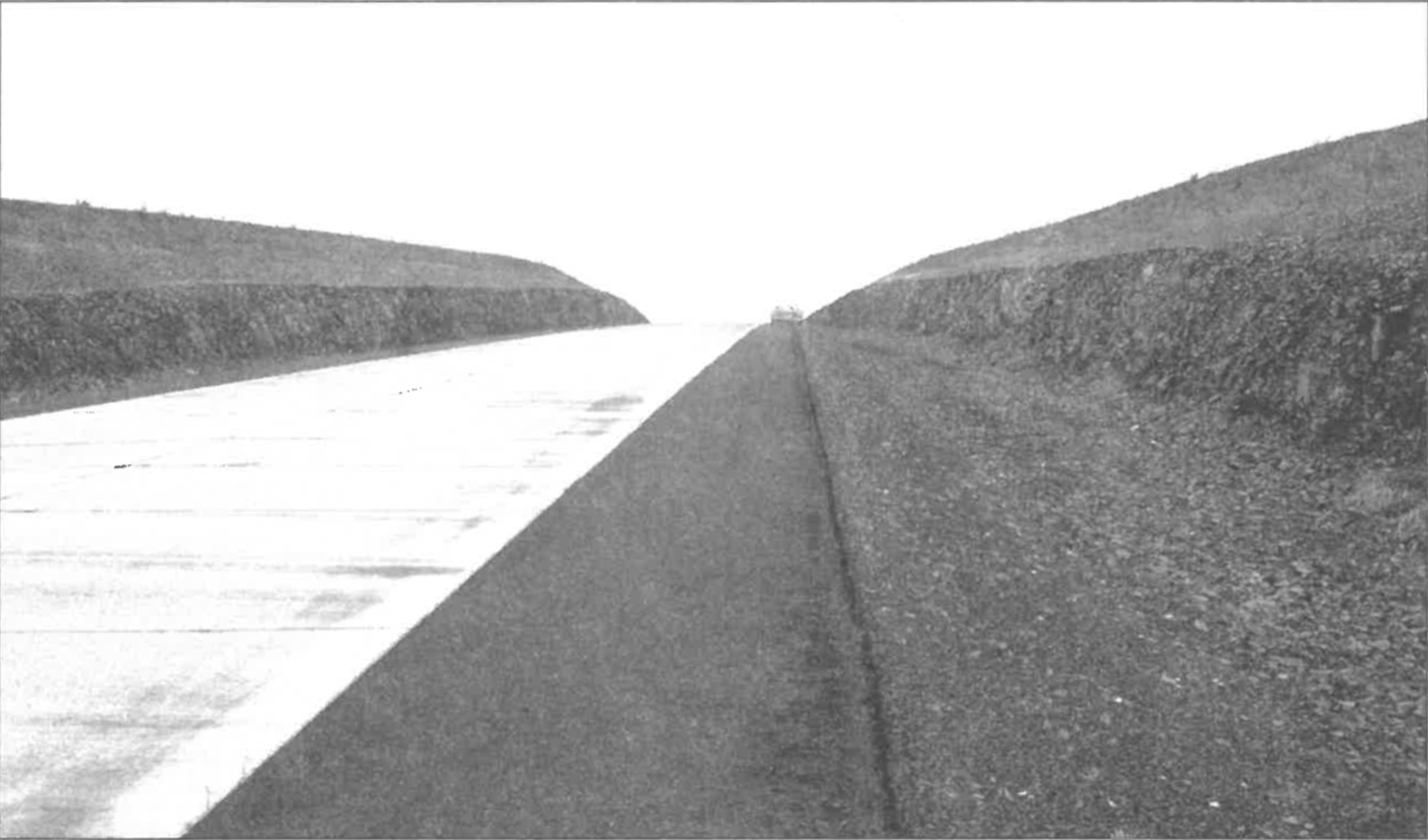
FIGURE 5. A long road cut showing the smooth contact between the basalt and the overlying loess. There was 10-20 cm of gravel between the top of the basalt bed and the loess.
Five, perhaps six, sites displayed sheet erosion. This could be determined in two ways. First, where the bottom of the top basalt bed was visible, thinning by erosion could be seen by tracing horizontally along the bed. In some cases, the bed, as seen in cross section in an anticlinal dome, gradually and smoothly feathered laterally on both sides of the anticline, and sometimes the erosion continued cutting down into the lower beds (Figure 6). Second, in cases where the bottom of the top basalt bed was not visible, one could assume that if basalt columns were not at right angles to the top surface of the bed, erosion was the cause, rather than bending or warping of the flow.
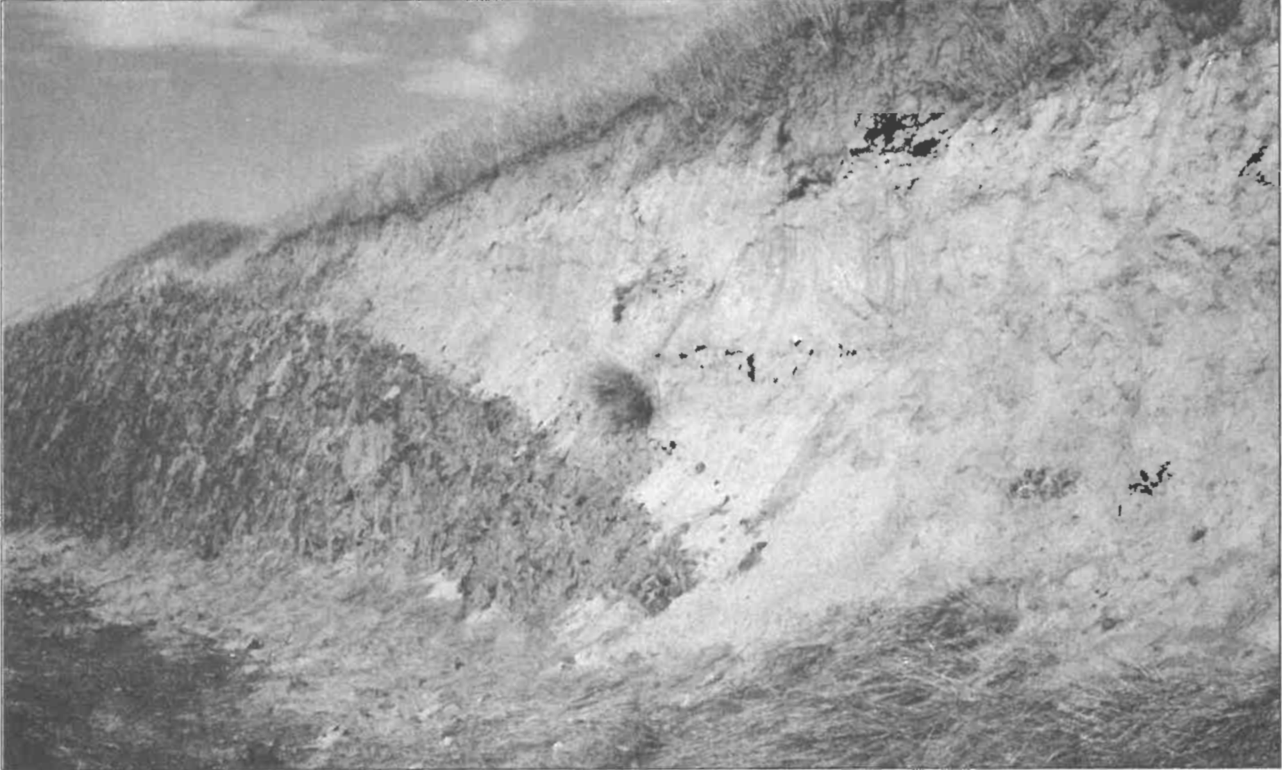
FIGURE 6. Site 5. Sheet erosion that appears to cut down through several basalt beds.
Ten sites showed either doming of the basalt, or dipping of the surface. The modern loess topography often matched the doming or slope of the underlying basalt.
Talus from the Pleistocene Missoula Flood erosion and modern erosion and weathering is clearly visible in many areas. No examples of large beds of pre-Pleistocene erosional deposits were seen in the research area. There are, however, large deposits of such material outside the research area. (The Dalles Formation in north central Oregon, the Eagle Creek Formation in the northern Cascade Mountains, and the Ellensburg Formation in south central Washington are massive deposits of conglomerates and breccias. Some of them contain exotic pebbles and boulders from outside the Columbia River Basalt Plateau mixed with volcanic rocks eroded from the Plateau.)
As indicated in Table 1, all samples of loess collected showed broken sponge spicules. The source of the spicules is not known, but they are derived from marine sponges.
Normally the loess is homogenous, but closer examination does show some minor bedding. Occasionally, fist-sized or larger rocks are found free-floating in the loess (Figure 7).
FIGURE 7. Site 15. Gully erosion of basalt along the edge of a deep canyon. Pebbles and rocks are free-floating in the loess above the basalt.
DISCUSSION
The three issues of greatest interest for this study are the relative lack of gully erosion in the basalt, the cause of the sheet erosion and the origin of the sponge spicules. The questions raised by these observations can be better understood by referring to the following sequence of geological events in the research area:
Emplacement of the granite.
Erosion of the granite into knobs and hills as seen along the northern edge of the Columbia River Basalt Plateau and in the steptoes protruding above the basalt.
Eruption of lava and the laying down of numerous beds of basalt all the way to the Pacific Ocean off the Oregon and Washington coasts.
Occasional thin beds of sediment and minor erosion between basalt beds (Items 3 and 4 would have been contemporaneous).
Warping and doming of basalt beds.
Sheet erosion on a minor scale (Items 5 and 6 may have been contemporaneous).
The laying down of the Palouse loess with fair abundance of sponge spicules.
Major erosion from the Missoula Floods.
Minor erosion and slumping of Palouse loess due to weathering and modern agricultural activities.
Note that the sheet erosion (Item 6) occurred before the laying down of the loess (Item 7).
Considering the length of time normally calculated to have passed between the laying down of the last basalt bed and the depositing of the loess, erosion should have been profound. Although some erosion exists, it is infinitesimal compared to what should be seen. The uneroded surface of the uppermost bed below the loess appears to repeat what we see in the underlying beds as revealed in the walls of the deeper canyons of the area. In the area of Palouse Falls, which is located in the major Cheney-Palouse erosion tract of the Missoula Floods, several valleys were stripped of the overlying loess, but with little or no erosion of the underlying basalt.
Modern small streams, such as seen in the region today, cut V-shaped channels into the basalt, or if large enough, U-shaped channels with vertical walls. The Pleistocene Missoula Flood cut major canyons. What is the explanation for the sheet erosion? The absence of gully erosion superimposed on the sheet erosion suggests that the sheet erosion was not the result of prolonged weathering. Talus slopes or piles of rock debris resulting from pre-Missoula Flood erosion were not seen in the research area. Apparently these sediments were transported elsewhere. Thus the cause and time of the sheet erosion, though insignificant compared to the erosion expected in 14 million years, remains a question for further research.
The presence of sponge spicules in the loess throughout the research area is an enigma (Table 1). Although freshwater sponges are known, the abundance of the observed spicules and their siliceous composition indicates their sources to have been marine sponges. It seems difficult to postulate a marine origin for the loess. To my knowledge, no marine sediments adjacent to the Columbia River Basalts are likely sources for these organic remains.
CONCLUSION
Examination of the contact between the Miocene Columbia River Basalt and the Pleistocene Palouse loess revealed no gully erosion except for Missoula Flood and modern erosion, both of which were excluded from the study. A thin layer of what appears to be a weathering profile mantles the top of the last basalt flow. Pre-Missoula Flood erosion consisted of a minor amount of smooth, broad sheet erosion, the cause of which has yet to be determined. A lapse of 14 million years between the last lava flow and the deposition of the loess is not supported by the data from this research.
ACKNOWLEDGMENT
I wish to thank the Geoscience Research Institute for their encouragement and for a grant to cover expenses involved in the research. I also thank Dennis Bokovoy and John Hergenrather who accompanied me on one trip to the plateau and contributed valuable comments.
LITERATURE CITED
Baksi AK. 1989. Reevaluation of the timing and duration of extrusion of the Imnaha, Picture Gorge, and Grande Rounde Basalts, Columbia River Basalt Group. Geological Society of America Special Paper 239:105-111.
Busacca AJ. 1991. Loess deposits and soils of the Palouse and vicinity. In: Morrison RB, editor. Quaternary Nonglacial Geology: Conterminous united States. Geological Society of America, Geology of North America K-2:216-228.
Fryxell R, Cook EF. 1964. A field guide to the loess deposits and channeled scablands of the Palouse area, Eastern Washington. Laboratory of Anthropology, Washington State University, Pullman, Washington. Report of Investigations No. 27.
Orr EL, Orr WN, Baldwin EM. 1992. Geology of Oregon. 4th edition. Dubuque, IA: Kendall/Hunt Publishing Company, p 26-27.
Reidel SP. 1983. Stratigraphy and petrogenesis of the Grande Ronde Basalt from the deep canyon country of Washington, Oregon, and Idaho. Geological Society of America Bulletin 94:519-542.
Roth AA. 1988. Those gaps in the sedimentary layers. Origins 15:75-92.
Tolan TL, Reidel SP, Beeson MH, Anderson, JL, Fecht, KR, Swanson, DA. 1989. Revisions to the estimates of the areal extent and volume of the Columbia River Basalt Group. Geological Society of America Special Paper 239:1-20.