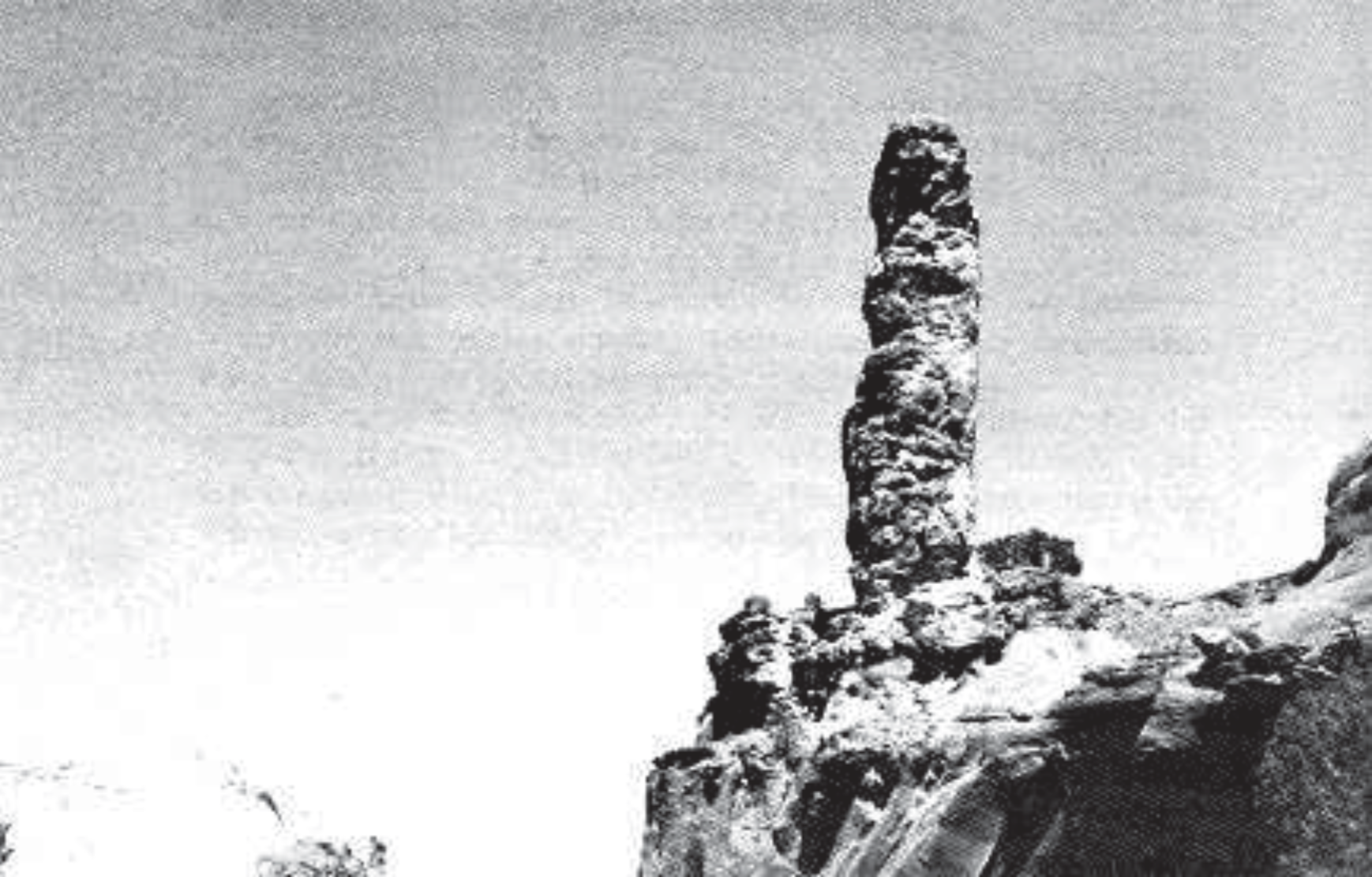
In the region of the Kodachrome Basin State Park, Utah, are found some unusual vertically oriented, intrusive sedimentary structures. They are called pipes if cylindrical in shape (see Figure 1 and cover photo), or dikes if flat-like in shape. These structures, which sometimes reach heights well over 50 m (150'), have come from the sedimentary layers below. In the same area, there is also indication of collapse of some sediments into lower layers (Christiansen 1952).
FIGURE 1. One of the largest exposed "pipes" in Kodachrome Basin. The surrounding rock, which is softer, has been eroded away, leaving this 50 m (150') "monolith." The surface of the pipe is badly eroded.
These features in the Jurassic layers raise interesting questions regarding the amount of time involved in their formation. The source layers would have to be soft in order to intrude into other layers. Sediments cannot remain soft forever; they tend to become cemented. Cementation occurs when dissolved minerals are carried by water into the sediments, hardening them into rocks. Some other features of these pipes also suggest that there was not much time between deposition of these layers and recent (Plio-Pleistocene) geologic activity. The conundrum is that the standard geologic time scale implies well over 150 million years between laying down of these sediments and what appears to be the time of intrusion.
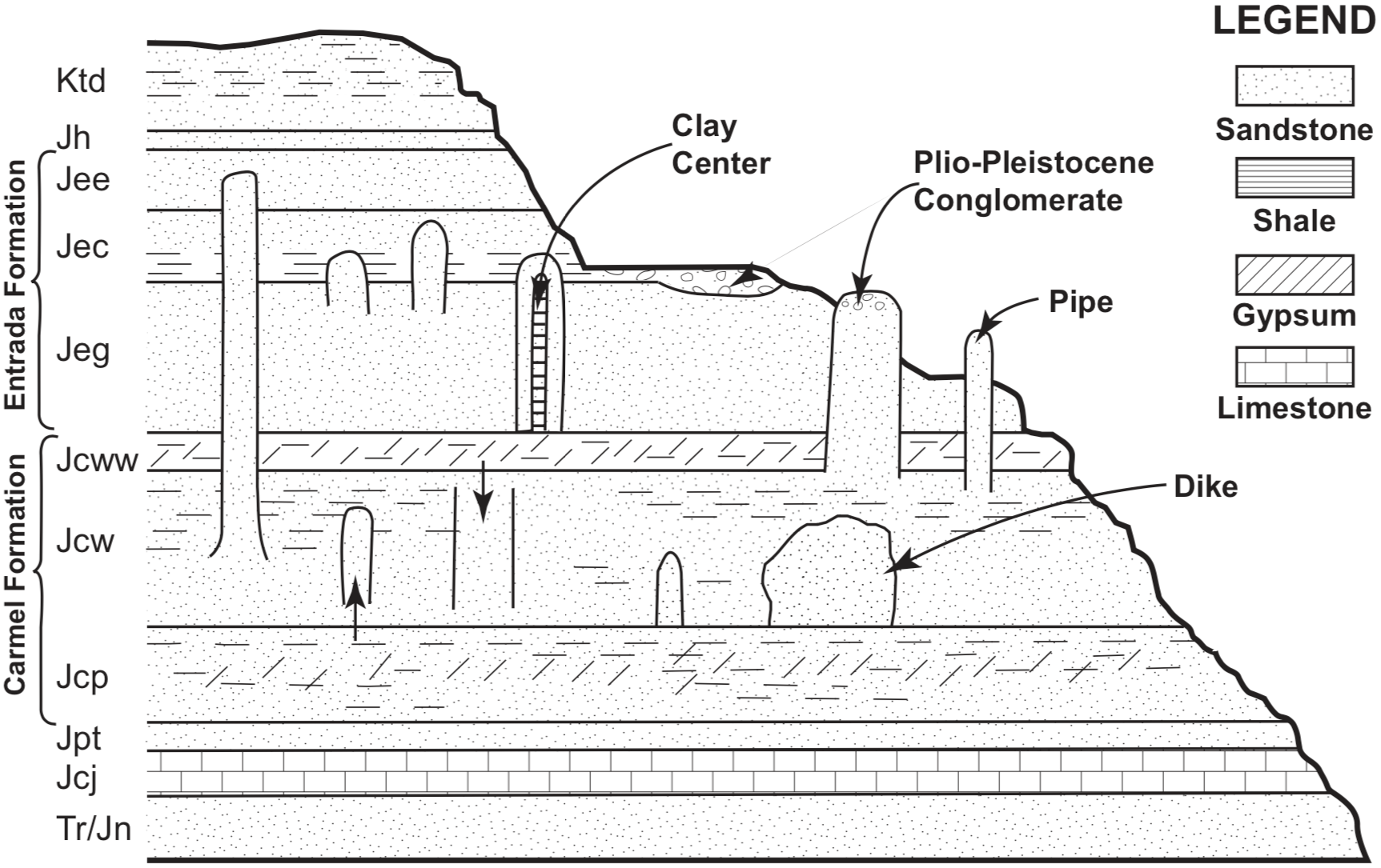
The details of these strata, which are about 600 m (2000') thick, have been worked out by Thompson and Stokes (1970) (see Figure 2). The Jurassic layers involved have a putative age of 144-208 million years. The Carmel Formation of this group averages around 179 million years, and the Entrada averages around 166 million years. In parts of the area an unnamed Plio-Pleistocene channel and sheet conglomerate (Gregory 1951) covers various formations. It contains basalt pebbles considered to be only 1-6 million years old, and therefore is interpreted to be much younger than the main Jurassic sedimentary formations of the area.
FIGURE 2. Diagrammatic representation of a section through the pipe and dike-bearing strata in Kodachrome Basin. Legend for formations: Tr/Jn Triassic-Jurassic Navajo; Jcj Jurassic Carmel, Judd Hollow; Jpt Jurassic Page Sandstone, Thousand Pockets Tongue; Jcp Jurassic Carmel, Parla River Member; Jcw Jurassic Carmel, Winsor Member; Jcww Jurassic Carmel, Wiggler Wash Member; Jeg Jurassic Entrada, Gunsight Butte Member; Jec Jurassic Entrada, Cannonville Member; Jee Jurassic Entrada, Escalante Member; Jh Jurassic Henrieville Formation; Kdt Cretaceous Dakota-Tropic Formations undifferentiated.
Hornbacher (1984) has mapped and described 67 pipes and many dikes in the area. They are found at various stratigraphic levels, but dominate in the Gunsight Butte member of the Entrada (Figure 2). One intrudes as far up as the Escalante member of the Entrada. The pipes range up to 52 m (170') in exposed height and up to 15 m (50') in diameter. Analysis of the rocks and minerals in the pipes shows similarity, mainly to the upper Paria River and lower Winsor Formations below. They are the most likely source for most of the pipes. Some upper Winsor and Thousand Pockets Tongue of the Page Sandstone (see Figure 2) and possibly other layers have occasionally also served as source for the pipes.
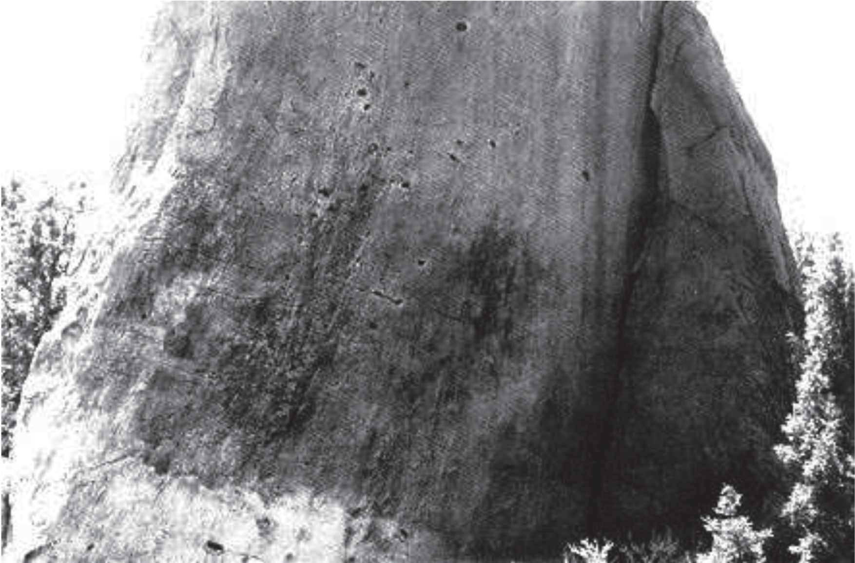
The mechanism for intrusion is problematic and may never be known. Hannum (1980) has suggested that the pipes came from cold springs. Hornbacher (1984) favors seismically induced sediment liquefaction and intrusion. The relatively smooth and striated wall pattern of some pipes (Figure 3) favors the latter interpretation. To add to the mystery, there seems to be little or no disturbance of bedding planes or indication of compressive strain in the sediments surrounding the pipes. This suggests that both the pipe material and the surrounding sediments were soft when the pipes formed.
FIGURE 3. Closeup view of the surface of one of the pipes showing vertically oriented striations. The slightly darker vertical rock wedge to the right is not part of the pipe but a remnant of the surrounding "rock" into which the pipe intruded.
Hornbacher (1984) gives evidence that intrusion took place at the time of the recent Plio-Pleistocene conglomerate deposition. This includes: 1) intimate association of the Plio-Pleistocene conglomerate with the top of one pipe; 2) fluid escape structures from this pipe into the conglomerate; and 3) the Plio-Pleistocene tectonic activities in the region (i.e., earthquakes, orogenies) needed for the suggested mechanism of intrusion. LeFevre et al. (1987) suggest a Jurassic age for formation of the pipes, but give no direct supportive evidence.
These pipes appear to present a problem for the standard geologic time scale, since it would require that the Jurassic formations which serve as source for the intrusions remain soft (uncemented by minerals) for over 150 million years. Considering how easily cementing minerals are transported through sediments by water, this seems highly unlikely. It also seems highly unlikely that a delithification process (dissolving of cement) would take place at the same time throughout the thick and highly varied sequence over the widespread area in which these pipes are found.
Even if one does not take into consideration the evidence for a Plio-Pleistocene intrusion, there is still a problem for the standard geologic time scale. The time, represented by the vertical distance between the source of the pipes and their present location, would be many millions of years (13 million if you use the average Carmel and Entrada ages). It seems very unlikely that the source material could remain uncemented for that length of time. Some of the pipes intrude 100 m (300') of sediment.
One can argue that since there are now soft sediments on the ocean floor which are assumed to be many millions of years old, the sediments producing the pipes and the surrounding rocks could have likewise remained soft for many millions of years. However, the situation associated with these pipes does not appear to be comparable. Some of the layers associated with the pipes are interpreted as being terrestrial instead of marine. We do not now see in the continental crust older layers in a fluid state that could form the pipes. Associated with these pipes and dikes are long fine veins originating from the pipes and penetrating the surrounding layers. These seem to mandate a highly fluid source (i.e., the pipes themselves). However, it seems virtually impossible for the intruding material in these veins to have remained soft for any extended period of time. An overburden of more than 1200 m (4000') of sediment once covered the now-exposed area where these pipes are found. This overburden would create a pressure of 275×105 Pascals (4000 lb/in2). Such pressure would induce rapid cementation, precluding a Plio-Pleistocene intrusion.
These pipes are fascinating structures. The model of formation that seems to best fit the data would be rapid deposition during the recent Genesis flood, with subsequent seismic activity liquefying uncemented sediments which would then intrude into the overlying soft sediments, forming the pipes and dikes.
REFERENCES
Christiansen, F. W. 1952. Slump structures and associated "clastic intrusions" in Upper Jurassic sediments, Kane and Garfield Counties, Utah. Geological Society of America Bulletin 63:1359.
Gregory, H. E. 1951. Geology and geography of the Paunsaugunt region, Utah. U.S. Geological Survey Professional Paper 164.
Hannum, C. 1980. Sandstone and conglomerate breccia pipes and dikes of Kodachrome Basin area, Kane County, Utah. Brigham Young University Geology Studies 27:31-50.
Hornbacher, D. 1984. Geology and structure of Kodachrome Basin State Reserve and vicinity, Kane and Garfield Counties, Utah. M.A. Thesis. Loma Linda University.
LeFevre, L. M., G. L. Pollock, and C. F. Lohrengel II. 1987. Geology of Kodachrome Basin State Park. Encyclia. 64:114-120.
Thompson, A. E. and W. L. Stokes. 1970. Stratigraphy of the San Rafael Group, southwest and south central Utah. Utah Geological and Mineralogical Survey Bulletin 87.
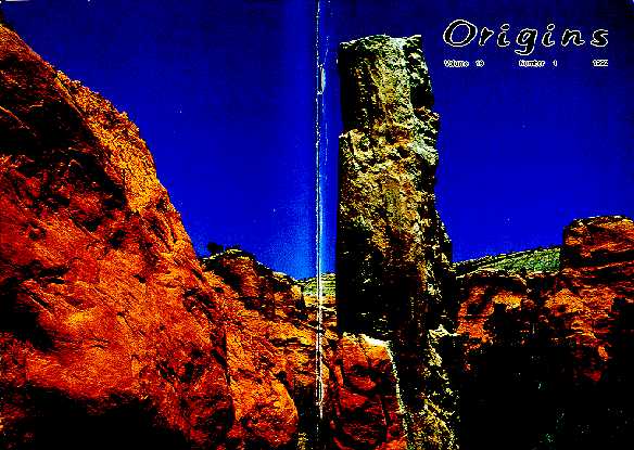
COVER. View of a clastic "pipe" in Kodachrome Basin State Park in southwestern Utah, U.S.A. The origin of these pipes has been an enigma. For further discussion, see the General Science Note in this issue. Photo taken by Ariel A. Roth.