©Copyright 2018 GEOSCIENCE RESEARCH INSTITUTE
11060 Campus Street • Loma Linda, California 92350 • 909-558-4548
Translated and revised edition (approved by the author) of Kotulla, Michael (2018): Rasche Entstehung der Wutachschlucht? Studium Integrale Journal 25 (1), 4-11.
English version incorporates text originally included in footnotes of supplementary files.
Abstract
Up to 160 m deep, 1 km wide and about 30 km long: in Germany the Wutach Gorge is called the "Grand Canyon of the Black Forest." The formation of the Wutach Gorge is not historically documented; it must be reconstructed by geological considerations and evidence. Conventional geological models assume that the Wutach Gorge formed at the end of the Ice Age over a period of thousands of years – triggered by a river deviation and followed by gradual deepening. The Wutach Gorge has become widely known as a textbook example of stream capture. However, it is possible that the landscape-altering process of carving this large gorge could have been caused by catastrophic events, rather than occurring gradually. This scenario requires erosive power that can only be achieved by water flows with discharge magnitudes of at least 10³ to 104 m³/s. Since the formation of the Wutach Gorge is directly related to the melting of the Feldberg Glacier, availability and discharge of high volumes of water is plausible. It is assumed that a catastrophic initial event – the sudden release of large amounts of meltwater – led to an abrupt large flood and overflow of the paleo Feldberg-Danube (Danube catchment), and this resulted in the immediate connection to the lower lying valley of the paleo Wutach River (Rhine catchment). Possibly, large volumes of meltwater were released suddenly, several times. The deepening of the gorge may have lasted only weeks. This scenario, including empirical data on the formation of small-scale gorges and canyons, clearly deviates from the conventional idea of a gradual deepening over a period of 6,000 to 10,000 years.
Keywords: Stream capture, river avulsion, gradual processes, catastrophic events, large flood
1. Introduction
1.1 Wutach Gorge and Wutach River
The Wutach Gorge is considered a first class example of natural geological features (Fig. 1). It is presented as a textbook model of river deviation, and represents a historical landmark of the struggle fought out between the Danube and the Rhine rivers for the "main European watershed" (Liehl 1988, p. 1). As such, the Wutach Gorge has had a steady place in German and international physical science textbooks for decades, primarily in geomorphology, but also in secondary level school textbooks.
The geologist Hans Cloos (1885-1951) contributed significantly to the fame of the Wutach Gorge. In his widely read book, Conversation with the Earth (1947, 1953), translated in several languages, a chapter is dedicated to the Wutach Gorge. This book, in turn, led to Hans Cloos’ world-wide recognition as one of the most famous structural geologists of his time (Plug 2020). He is one of two German geologists to have won the Penrose Medal of the Geological Society of America.
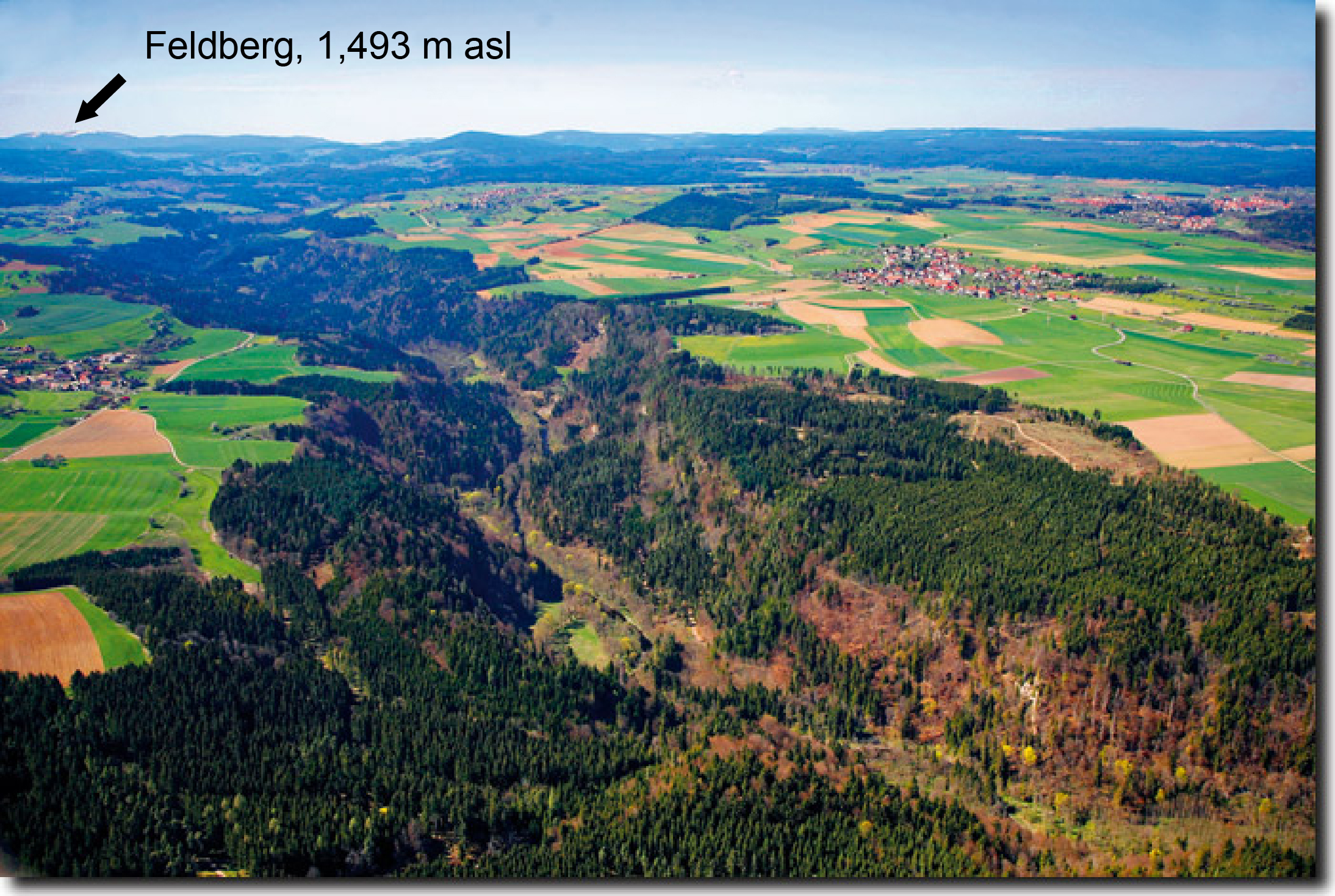
Figure 2: Aerial picture of the Wutach Gorge looking northwest. The villages on the sides of the gorge are Boll (left) and Reiselfingen (right); in the background are the highlands of the Black Forest. Photo credit: Achim Mende (best-of-bodensee-de).
The gorge opens a unique, three-dimensional window into the rock formations found in southwestern Germany. These formations are, from west to east, the crystalline basement and its cover, with the sedimentary sequence of Buntsandstein, Muschelkalk and Keuper – the three constituents of the German Triassic – followed by the Lias and Dogger, both Jurassic.
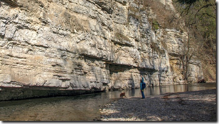
Every year, some 60,000 to 80,000 nature enthusiasts visit the Wutach Gorge and its charming side valleys, enjoying the untouched nature between rushing waterfalls and flowering vegetation at the foot of high, steep valley slopes and mighty rock faces, along a wild river, with a touch of adventure and without a cell phone network (Figs. 1 and 2).
The landscape and catchment area of the Wutach River reaches from the heights of the Black Forest (Fig. 2) to the Swabian Alb (Bauer & Einsele 1993, p. 1). The river originates on the eastern slope of the Feldberg, at ⁓1,440 m asl, and maintains a west-east orientation, but bends towards the south at Achdorf (535 m asl), forming a feature called Wutach Bend (Fig. 3c). Here ends the approximately 23 km-long principal section of the gorge, but a secondary section of the gorge continues south for about 6 km. Finally, maintaining a N/NE to S/SE orientation, the Wutach River flows into the Rhine at Waldshut (330 m asl) (Fig. 4b), for a total length of 91 km.
1.2 Paleo Feldberg-Danube and paleo Wutach River
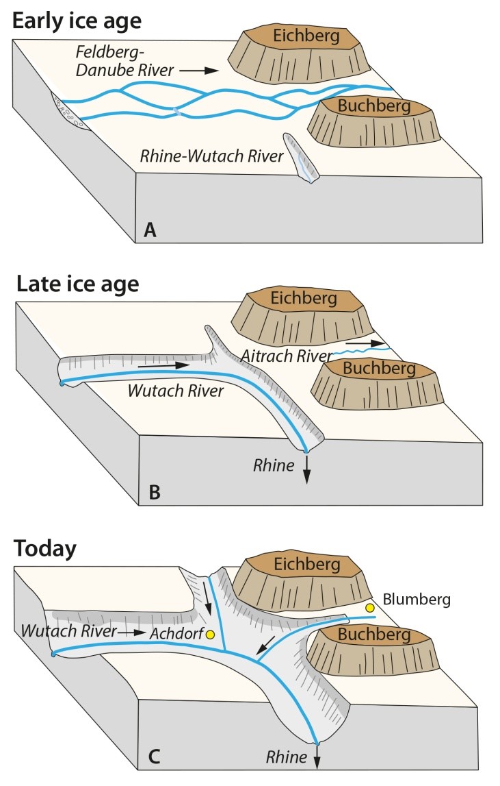
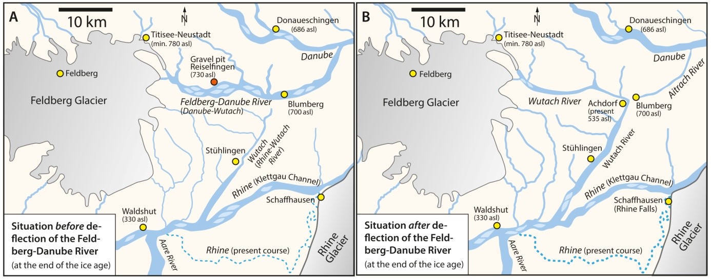
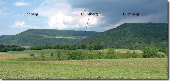
At the termination of the last glacial stage, the Danube had an important headwater in the eastern Feldberg area, the Feldberg-Danube also called Danube-Wutach (Fig. 4a). The Feldberg-Danube valley, up to 2 km wide, extended eastward, across Blumberg Gate (700 m asl) between Eichberg and Buchberg (Fig. 3a and Fig. 5), to the main valley of the Danube. This former connection is documented by gravel deposits in the Aitrach relict valley near Blumberg (Fig. 3c) that are similar to others located more to the east (e.g., gravel pit at Reiselfingen, 730 m asl, Fig. 4a).
South of the Feldberg-Danube, and at a lower elevation by more than 350 m, the Rhine-Wutach tributary flowed to the southwest into the Rhine (Figs. 3a, 4a). It is unclear how close the headwaters of the Rhine-Wutach were to the course of the Feldberg-Danube.
With deviation of the upper course of the Feldberg-Danube and its connection to the Rhine-Wutach – or to its network of headwater streams – a new valley configuration for the Rhine-Wutach was created. As a result, the Danube lost one of its tributaries and no longer receives water from the Feldberg region. In addition, the lower course of the Feldberg-Danube ran dry, leaving today's Aitrach relict valley. This avulsion caused a shift of the Rhine-Danube watershed, increasing the catchment area of the Rhine by about 200 km².
2. Avulsion – mechanisms and timing
2.1 Stream capture and headwater erosion
It is widely argued that stream capture was the mechanism which formed the Wutach Gorge (among others Bauer & Einsele 1993, p.1; Günther 2010, p. 120; Zepp 2014, p. 330; Ahnert 2015, p. 232; Hebestreit, 2016). According to Thome (1998, p. 118), as well as Ahnert (2015, p. 232), capture of the Feldberg-Danube was caused by headwater erosion. The Rhine-Wutach deepened and thereby extended its course backwards to the northeast. Through further backward shifting, the upper valley of the Rhine-Wutach finally reached the valley of the Feldberg-Danube and tapped it. At the tapping point, the striking Wutach Bend formed as a result of the deviation. The valley of the Feldberg-Danube beyond the bend was cut off, and thus beheaded. Today, the Aitrach east of Blumberg flows as a beheaded stream.
Hebestreit (2016, p. 116) also mentions headward erosion occurring from the south (Rhine-Wutach) as the mechanism destabilizing the shallow watershed immediately south of the Feldberg-Danube, until it was finally breached. In terms of actual triggering event, Hebestreit (2016) suspects a combination of “raising of the valley floor of the Feldberg-Danube by deposition of alluvial gravels” and “degradation of the watershed by erosion from the south.” The valley of the Rhine-Wutach farther to the north had already been formed before the avulsion event.
The mechanism of fluviatile headward erosion can only be effective if active runoff occurs, regardless of other boundary conditions. Theoretically, runoff erosion can take place at any point between the initial point of runoff – head of the valley, headwaters– and its end, but not beyond this point. (cf. Busche et al. 2005, figures 270-273; Nalin & Kotulla 2018, figure 10). Heavy rain events are conceivable, which could have initiated numerous, maybe small-scale runoff events and/or higher, new springs above the primary spring of the Rhine-Wutach; however, this is not suggested by any of the authors. Then, it can be assumed that, in the area of the former watershed, not enough water was available for headwater erosion (cf. Metz & Sauer 2012, p. 27). Consequently, it is unlikely that the Rhine-Wutach River could have experienced headwater erosion beyond its spring/headwaters, at the margins of the head of its valley.
2.2 Overrun, breakthrough, outbreak
Rahm (1961, p. 135) argues that the final impulse for avulsion of the Feldberg-Danube was not given by retrograde erosion of the Rhine-Wutach, but was caused by overflow into another valley by rising of the water level of the Feldberg-Danube. Before that, however, the Rhine-Wutach had come close to the Feldberg-Danube by headwater erosion. Metz and Sauer (2012, p. 25) as well as Paul (1988, p. 164) also assume an overflow. As a result of river course shifts due to gravel sedimentation, the Feldberg-Danube could at first flow southward during flooding stages, but later a permanent flow was established over a low-lying watershed into a valley draining southward to the Rhine. This completed the river tapping or stream capture of the Feldberg-Danube into the valley of the Rhine-Wutach. The flooding events may have been powerful (Metz & Sauter 2012, p. 26 and figure 11).
Geyer and Gwinner (2011, p. 412) refer to the process as tapping, but additionally use the term breakthrough. The valley of the Feldberg-Danube had possibly been filled up with gravel to such an extent that a breakthrough to the lower-lying Rhenish Valley could take place. The breakthrough model could imply a possible initial event. As early as the 1930s, Erb (1937, p. 316) considered a catastrophic emptying of dammed up ice rim lakes with reference to the Feldberg Glacier. He states: “the thought is obvious, to see in this catastrophe, which may have repeated itself several times, the final impulse to the long-prepared deviation of the Wutach” (cf. Schnarrenberger & Schurhammer 1936). Erb draws an analogy with Wegmann (1935), who observed periodic catastrophic glacial flood in northeast Greenland. Wegmann (1935, p. 56) describes these four stages: 1) Dam formation in front of a glacier; 2) Waters rise and overspill over the ice dam; 3) As a result, the dammed lake empties catastrophically; 4) The damming process starts again, until the next overspill.
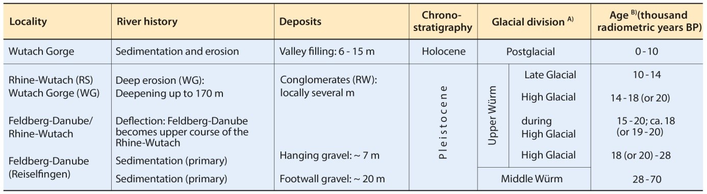
2.3 Stratigraphy and Time
Stratigraphically, the timing of avulsion of the Feldberg-Danube is placed within the High Glacial (Upper Würm, Pleistocene; Tab. 1). Already, Erb (1937) had correlated the occurrence of crystalline Black Forest pebbles in the terrace gravels of the Lower Wutach River with the Schaffhausen level of the Rhine Glacier, which corresponds to its maximal extent. The occurrence of the Laacher See Tephra (an important Central European stratigraphic marker [Kotulla 2016]) in the relict valley of the Aitrach, as well as in the Feldsee-Moor near the Feldsee (close to Feldberg summit), indicates that avulsion must have occurred before the eruption of the Laacher See Volcano (Alleröd, Late Glacial), and that at this time the Feldberg region was largely ice-free.
Radiometric age determinations (radiocarbon method) limit the avulsion of the Feldberg-Danube to a temporal window between about 11,000 and 26,000 conventional 14C-years BP. While Hebestreit et al. (1993) further narrow this interval via extrapolation to 15-20 thousand years BP, Pfaffenberger and Schiedek (1993) correlate the top of the Feldberg-Danube gravel body with the maximum extension of Würm glaciation (or shortly thereafter), which was assumed to be about 18 thousand years BP. Finally, Hebestreit (1995, 2016) anchors the avulsion at 19-20 thousand years BP, just before the Würm maximal extension (Tab. 1).
3. Valley Incision
3.1 Duration
The Wutach River is thought to have incised to its lowest level in about 6,000 or 10,000 years (Ricken & Einsele 1993, Hebestreit 2016). Pfaffenberger and Schiedek (1993) correlate mapped terraces in the Gutach, Haslach, and upper Wutach valleys (levels I-V) with glacier ice margins, formed when the glacier retreat halted for a while, which show geomorphological similarities to moraine ramparts. These terraces had already been assigned estimated 14C-ages within the framework of a radiometrically based age model. Thus, in the area of the Haslach mouth, Pfaffenberger and Schiedek (1993) estimate a time span of 2,000 to 3,000 years for the erosion of about 25 m into the unconsolidated sediments (up to level II). The Haslach mouth is located within the crystalline section of the Wutach Gorge and has a total depth of 70 m. Subsequently, based on the age estimates, the river would have deepened mainly into crystalline rocks: by 13 m in 1,000-2,500 years (to level III), by another 10 m in less than 2,000 years (to level IV), and finally by 23 m in 2,000-3,000 years (to level V). Ricken and Einsele (1993, p. 25) mention that this suggested time frame is uncertain, and Pfaffenberger and Schiedek (1993, p. 67) comment that this is an attempt to interpret the erosion history in the Haslach-Gutach area.
With exception of level Ia, the basal terrace, these terrace levels cannot be traced into the main gorge. Hebestreit (1995, p. 38) assigns some presumed terrace relicts to terrace level II. Consequently, the gorge is supposed to have been half deepened about 15,000 years ago and to have reached the present valley floor already at the beginning of the Holocene, about 11,000 years BP (Hebestreit 2016). Bauer & Knipping (1993) had reported 14C-ages of up to 12,500 years BP (corrected 11,000 years BP) for calcareous tuffs close to the valley floor. Finally, Hebestreit (2016) calculated mean deepening rates of 11 m/1,000 years at the location Schattenmühle and up to 20 m/1,000 years at Achdorf and the Wutach bend.
In any case, it is assumed that erosion was completed in the Pleistocene (Tab. 1) and that the valley slopes had already largely reached their present state (Ricken & Einsele 1993, p. 16). In the Holocene, the valley floor was even filled with a 6 to 15 m thick gravel layer (Kaspar et al. 1993, p. 110). Accordingly, the Wutach River has not actively eroded the gorge since the beginning of the Holocene. Thus, river avulsion and formation of the Wutach Gorge are directly related to the melting of the Feldberg glacier, and consequently also to availability and runoff of large amounts of water.
3.2 Mechanisms
According to Hebestreit (1995, p. 75), the deepening of the gorge occurred gradually by headwater erosion after the avulsion event (Tab. 1), with intermittent phases of incision. Climatically cooler phases were dominated by slower erosion and terrace formation. On the other hand, climatically warmer phases were characterized by extensive and rapid erosion. In this context, even minor changes in runoff conditions could have led to the development of terrace stages. However, Hebestreit (1995, p. 77) admits that starting points of headwater erosion (breaks in slope) are not evident.
According to Pfaffenberger & Schiedek (1993, p. 68), the deepening into the loose sediments of the low terrace forming levels Ib-IIe indicates a variable river dynamic, which may be caused by short-term climatic fluctuations. High river discharge rates would have increased erosion in flood periods. This type of description suggests episodic erosion, but is based on punctual events – pointedly, yearly flood seasons – repeating over a time period of many thousands of years, ultimately equating to a model of gradual, incremental erosion.
3.3 Avulsion and deepening – A question of magnitude?
With the formation of the Wutach Gorge, 2.5 km³ of rock have been cleared by erosion, including side valleys. Of this, about 50-60% is accounted for by mudstones, about 30% by carbonates and sulfates, and about 10% by crystalline rocks (Hebestreit 1995, p. 81). Westphal (1989, p. 189) describes the erosional output as unusual.
Large, fluviatile erosion rates can obviously only be achieved by water flows with higher discharge magnitudes. This is shown by exceptional occurrences of flood events in connection with operation and spillovers of dammed reservoirs. Massive erosion of hard bedrock has created new gorges within days, recently at Oroville Dam in California (Nalin & Kotulla 2018) or Lake Gorge in Texas in 2002 (Lamb & Fonstad 2010). At the Ricobayo Dam spillway in Spain, flooding from 1933 to 1936 resulted in five significant erosion events. Four of the five drastic scour events occurred during one day only (Anton et al. 2015). Erosion by these five events caused a headwater retreat of the unlined spillway of 270 m, a deepening of ⁓100 m and a widening of 160 m. Anton et al. (2015) estimate the discharge rates at 80 to 1,000 m³/s and conclude that already small to moderate floods in the range of about 100 to 1,500 m³/s are able to cause exceptional erosion. The discharge rates at the Oroville Dam and Gorge Lake were up to 2,000-3,000 m³/s higher.
The "Holocene Wutach" was not and is not capable of provoking deep erosion. The highest flood discharge ever measured was 317 m³/s on 15.02.1990 (LUBW 2011, p. 78). Terrestrial flood events with extremely large discharge rates in the range of 106 m³/s, called mega-floods (Baker 2013, Kotulla 2014), are, among other things, associated with the collapse of enormous ice masses at the end of the Ice Age. It can be assumed that smaller flood events occurred more frequently, also caused by relatively smaller ice masses such as the Feldberg Glacier with a supposed area of 700 km², a thickness of 50 m on the heights to 300 m in the valleys, and a length of glacier tongues of up to 25 km (Günther 2010, p. 117). Thus, it is quite conceivable that discharge rates of magnitudes of 103 to 104 m3/s were necessary to provide the unusual erosional output for the deepening of the gorge.
4. Scenarios of catastrophic flood events
Taking up ideas already mentioned by Erb (1937), the following catastrophic initial event is conceivable: Possibly triggered by a sudden release of large melt water volumes of the Feldberg Glacier, for example by a complete or partial emptying of one or several sub- or proglacial temporary meltwater reservoirs, a rapid flooding and accumulation occurs in the valley of the Feldberg-Danube. As a result, a critical threshold is exceeded at the probably shallow watershed southwest of Blumberg, causing an overflow and consequently the natural dam breaks by water pressure and underwashing.
With the abrupt river outbreak, water masses of the upper course of the Feldberg-Danube, including subsequent melt waters, and of parts of its lower course (today's Aitrach relict valley) rush to the lowest point towards the valley of the Rhine-Wutach. Loose sediments like crystalline gravels, claystones, and limestones are also increasingly taken up due to the increasing hydrodynamic energy. Floodwaters thus loaded with sediment begin to deeply erode bedrock up to the beginning of the valley of the Rhine-Wutach, and finally also the valley floor of the Rhine-Wutach. Furthermore, it is conceivable that temporary melt water lakes formed several times and sudden releases of large water volumes occurred repeatedly.
No specific indicators are given to support a gradual deepening of the gorge. The “episodic-gradual” model of erosion is inferred from the radiometric geochronological framework and a corresponding temporal correlation with the river terraces (see chapter 3.1; Pfaffenberger & Schiedeck 1993). The evidence for high energetic flood events is also minimal, with a few considerations that could be supportive of this hypothesis. Areas of further investigation include the following:
1) Distribution area of the Feldberg glacier: Is there evidence for melt water basins? An identification or reconstruction of temporary basins has not been produced so far. It is possible that relict structures may have been preserved if the basin margins were not formed by ice.
2) Valley of the Feldberg-Danube: Is there evidence for high water levels of the Feldberg-Danube? It is possible that water level marks were formed. Admittedly, so far, no indications of those have been found. However, the possibility of preservation is doubtful, because landslides and soil creeps have demonstrably modified the valley flanks to a great extent.
3) Wutach Gorge: Is there evidence for significant erosion events? Based on the terrace structure in the Haslach, Gutach and Upper Wutach valleys, correlations to the upper valley parts as well as to the main part of the Gorge until the Wutach bend are questionable. The different, partly schematic cross-sections of the Upper Wutach Valley (e.g. Pfaffenberger & Schiedek 1993, p. 71) can also be interpreted as only two main deepening events: one related to levels Ia-Ie, and one related to levels IIa-V. The partly rectangular valley cross-sections and small valley widths also indicate highly energetic, vertical erosion.
4) Lower course of the Wutach River: Is there evidence for significant erosion and/or sedimentation events? Sediments of the eroded bedrock first occur in the lower course of the Wutach River south of Grimmelshofen, about 7.5 km south of Achdorf (Fig. 3b). The sediments include conglomerates with high content of crystalline clasts, components which could only be transported into the valley of the Rhine-Wutach during or after the avulsion of the Feldberg-Danube. They are directly overlying limestones of the Lower Muschelkalk (Triassic). According to Hebestreit (1995, p. 54), the deposition of these conglomerates must have been preceded by an erosional phase that either removed the older Würm-age valley fill or even slightly deepened the valley base just before gravel accumulation. An initial flood event could have caused this erosion and deposited sands and gravels as the hydrodynamic energy subsided.
In the area of the confluence with the Rhine, south of Wutöschingen, gravel deposits with such lithic clasts of crystalline rocks occur above and beside each other in low terrace levels; their interfingering reflects complex river dynamics (Hebestreit 1995, p. 69). These clasts could represent successive redeposition or downstream relocation. However, it may be possible that only one sedimentation event is represented by these deposits. This would have to be verified by further analyses. The preservation of only one sedimentation event would favour a main, high magnitude flood event.
6. Summary and Conclusions
Avulsion of the Feldberg-Danube and formation of the Wutach Gorge are directly related in time and origin to the melting of the Feldberg Glacier. A few higher energy flood events are proposed as the mechanism for providing the main erosive output. Some circumstantial evidence points in this direction. Incremental, low-energy (gradual) erosion – even including periods of flood waters (cf. present-day Wutach River) – is not an effective mechanism for deep erosion of the required magnitude.[1] A catastrophic outburst of the Feldberg-Danube is hypothesized as the initial event and possible major event. Compared to known flood events, it is assumed that major incision of the Wutach Gorge lasted only a few weeks in total. New findings are expected from the use of high-resolution laser scans of the terrain surface (light detection and ranging, LiDAR) to compute a digital terrain model without vegetation (cf. Beckenbach 2016), as well as hydraulic considerations and numerical model calculations.
7. Acknowledgements
Dr. Reinhard Junker and Dr. Martin Ernst reviewed the German version of the manuscript and contributed with valuable comments. Frank Meyer and Johannes Weiss prepared the graphics. Achim Mende provided aerial pictures, which allow a large-scale view of the Gorge. The ‘Studiengemeinschaft Wort und Wissen’ has been conducting hikes and excursions in the Wutach Gorge for many years. Through participation in the excursions, the author’s interest in the formation of the Wutach Gorge has been awakened. Rafael Schäffer prepared an English translation. Geoscience Research Institute is responsible for the copy-editing of the manuscript.
8. References
Ahnert, F. (2015): Einführung in die Geomorphologie. UTB, Stuttgart, 5th edition, 458 p.
Anton, L., Mather, A.E., Stokes, M., Munoz-Martin, A. & De Vincente, G. (2015): Exceptional river gorge formation from unexceptional floods. Nature Communications 6, 7963.
Baker, V.R. (2013): Global late Quaternary fluvial paleohydrology: with special emphasis on paleofloods and megafloods. In: Shroder, J. & Wohl, E. (Eds.): Treatise on Geomorphology. Academic Press, San Diego, vol. 9, Fluvial Geomorphology, 511–527.
Bauer, M. & Einsele, G. (1993): Einführung in die Geologie und das Klima des Wutachgebietes. Tübinger Geowissenschaftliche Arbeiten – Reihe C 15, 1-15.
Bauer, M. & Knipping, M. (1993): 14C-Daten und paläobotanische Befunde von Kalktuffvorkommen: Rückschlüsse auf das Mindestalter der Wutachschlucht. Tübinger Geowissenschaftliche Arbeiten – Reihe C 15, 74-84.
Beckenbach, E. (2016): Geological interpretation of the digital terrain model (DTM) of Baden-Württemberg (Southwestern Germany). Dissertation, University of Stuttgart, 307 p.
Busche, D., Kempf, J. & Stengel, I. (2005): Landschaftsformen der Erde – Bildatlas der Geomorphologie. Primus wbg, Darmstadt, 1st edition, 360 p.
Cloos, H. (1947): Gespräche mit der Erde – geologische Welt- und Lebensfahrt. Piper, Munich, 409 p.
Cloos, H. (1953): Conversation with the Earth. Alfred A. Knopf, New York, 413 p.
Erb, L. (1937): Der Zeitpunkt der Wutachablenkung und die Parallelisierung der würmeiszeitlichen Stadien des Schwarzwalds mit denen des Rheingletschers. Mitteilungen des Badischen Landesvereins für Naturkunde und Naturschutz NF 3, 314-319.
Geyer, M. & Gwinner, M.P. (2011): Geologie von Baden-Württemberg. Schweizerbart, Stuttgart, 5th edition, 627 p.
Günther, D. (2010): Der Schwarzwald uns seine Umgebung – Geologie, Mineralogie, Bergbau, Umwelt und Geotourismus. Sammlung geologischer Führer 102, 1-302.
Hebestreit, C., Schiedek, T., Bauer, M. & Pfaffenberger, C. (1993): Zeitmarken der Wutacheintiefung – Terrassenkorrelation, Terrassenstratigraphie und Kalktuffe. Jahresberichte und Mitteilungen des Oberrheinischen Geologischen Vereins NF 75, 291-312.
Hebestreit, C. (1995): Zur jungpleistozänen und holozänen Entwicklung der Wutach (SW-Deutschland). Tübinger Geowissenschaftliche Arbeiten – Reihe C 25, 1-88.
Hebestreit, C. (2016): Wutachregion – Geologisches Kleinod im Südwesten. Quelle & Meyer, Wiebelsheim, 152 p.
Jordan, U. (1993): Die holozänen Massenverlagerungen des Wutachgebietes (Südschwarzwald). Tübinger Geowissenschaftliche Arbeiten – Reihe C 16, 1-132.
Kaspar, E., Lubinski, T. & Hebestreit C. (1993): Zur Talfüllung und jüngeren Entwicklung der Wutach. Tübinger Geowissenschaftliche Arbeiten – Reihe C 15, 110-114.
Kotulla, M. (2014): Megafluten. Studium Integrale Journal 21, 4-11.
Kotulla, M. (2016): Der explosive Ausbruch des Laacher-See-Vulkans. Studium Integrale Journal 23, 111-116.
Lamb, M.P. & Fonstad, M.A. (2010): Rapid formation of a modern bedrock Gorge by a single flood event. Nature Geoscience 3, 477-481.
Liehl, E. (1988): Morphologie des Wutachgebietes. In: Liehl, E. (Ed.): Die Wutach. Preprint of 1971, Freiburg, p. 1-30.
LUBW (2011): Deutsches Gewässerkundliches Jahrbuch – Rheingebiet, Teil 1, Hoch- und Oberrhein 2009. Landesamt für Umwelt, Messungen und Naturschutz, Karlsruhe, 159 p.
Metz, B. & Sauer, H. (2012): Geomorphologie und Landschaftsentwicklung. In: Regional Council Freiburg (Ed.): Der Feldberg – Subalpine Insel im Schwarzwald. Thorbecke, Ostfildern, 14-62.
Nalin, R. & Kotulla, M. (2018): Rapid Bedrock Incision by Water Stream Outburst: The Case of the Oroville Dam (California, USA). https://www.grisda.org/rapid-bedrock-incision-by-water-stream-outburst-the-case-of-the-oroville-dam-california-usa-1
Paul, W. (1988): Von der spätjurassischen (frühkretazischen?) Landwerdung bis zur Gegenwart: Portlandium (Valendis?) bis Holozän. In: Liehl, E. (Ed.): Die Wutach. Preprint of 1971, Freiburg, p. 135-194.
Pfaffenberger, C. & Schiedek, T. (1993): Zeitmarken der Wutach-Eintiefung: fluviale Terrassen und ihre Korrelation mit würmzeitlichen Vereisungsphasen des Südschwarzwaldes. Tübinger Geowissenschaftliche Arbeiten Reihe C 15, 66-73.
Plug, C. (2020): S2A3 Biographical Database of Southern African Science – Prof Hans Cloos (geology). http://www.s2a3.org.za/bio/Biograph_final.php?serial=529, Last updated 23/04/2020, accessed on 23rd January 2023
Rahm, G. (1961): Neue Gesichtspunkte zur Wutachablenkung. Berichte der naturforschenden Gesellschaft Freiburg 51, 133-136.
Ricken, W. & Einsele G. (1993): Entstehung der Wutachschlucht: Übersicht der Prozeßabfolgen. Tübinger Geowissenschaftliche Arbeiten Reihe C 15, 16-44.
Schnarrenberger, C. & Schurhammer H. (1936): Naturwissenschaftliche Wanderung durch das obere Wutachtal. Mitteilungen des Badischen Landesvereins für Naturkunde und Naturschutz NF 3, 285-289.
Walker, M., Johnsen, S., Rasmussen, S.O., Steffensen, J.P., Popp, T., Gibbard, P., Hoek, W., Lowe, J., Andrews, J., Bjorck, S., Cwynar, L., Hughen, K., Kershaw, P., Kromer, B., Litt, T., Lowe, D.J., Nakagawa, T., Newnham, R. & Schwande, J. (2009): The Global Stratotype Section and Point (GSSP) for the base of the Holocene Series/Epoch (Quaternary System/Period) in the NGRIP ice core. Episodes 31, 264-267.
Wegmann, C.E. (1935): Gletschermurgang im Sueß-Land (Nordostgrönland). Mitteilungen der Naturforschenden Gesellschaft Schaffhausen 12, 35-58.
Westphal, F. (1989): Feldbergdonau und Wutachschlucht, zur Entwicklung einer jungen Flußlandschaft. Jahresberichte und Mitteilungen des Oberrheinischen Geologischen Vereins NF 71, 189-197.
Zepp, H. (2014): Geomorphologie – Eine Einführung. Schöningh, Paderborn, 6th edition, 402 p.
Endnote
[1] See also “Gradualism vs catastrophism in landscape evolution.” This was the title of the Regional Conference of the International Association of Geomorphologists in 2015.
Michael Kotulla
Studiengemeinschaft Wort und Wissen, Rosenbergweg 29, 72270 Baiersbronn, Germany; m.kotulla@wort-und-wissen.de