A REVIEW OF RECENT DATA FROM THE REGION OF THE ARK-SHAPED FORMATION IN THE TENDUREK MOUNTAINS OF EASTERN TURKEY
by William H. Shea Professor of Old Testament Andrews University, Berrien Springs, Michigan
WHAT THIS ARTICLE IS ABOUT
It has been widely believed that creationism would receive a significant advance if Noah’s Ark were to be found. A majority of efforts, both exploratory and literary, have been focused on the traditional site — the Ararat Mountains (Agri Dagh). The present article questions the value of searching on Ararat and proposes that the boat-shaped geologic feature on another mountain several miles away be reexamined. Supporting evidence is provided by the description of two large stones which closely resemble stone anchors used by seafarers millennia ago. A case is made for the genuineness of the stone anchors, and the conclusion is that the search for the Ark’s remains should be moved to the Tendurek Mountains.
Have the searchers for Noah's Ark focused their attention on the wrong mountain? Dr. Shea discusses evidence for the Ark's remains in another location - the Tendurek Mountains of eastern Turkey.
I. The Search for the Ark on Mt. Ararat
Through the centuries there have been isolated attempts to locate Noah's Ark, but these searches have only been pursued with particular vigor and persistence since World War II. The basic bibliography of materials relating to this search has been compiled by Violet M. Cummings [1]. While there are some exceptions to the format [2], more recent books and movies on this subject generally begin with a condensation of her materials followed by a description of the author's expedition to the traditional Mount Ararat [3]. The results of these investigations might be summarized as follows.
Cummings' literature survey shows that there is no evidence earlier than the 4th century A.D. which identifies the traditional Mt. Ararat (Bü Agri Dagh) as the site where Noah's Ark landed [4].
Aerial photographs of this mountain have located the supposed outlines of Noah's Ark on a ledge overlooking the deep Ahora gorge [5].
Old wood has been brought down from this mountain on two occasions, by F. Navarra in 1955 and by the SEARCH group in 1969 [6]. The wood, obviously hand-tooled, is said to be white oak and has been radiocarbon dated on several occasions to the second half of the first millennium A.D. [7]. Considering the fact that these are the only significant results that have been produced by more than thirty expeditions to Mt. Ararat over the past two decades [8], these rather meager findings raise the question of whether the search is located in the right area.
Because of adverse political conditions, such searches have been almost completely suspended for the past five years. Two expeditions to Mt. Ararat were planned in the summer of 1979, one of which did at least travel some in eastern Turkey. Since no results of these attempts have been publicized as yet, I suspect that whatever they were able to accomplish in the field was not of major importance and does not change the picture of the results summarized above to a significant degree. There are a number of reasons why such meager results might have been expected from this mountain, and these may be itemized as follows:
Genesis 8:4 merely locates the landing site of the Ark in the "mountains" (plural in the Hebrew) of Ararat. While the traditional Mt. Ararat does lie within the territory that once was ruled by the ancient kingdom of Urartu, the name of which is related to the biblical name of Ararat, Genesis does not provide any specific evidence that the mountain upon which so much effort has been expended by these expeditions is the correct one.
Identification of the Ark's site rests upon a very late tradition from the Christian era. This same era was one during which an extensive pilgrimage mentality developed in Byzantine Christianity. Armenian Christian inscriptions, for example, are known as far south as the vicinity of St. Catherine's monastery in the southern Sinai peninsula.
Deprived of any of the sites that Jesus visited personally, Armenian Christians quite naturally developed a pilgrimage tradition connected with something close at hand. From this line of thought it is easy to see why the site where Noah's Ark landed came to be attached to the traditional Mt. Ararat the highest, most outstanding mountain in the region.
Evidences for pilgrimages up this mountain have been found in several stations located at intervals along the trail, each having eight crosses carved in the rock face of the mountain. These have been documented in Bart LaRue's movie on the search for Noah's Ark. These crosses obviously were intended to represent the eight persons who were in the Ark according to Genesis 7:7. Further evidence for pilgrimages up this mountain comes from Armenian inscriptions at its foot, some of which have dates in the second half of the first millennium A.D.
Armenian Christian pilgrims ascending this mountain may well have built a shrine to venerate Noah. Since the pieces of wood brought down from the mountain date to this period, the most logical suggestion for their origin is from such a shrine. One can argue about the corrections necessary for radiocarbon dates from the 2nd millennium B.C. and earlier, but no valid reason has been advanced to explain why these radiocarbon dates from the 1st millennium A.D. should be discounted [9]. Since they are compatible with historical data in the vicinity of this mountain from this period of pilgrimages, it is natural to associate them with this development.
Scientific evaluation also poses problems for the identification of Agri Dagh as the mountain upon which the Ark landed because of its volcanic origin and its isolation from other nearby mountains. In addition, the glacial action of the ice pack high on that mountain makes it unlikely that any original Ark wood could have survived the millennia since the Ark supposedly landed there.
In summary, the traditions which have located the landing site of Noah's Ark on Agri Dagh are quite late, dating only to the first millennium of the Christian era. Since many of the holy sites venerated by Christians of the same period in Palestine can now be demonstrated to be historically and archaeologically incorrect, there is no particular reason why this tradition in Turkey should be an exception. These erroneous holy sites in Palestine represent cases in which a knowledge of the authentic site was lost within a few centuries. How much more then is the Mt. Ararat tradition questionable, since it is only attested in sources separated from the Flood by millennia? Aerial photography, radiocarbon dating of the wood, and scientific evaluation have not indicated that any remains of the Ark still are on Mt. Ararat or even that this was the mountain upon which it landed. Perhaps other locations in this region should also be considered in the search for that site.
II. The 1960 Expedition to the Tendurek Mountains
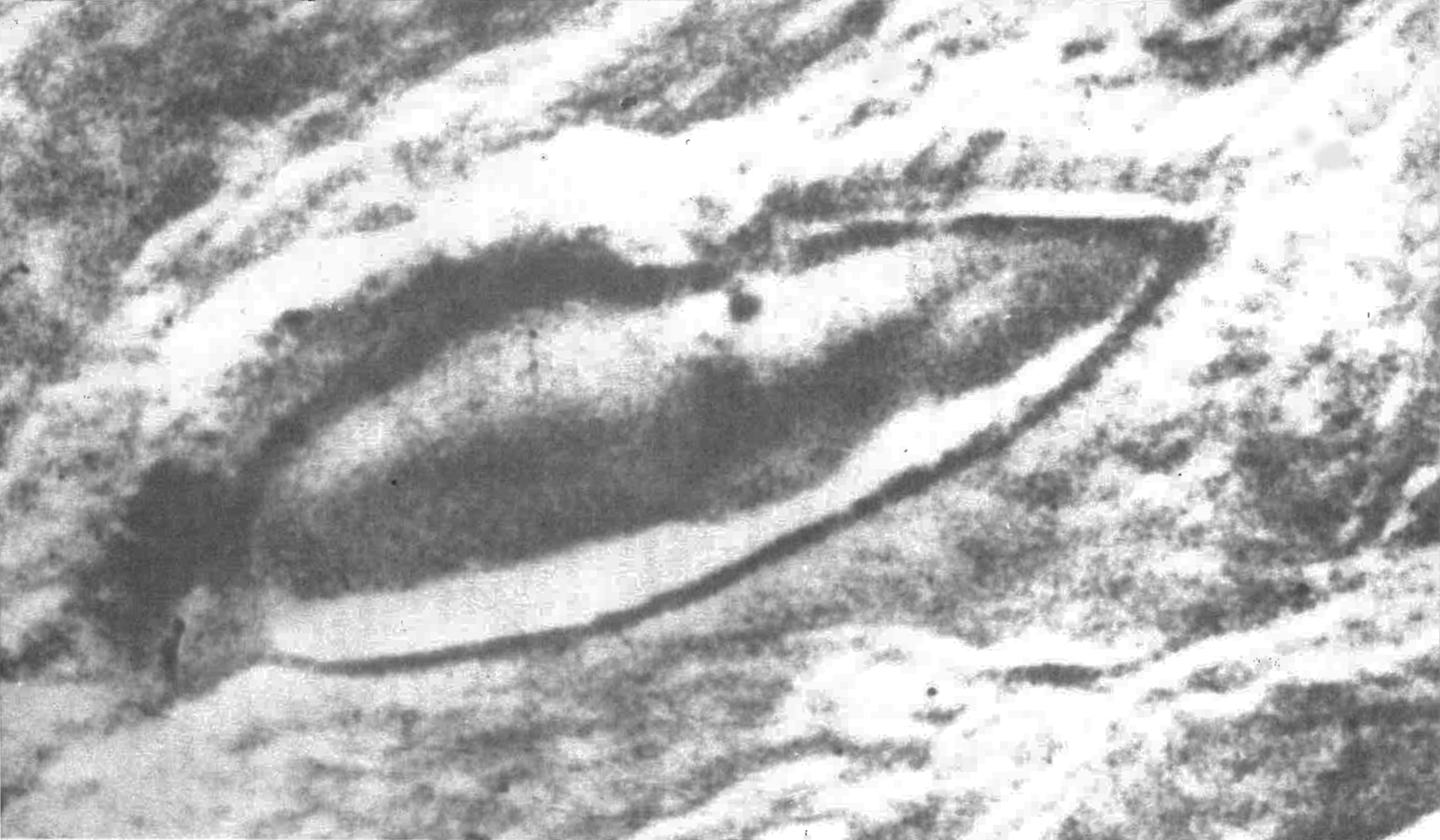
The only other site in this area which has received some attention in the search for the Ark is an isolated and unusually shaped formation at the 6,000 foot level of elevation in the Tendurek Mountains. It is located about 30 miles southwest of the traditional Mt. Ararat and about six miles west of the town of Dogubayazit, the home base of the expeditions that have attempted to climb Mt. Ararat. In the winter of 1959 a Turkish army captain named Ilhan Durupinar noted a ship-like outline in some aerial photographs of eastern Turkey (Figure 1). When news of this discovery reached the United States, an expedition to visit that site was organized. The story of this expedition has been told by R. Noorbergen in The Ark File[10]. On the negative side, the members of the expedition found no archaeological evidence for the Ark and consequently abandoned any further study there. On the positive side, the expedition confirmed the measurements of the formation that had previously been determined from the aerial photographs. The ship-like shape of this formation measured 500 feet in length, 150 feet at its widest point, and 20 feet high.
Two main criticisms might be made of the 1960 expedition. First, no geologist was included in the group, although the site turned out to be more of a geological problem than an archaeological one (see below). Second, the group might have abandoned its task prematurely. Influenced, at least to some extent, by second- and third-hand stories from then-deceased, elderly former residents claiming that the Ark was still intact at the traditional site, the team broke off exploration of this site rather abruptly when it did not meet their expectations that were based upon perhaps exaggerated legends. Given the millennia that passed between the Flood and 1960 A.D. when this expedition took place, it was rather unrealistic to expect that the Ark survived whole and intact.
FIGURE 1. Aerial photograph of the ship-shaped formation in the Tendurek Mountains. Photograph by R. Noorbergen. Reproduced by permission of Camera Press, Ltd., London, 6036-I.
FIGURE 1. Aerial photograph of the ship-shaped formation in the Tendurek Mountains. Photograph by R. Noorbergen. Reproduced by permission of Camera Press, Ltd., London, 6036-I.
III. The 1976 Reevaluation of the Tendurek Mountain Formation
Noorbergen's The Ark File was published in 1974. After reviewing the evidence from the chapter of his book that deals with the 1960 expedition and corresponding with a geologist who had visited the site in 1973, I published the suggestion that this formation should be reevaluated as a possible location of Noah's Ark [11]. Such a reevaluation should be undertaken without preconceived opinions about the kind of evidence we should expect from such a site.
From aerial photographs this formation looked as though it lay in a former lava flow (see Figure 1). Since no remains of the Ark are visible, it was suggested that the Ark may have burned as the result of volcanic activity. The precise nature of the flow around this formation has yet to be determined by direct geological observation. In the summer of 1977 a geologist suggested to me that this was a Pleistocene mud flow, but he still had no explanation for the ship-like formation itself [12]. Since the length of time from the flood must be measured in millennia, it is also possible that the remains of the Ark eventually disintegrated from weathering and decay. In either case the Ark itself would not remain, but rather a mold or cast of its hull made in the mud now hardened at the site where it came to rest.
The first point of special interest is the formation's obvious ship-like shape. On this I wrote earlier:
One need not be an expert in geology, archaeology, or nautical engineering to see that the outline in the photograph above obviously resembles that of the hull of a ship. This was what brought it to Ilhan Durupinar's attention, this was what caused some commotion when the aerial photograph of it was published in Life magazine, and this was what led to the 1960 expedition that went to examine it.
The expert in aerial photogrammetry from Ohio State University who read the film said of it before going to the field with the expedition, 'I have no doubt at all that this object is a ship. In my entire career I have never seen an object like this on a stereo photo.' This formation certainly does have the outline of the hull of a ship, which is a fact that no one has denied [13].
Some have objected on occasion that if this formation were related to Noah's Ark, it should have been more rectangular in shape. This criticism rests upon a preconceived opinion about the design according to which Noah's Ark had to be built. The biblical measurements for the Ark provide no direct indication of the hull's actual design. The same measurements have been applied to modern ships of a comparable size, which certainly do not have rectangular-shaped hulls. While the Ark was only intended for flotation and not for propelled navigation, a ship shaped like the outline of the Tendurek Mountain formation would probably have been less susceptible to damage in high seas than would a more rectangular hull. At the very least the shape of the Ark's hull is an open question that cannot of itself negate the possibility that this formation could be related to it.
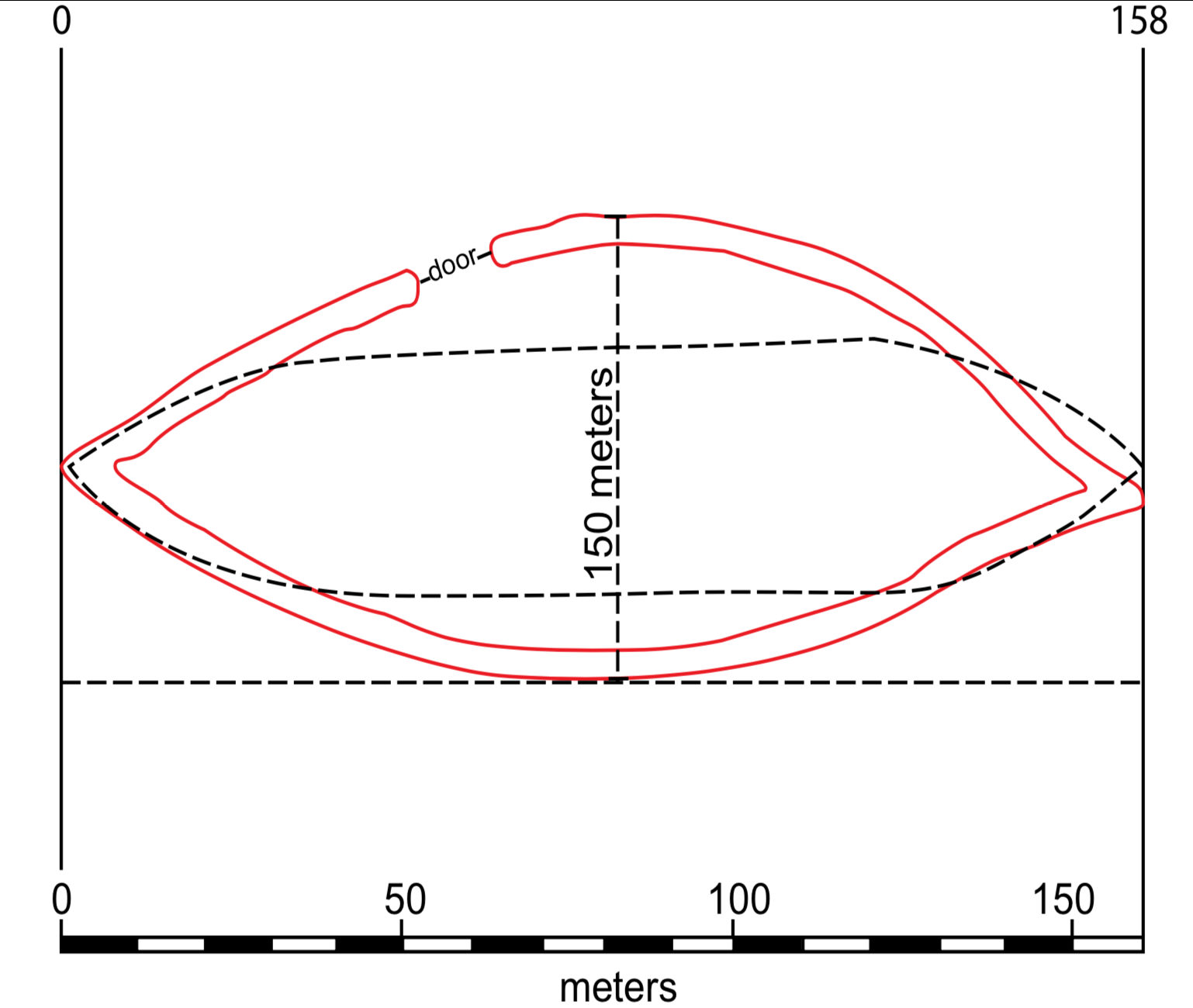
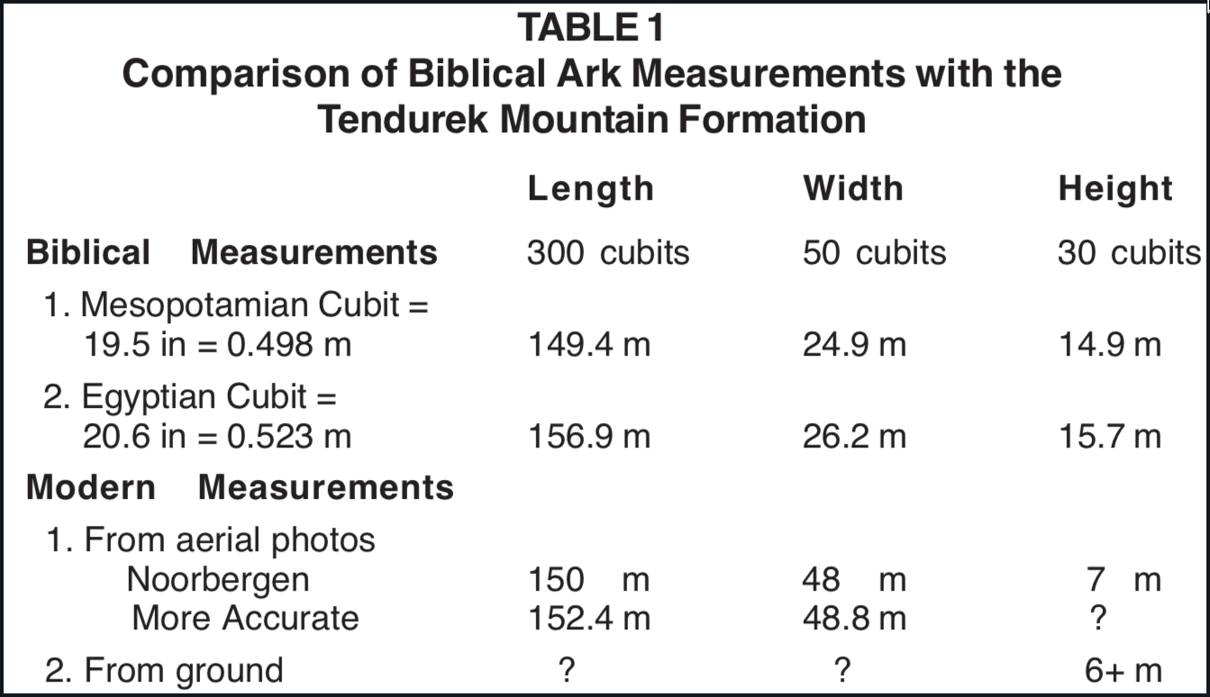
The second impressive point about the Tendurek Mountain formation when compared with the biblical description of the Ark is its measurements, especially its length (Figure 2; Table 1). Genesis 6:15 gives the measurements of Noah's Ark as 300 × 50 × 30 in terms of cubits. The measurements that appear with the plans of this formation in Noorbergen's book are 150 × 48 × 7 meters respectively [14]. According to the second set of more accurate measurements taken from the aerial photographs, this formation is said to have measured 500 feet long and 160 feet at its widest point [15]. Though the ground measurements have not been reported in detail, they were said to confirm the measurements made from the photographs [16].
FIGURE 2. A schematic comparison of the measurements of the Tendurek Mountain formation with the biblical measurements for Noah's Ark.
To compare these two sets of figures it is necessary to estimate the length of the cubit employed in the biblical record for the dimensions of the Ark. The length of the cubit varied from place to place and time to time in the ancient world [17]. While the use of an antediluvian cubit cannot be ruled out, it is just as likely, if not more so, that these measurements were given in terms of postdiluvian cubits. It is suggested by the very use of the Semitic word for cubit here, since it derives from a particular postdiluvial language family. It one compares the Mesopotamian cubit of 19.6 inches for the Ark's cubit with the original measurement of 150 meters for this formation, they are just about the same, at 490 feet.
In the times of the Israelite monarchy the Hebrew cubit varied from the "old" cubit of 17.5 inches (2 Chronicles 3:3, Revised Standard Version) to the "long" cubit (Ezekiel 40:5; 43:13) which was approximately equivalent to the Egyptian cubit of 20.6 inches. Moses has been credited with the authorship of this passage of Scripture, and the cubit with which he was familiar during his Egyptian education may well have been the standard by which he set down these figures. If one compares the longer measurement of 500 feet for this formation with the biblical measurement for the length of the Ark according to the Egyptian cubit, then the latter comes out only 15 feet longer than the former. Since minor variables are involved in both figures they should not be pressed too far, but even allowing for such variables it is obvious that they correspond very closely.
This boat-shaped formation currently averages around 20 feet in height along its outer margin. By any standard of cubit, that is less than half of the 30-cubit height of the Ark given in Genesis 6:15. The way in which it was proposed above that this formation may have been formed, however, would suggest that it never was as high as the side of the Ark, even before significant weathering took place here; consequently, this discrepancy is not significant. However, the discrepancy between the width of these two objects is significant, since the 50-meter width of this formation at its widest point is about twice as wide as the 50 cubits of Noah's Ark. Several possibilities should be considered when an explanation for this discrepancy is sought.
In the first place, we do not know precisely how this biblical measurement for the width of the Ark was made. The ancients practiced mathematics differently than we do now in some respects. The use of inclusive reckoning whereby any fraction came to stand for the whole is one example (cf. 2 Kings 18:9-10). If some sort of averaging was employed to measure the width of an elliptical hull, then that figure might have come out differently than the way we now measure the widest points on this formation.
Secondly, assuming that the figure originally written in the biblical text did represent the width of the Ark at its widest point, we should consider the possibility that this original figure could have been garbled in the course of its transmission through successive recensions of the biblical text. The study of textual criticism clearly indicates that numbers were a feature of the text that suffered from alterations most easily in the course of their scribal transmission.
We also should allow for the possibility that this formation may now be wider than it was originally. It is interesting to note in this connection what marine archaeologists have learned about shipwrecks that have rested on the bottom of the Mediterranean Sea for centuries and millennia. As ships have disintegrated, in some cases, sections of their hulls have fallen outwards [18]. While the conditions under which these ships fell apart were not identical to those obtained in the Tendurek Mountains, it is possible that any remains of the Ark here could have suffered a similar fate.
Another possibility is that a geologic event(s) could have caused some spreading or fracturing. We now know that an earthquake damaged this formation between the summers of 1977 and 1979 (see below). Since this formation is located in a geologically active region, such damage could also have occurred in the more remote past.
Perhaps the most important point about this comparison of measurements is that its length corresponds quite closely with the measurements given in the Bible. Even if the bow and stern had fallen off as it disintegrated, the measurements of the remains of the Ark's length would not have altered significantly. Since the Ark was only 1/6 as wide as it was long, however, destruction or disintegration could have altered its configuration and dimensions more significantly in width. In other words, when compared with the biblical measurements of the Ark, the length of this formation is of greatest significance, its width is of intermediate significance, and its height is of least significance. In the dimension that counts the most the length the fit between this formation and measurements of the Ark in the Bible is most precise.
IV. The 1977 Exploration of the Tendurek Mountain Formation
In the summer of 1977, independent of the article I published on this subject, Ronald E. Wyatt of Madison, Tennessee, visited this site to investigate its possible relationship to Noah's Ark. Although he was not able to explore the formation itself as thoroughly as he wished because of difficulties with the local villagers, he still made a significant finding in the vicinity of the formation.
There are two roads one to the northeast, the other to the southeast leading to this formation in the Tendurek Mountains. Wyatt approached it from the former route in the summer of 1977, whereas the 1960 expedition approached it from the latter route. He was thus able to make observations that could not have been made by members of the 1960 expedition.
The distance from the northeastern road to the ship-shaped formation is about two miles. About halfway there, Wyatt came upon a cemetery which did not look as though it has been used in modern times. Of itself this cemetery is not particularly remarkable for our present purposes. What is noteworthy is one of its stones that is distinct from those used as headstones.
For the purposes of our continuing discussion this stone has been designated Stone A. A similar stone, designated Stone B and described below, was found one-half mile west of Stone A. A side view of Stone A is shown in Figure 3. No measurements of this stone were made, but it is about the same height as Stone B, or about eight feet. The specific configuration of this stone is important. Broad when viewed from its side, it is relatively thin when viewed from an edgewise profile or end on. Byzantine crosses have been carved on one side. Further details can be determined by comparison with crosses carved in Stone B (Figure 4). More significant is the round hole that can be seen along its upper edge from the side view.
FIGURE 3. Stone Anchor A; drawn from R. Wyatt's photograph by J. Jackson.FIGURE 4. Stone Anchor B; drawn from R. Wyatt's photograph by J. Jackson.
Wyatt has suggested that these distinctive stones should be identified as stone anchors. The leading authority in marine archaeology on the subject of stone anchors is Honor Frost. She has contributed a number of studies on this subject, her best summary statement being published in 1973, "Ancore, the potsherds of marine archaeology: on the recording of pierced stones from the Mediterranean" [19]. Her study provides a useful background against which these two pierced stones from the Tendurek Mountains can be evaluated as possible stone anchors.
Most of the stone anchors from antiquity have been recovered by divers from the floor of the Mediterranean. The stone anchors found in excavations of sites on land, however, are particularly important because they come from archaeological contexts that can be dated with relative accuracy. Stone anchors excavated on land have come from temples where they had been set up as sacred objects, from tombs, from stonemasons' workshops, and from the walls of various kinds of buildings where they were used secondarily as building stones. Most of the stone anchors recovered from the sea floor come from the shallows where ships that could not sail against contrary winds had to drop anchor and wait for more favorable conditions until they could resume their voyages. From the archaeologist's point of view, the number of stone anchors lost at sea by ancient ships appears to be "inexhaustible" [20]. Lost stone anchors mark ancient sealanes and hint at the habits of those who used them. Unfortunately for professional archaeologists, many stone anchors have been removed from the ocean floor by amateur divers without any recording of such finds. From Frost's corpus I have selected here five examples of some of the largest stone anchors known [21]:
An Egyptian anchor inscribed with the hieroglyph nfr which means, "good, perfect, beautiful.'' Excavated from a stratum dated to 2200 B.C. in a temple precinct at Byblos on the coast of Lebanon and now housed in the Beirut National Museum. Weight: 188.5 kg.
A limestone anchor excavated among votive obelisks in a temple at Byblos dated in the 19th century B.C. This triangular type of anchor was typically Byblian. Estimated weight: 30 kg.
A Ugaritic anchor from the temple of Baal on the coast of Syria, possibly from the 19th century B.C. level. Such anchors were squatter, thicker, and heavier than those used at Byblos. Weight: 700 kg, one of the heaviest if not the heaviest of stone anchors ever found.
An anchor used as building stone on Cyprus in the 13th century B.C. It is similar in shape to Ugaritic anchors. Estimated weight: over 500 kg.
An anchor found by the sea wall of an ancient port on Cyprus. Its incised script was dated to the 14th century B.C. Tapered at the top, it has a large rope hole. Estimated original weight: 150 kg.
The coming of Iron to the ancient world around 1200 B.C. brought the development of iron anchors and a decline in the use of stone anchors.
Pierced stones at either extreme of the weight range, wherever found, are the easiest to date and identify. They are consequently the most significant, but (particularly on land) are often cast aside. Not fitting in with preconceived notions, they are considered to be too big or too small to have served as anchors. Anchor stones that are too heavy for one man to handle (i.e., in the 50-700 kg range) will, however, almost certainly antedate the introduction of metal and wooden anchors during the Iron Age. Once lead-stocked anchors became current on all important craft, stones became the poor man's anchors and, since the poor man had a small boat, the size of stone anchors diminished accordingly [22].
The general and natural rule seems to be that the larger the anchor discovered by modern archaeologists the larger the ship that it must have been used on in antiquity. Frost has estimated, for example, that the use of half-ton Bronze Age stone anchors prove the existence of ships of at least 200 tons. This has implications for our understanding of other aspects of ancient shipping:
The existence of nineteenth-century B.C. half-ton anchors at Ugarit (and in the sea) proved that a number of Bronze Age ships were far larger than hitherto supposed so large, indeed, that they would have been unbeachable. As a corollary, a few major proto-harbours must have existed along the shelterless Levant coast, in order to ensure trading by such large vessels[23].
With this survey of Bronze Age stone anchors in mind, let us compare the two pierced stones found in the Tendurek Mountains of eastern Turkey. In general configuration, the latter match the former on all important counts. These two pierced stones are, like the large Bronze Age stone anchors from the Mediterranean, tall, broad when viewed from the side, thin when viewed edgewise or end on, tapered towards the top and have rope holes at their upper ends. On all of these counts, therefore, they qualify quite readily as fitting the picture of stone anchors, as Wyatt originally identified them.
Only in size or scale do these two stones differ significantly from their Mediterranean counterparts. They are far larger than any of the anchor stones that have been recovered from the Mediterranean or from excavations along its coast. While the heaviest stone anchors from the Mediterranean weigh about 700 kg and stand about 1.1 or 1.2 meters high, these two anchor-like stones from the Tendurek Mountains stand about 2.5 meters or 8 feet high. We can give only a very gross estimate of their weight, but they must easily weigh several tons. If the size of the stone anchors implies the size of the boat or ship on which they were used, as is the case for half-ton anchors at Ugarit, how much more should it be true for these stone anchors weighing several tons that were found in eastern Turkey. Indeed they are, by this standard, Ark-sized stone anchors.
Given the conclusion that these stones are anchors, we may next ask, who made them, where did they come from, and how did they arrive at their current location? As to the question of who made them, two current possibilities appear reasonable. Either they were part of the original equipment of Noah's Ark, or they were made much later by Armenian Christians to commemorate that voyage and its participants. A later origin might be argued from the fact that Byzantine crosses were incised upon the sides of these stone anchors. The crosses could have been cut long after the anchors had been quarried, just as the crosses cut in the rock at the stations along the trail up Agri Dagh were a late development.
One may question how familiar the Armenian Christians of this region would have been with stone anchors for sailing ships. Lake Van to the southwest is the nearest large body of navigable water, and any boats on that lake using stone anchors presumably would have used relatively small ones, similar to the small stone anchors still used by the fishermen in the Mediterranean today [24]. If Armenian Christians had quarried these stones to be commemorative stelae, there would not have been any real reason to bore rope holes in them. It seems evident that these objects were recognized as stone anchors. The least one can say is that if Armenian Christians did quarry these stones, in all likelihood they did so to connect this immediate vicinity with the commemoration of Noah's Ark.
The second question concerns the source of stone anchors. Since they lie only a mile to the northeast of the Ark-shaped formation, it is likely that Armenian Christians found them there and subsequently moved them to their cemetery. This chain of events answers the third question of how they reached their present location. A petrological analysis of pieces from these stone anchors would be of considerable interest in evaluating them. Such samples should not be difficult to obtain, since the local villagers are already chipping pieces from one of the anchors to sell to tourists as souvenirs from the Ark!
One might object that the biblical description of the Ark and the Flood says nothing about anchors, but neither does this argument from silence say that the Ark did not have anchors. There were probably many things aboard the Ark that were not mentioned in Genesis.
V. The 1979 Exploration of the Tendurek Mountain Formation
In September of 1979 Ron Wyatt returned to the Tendurek Mountain formation for more surface exploration, accompanied this time by Manuk Benzatyan as his translator. This time they approached the ship-shaped formation from the southeast, the direction taken by the 1960 expedition. Of particular importance is what was seen quite clearly along the edge of the formation nearest to them as they approached it. The formation has been sectioned obliquely through its most distal or "stern" portion. This section looks like a large and prominent wall angling towards the southeast. This feature was not present in the formation in 1977 or earlier; consequently, it must have resulted from an earthquake which struck this region between the summers of 1977 and 1979. Other signs of the earthquake were evident elsewhere in this formation. A smaller concavity was knocked out of the north side or wall of this formation. Also seen was a longitudinal fracture in the rocky spine that runs down most of the center of this formation.
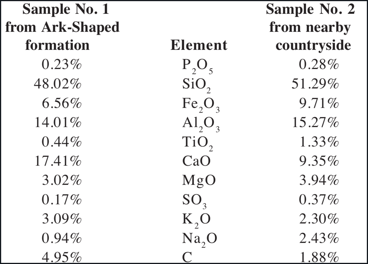
While one may regret damage done to a site of potentially great interest in the study of antiquity, this earthquake damage was not without its beneficial side-effects. In effect, it opened up a fresh section of the interior of this formation, giving Wyatt an opportunity to collect a sample of soil from that freshly exposed surface for chemical analysis. For purposes of comparison he also took a sample from the soil surface beyond the geologic flow that runs by this formation.
The analysis of these specimens was performed by Galbraith Laboratories of Knoxville, Tennessee, and their results were reported to Wyatt on October 9, 1979. While there are some differences in other elements between the two samples [25], their greatest difference lies in the amount of carbon they contained. The sample taken from the recently denuded surface of the formation revealed a carbon content of 4.95%, while the sample from the nearby countryside revealed a carbon content of only 1.88%. Thus a difference of 3% carbon is involved here, from 5% in the formation to 2% in the soil nearby. Wyatt was told by authorities in the laboratory that the amount of carbon in the former sample was consistent with that which one might find, for example, in a soil-covered peat bog. Thus while the chemical profile of this formation does not prove the presence of disintegrated wood, it does not exclude this possibility.
Stone Anchor B was also visited in 1979. Of particular interest are the shape and distribution of the crosses incised on the side of the anchor. Most obvious is the large main Byzantine cross around which all of the others are grouped. Three smaller crosses are visible in the right side, extending outwards at a 45º angle from the center of the main cross. The innermost of these three crosses is the largest and has the more formal Byzantine characteristics. To the right and above it is a smaller and more stylized cross. Above and to the right of the second cross is a third that is a little larger but also stylized.
Three smaller crosses can also be seen in the left side of the stone, extending to the left at a 45º angle from the center of the main cross. The cross that is outermost and uppermost corresponds to the cross in the same position on the right upper quadrant. The order of the two inner crosses on the left, however, has been reversed. The smaller stylized cross is now on the left while the larger cross with the more formal Byzantine characteristics is in the middle. Another formal Byzantine cross, larger than any of those above the horizontal arms, can be seen in the right lower quadrant.
The symbolism seems relatively straightforward. The large main cross around which the other seven cluster represents Noah. The next largest cross, also of the formal Byzantine type, is located in the right lower quadrant and should symbolize Noah's wife. She was next to him in importance as the mother of his sons, and she stands under his protection. Above the arms of Noah's cross, and thus emanating from him, is a row of three crosses on one side that should represent his sons. The row of three crosses on the opposite side should stand for their wives. This representation is, therefore, of eight crosses which represent the eight persons who went into the Ark, and their crosses were designed and distributed in a particular way to say something about each of them.
This scene on the side of this anchor stone can be used as evidence that the Armenian Christians of this region connected these stones, and probably the nearby formation, with Noah and his family who came through the Flood in the Ark. Iconographically, therefore, there is an early Christian tradition that can be said to have located Noah's Ark in the Tendurek Mountains and which probably rivals in age the one that has located Noah's Ark on Mt. Ararat. While too much stock should not be put in Ark traditions dating only from the Christian era, as was pointed out at the beginning of this study, this particular tradition deserves to be taken seriously, since there is suggestive archaeological evidence here to support it. Thus it appears quite probable that Armenian Christians of the first millennium A.D. noted the same features of this area that have been discussed above and also connected them with Noah's Ark.
VI. Conclusions and Prospects
The ship-shaped formation in the Tendurek Mountains was first discovered in the winter of 1959 by Capt. Ilhan Durupinar as he surveyed aerial photographs of this region. The 1960 expedition to that site confirmed the ground measurements that had been determined already from aerial photographs, but further study there was abandoned. A reevaluation of this formation was proposed in 1976 by theorizing that it may only represent the place where Noah's Ark landed, not the remains of the Ark itself. The three prominent characteristics of this formation that were emphasized in that call for its reevaluation were:
It is located in the mountains of Ararat.
It is shaped like a ship.
It is the length of the biblical Ark.
The vicinity of this formation was explored again in the summer of 1977, and an additional find was made:
Two very large pierced stones were found that strongly resemble Bronze Age stone anchors from the Mediterranean, except they are much larger.
This formation was visited again in September of 1979, and two more finds were made:
The formation has a high carbon content which is consistent with the former presence of wood there.
Iconography incised on one of the stone anchors indicates that early Armenian Christians also held a tradition that Noah's Ark landed there.
Each new discovery at this site has strengthened the case for relating it to Noah's Ark, but the question still remains as to whether there is sufficient scientific evidence with which to confirm or deny this identification with a greater degree of accuracy. Unfortunately, the prospects are not too bright for carrying out the necessary field studies. Legitimate archaeological research in eastern Turkey has been hampered by previous violations of Turkish laws. Professional archaeologists have been caught attempting to smuggle ancient artifacts out of Turkey and in publishing antiquities by individuals other than those to whom the publication rights had been given. Amateur archaeologists engaged in the search for the Ark have also violated Turkish laws on several occasions.
Thus the archaeological and political pictures in the area remain fluid at the present time and they limit the study of this site to surface exploration only. Since some positive results have already been accomplished, the value of this kind of work should not be discounted. Six lines of evidence discussed above suggest a potentially positive correlation between the Ark-shaped formation in the Tendurek Mountains of eastern Turkey and the Ark of Noah described in the Bible. Whether or not it will be possible to add any more lines of evidence to these remains uncertain in view of the current political situation in the Middle East.
FOOTNOTES
[1]1974. Noah's Ark: fact or fable? Creation Science Research Center, San Diego, California.
[2]Notably F. Navarra. 1974. Noah's Ark: I touched it, ed. D. Balsiger, trans. R. H. Utt. Logos, Plainfield, New Jersey. Also R. Noorbergen. 1974. The Ark file. Pacific Press Publishing Association, Mountain View, California.
[3](a) J. W. Montgomery. 1974. The quest for Noah's Ark. 2nd ed. Pyramid Books, New York. (b) D. Balsiger and C. E. Sellier, Jr. 1976. Sun Classic, Los Angeles, California. No personal expedition. (c) T. LaHaye and J. Morris. 1976. The Ark on Ararat. Nelson, Nashville, Tennessee.
[5]Montgomery, The quest for Noah's Ark, plates 10 and 11 between pages 192 and 193.
[6]See Navarra's book cited in note 2 above which deals with both the 1955 and 1969 expeditions. See also Cummings, Noah's Ark, pp. 271, 273.
[7]Noorbergen, The Ark file, pp. 142-144. Cf. also the references in note 9 below.
[8]The figure is that of Eryl Cummings, an inveterate Ark searcher, in 1974. The search for Noah's Ark. A Challenge to Education, II, ed. W. Lang, p. 98. Bible-Science Association, Caldwell, Idaho.
[9](a) L. R. Bailey. 1977. Wood from 'Mount Ararat': Noah's Ark? Biblical Archaeologist 40:137-142. (b) L. R. Bailey. 1978. Where is Noah's Ark? Abingdon, Nashville, Tennessee.
[17]On the cubit in antiquity, see S. H. Horn, ed. 1960. The Seventh-day Adventist Bible Dictionary, p. 237. Review and Herald Publishing Association, Washington, D.C.
[18]For a random example see the Greek ship that sank off the north coast of Cyprus in the 4th century B.C. H. W. Swiny and M. L. Katzev. 1973. The Kyrenia shipwreck: a fourth-century B.C. Greek merchant ship. In D. J. Blackman, ed. Marine Archaeology, pp. 339-359. Butterworths, London.
[21]Taken from Ibid., pp. 400-402. The line drawings represent the side view and the solid drawings represent the end view. Another solid drawing representing the top view has been added in the case of No. 1.
[24]Of the on-going use of small stone anchors, Frost notes: "Anchors in the 20 kg range, which can be handled by one man, are still used and manufactured throughout the Mediterranean.... It follows that anchors in this weight range are almost impossible to date unless they are of exceptionally distinctive shape, or happen to be inscribed, or are associated with identifiable artifacts on the seabed." Ibid., p. 405.
The certificate of analysis indicates the samples were received by the Galbraith Laboratories on October 1, 1979, and were assigned the test run numbers 1-3968 and 1-3967 respectively. The results were reported on October 9, 1979 and the report is signed by Gail R. Hutchens, executive Vice-President. Xerox copies of the originals are on file with the editor. Used by permission of Ron Wyatt.